Transcription of MileByMile
1 Road Trip GuideTennessee United states Highway #11W StateLineTennessee/Virginia State Line, at Bristol, Tennessee, This is where USRoute #11W crosses over to Virginia and terminates by merging withUS Route #11 just ahead in Bristol, Virginia. Bristol, Tennessee, a cityin Sullivan County, Tennessee, The Bristol Commercial HistoricDistrict, a historic district, listed on the National Register of HistoricPlaces is in Bristol, Tennessee, King College, EW King Library, BristolMunicipal Stadium, Holston View park , Anderson park , Rotary park ,Fairmount park and Defriece park are parks located in Bristol,Tennessee.
2 -ND11- Altitude: 1706 Hwy : WalnutHill, TNBlountville Highway, to Community of Walnut Hill, Tennessee, acommunity/CDP in Sullivan County, Tennessee, Sam's Go Kart &Game Room, Steele Creek park , Steele Creek park Lake, locatednearby, Bristol College, Altitude: 1752 : Interstate Hwy#81A Connecting Road to Interstate Highway #81, Tourism CorporationOffice lies just across Tennessee/Virginia State Line. Altitude: 1834 park Bld : BristolRgnl park Boulevard, Bristol Regional Medical Center, WellmontHolston Valley Medical Center, Sapling Grove Surgery Center,Community of Walnut Hill, Tennessee, a community (CDP) (CDP) inSullivan County, Tennessee, Altitude: 1791 : InterstateHwy #81 Intersection Interstate Highway #81, National College of Business &Technology, lies just off US #11W nearby.
3 Altitude: 1781 TN #394 :Blountville, TNJunction Tennessee Highway #394, to Community of Blountville,Tennessee, an unincorporated town in Sullivan County, Tennessee, liessouth of this juction across Interstate Highway #81. Altitude: 1644 Pike :Arcadia, TNBloomingdale Pike, to Community of Bloomingdale, Tennessee, acommunity (CDP) in Sullivan County, Tennessee, Community ofArcadia, Tennessee. Altitude: 1385 Beason Well Rd :Bloomingdale, TNNew Beason Well Road, Community of Bloomingdale, Tennessee, acommunity in Sullivan County, Tennessee, lies in the north near thestate line. Altitude: 1234 B Dennis Hwy :N John B.
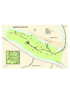
4 Dennis Highway, TN State Highway #93, Fort Patrick HenryDam, a hydroelectric dam on the South Fork Holston River justsoutheast of the city of Kingsport, Tennessee, Fort Patrick Henry Lake, warriors ' path State park , a Tennessee State park in Kingsport, SullivanCounty, Tennessee, on both the banks of South Fork Holston path Medical Center, Indian path Pavilion, located on the northside of US Route #11W in Kingsport, Tennessee. Altitude: 1240 Garden Drive :Kingsport, TNLynn Garden Drive, TN State Highway #36, Kingsport, Tennessee, acity in Sullivan and Hawkins counties in Tennessee, Holston ValleyMedical Center, Holston Valley Outpatient Center, HealthsouthRehabilitation Hospital, Putt-Putt Golf & Games, Kingsport PublicLibrary, Northeast State Community College, Kingsport Conventionand Visitors Bureau, Rascals Teen Center, Interfaith HospitalityNetwork, J Fred Johnson Stadium, J Fred Johnson park , IndianHighland park , Kingsport Parks & Recreation, Altitude.
5 1250 feetPage 1/5 PDF Document Generated on 2019-Jan-19 Copyright 2019, Mile By Mile Road Trip I-26/US Rte#23 : Eastman RecreationAreaInterchange US Route #23, Eastman Recreation Area, Bays MountainPark, Kingsport Reservoir, located south of this Intersection just offInterstate Highway #26/US Route #23. To the north lies Community ofMorrison City, Tennessee, an unincorporated community in SullivanCounty, Tennessee, close to the Tennessee/Virginia State : 1273 Inn Rd :Centennial Boat Yard ParkNetherlands Inn Road, to Centennial Boat Yard park , Riverfront park ,along Holston River in Kingsport, Tennessee.
6 Altitude: 1247 Ave : , TNHammond Avenue, Mount Carmel, Tennessee, a town located inHawkins County, Tennessee, Holston Army Ammunition Plant, anarmy ammunition plant which produces Research DepartmentExplosive and High Melting Explosive, constructed during world warII. Altitude: 1270 Street : Churc Hill,TNGoshen Valley Road, Main Street, Church Hill, Tennessee, a city inHawkins County, Tennessee, Canton Hall an Antebellum Mansion andCarter's Store, home to the first settlers west of the Appalachian, are themain landmarks here in Church Hill, Tennessee. Bays Mountain Falls,and Laurel Run Falls, are water falls located Mountain View Roadnearby.
7 Altitude: 1214 Bend Rd : StonyPoint, TNPhipps Bend Road, Community of Stony Point, Tennessee, NewProvidence Presbyterian Church, Academy, and Cemetery, a historicsite in Surgoinsville, Tennessee, built in 1785, is listed on the NationalRegister of Historic Places. Altitude: 1198 Creek Rd :Surgoinsville, TNSurgoinsville Creek Road, to Surgoinsville, Tennessee, a town inHawkins County, Tennessee, Surgoinsville 1st United Methodist,Surgoinsville Fitness Center, Altitude: 1198 Hwy : HawkinsCounty AirportRogersville Highway, to Hawkins County Airport, a public airportlocated on the south side of US Route #11W, southwest ofSurgoinsville, Tennessee.
8 Altitude: 1348 Main Street : ClinchMountainE Main Street, Cultural Art Center, Clinch Mountain, a mountain ridgein Tennessee and Virginia, Ebbing Flowing Springs Road, Ebbing andFlowing Spring, a spring located in Hawkins County, Tennessee, nearRogersville, Tennessee, is one of only two known springs of its kind, Itis a major touristic attraction in the area. Altitude: 1352 Hwy #70 : Eidson, TNTennessee Highway #70, Community of Eidson, Tennessee, anunincorporated community located on Clinch Mountain in HawkinsCounty, Tennessee, Altitude: 1309 Main Street: Rogersville,TNJunction of TN Highway #66/TN Highway 70/W Main Street Altitude:1263 Ferry Rd :Whitesburg, TNMelinda Ferry Road, TN Highway #344, to Community of Whitesburg,Tennessee, an unincorporated community in Hamblen County,Tennessee lies on TN Highway #34/US #11E.
9 Altitude: 1135 : CampgroundsAccess to, Cherokee Lake Camp Grounds, a Campgrounds Area,located just off US Route #11W on the western shore of Cherokee : 1096 Hwy #31 : Mooresburg,TNJunction Tennessee State Highway #31, Community of Mooresburg,Tennessee, located on Old Highway #11W, Old Hwy 11W does a loopon the present US #11W. Altitude: 1135 feetPage 2/5 PDF Document Generated on 2019-Jan-19 Copyright 2019, Mile By Mile Road Trip Drive : Bean Station,TNCity Drive, Bean Station, Tennessee, a city in Grainger County,Tennessee, Altitude: 1148 : US Rte #25 WJunction US Route #25W, leaves US Route #11W ending itsconcurrency and heads south across Cherokee Lake towardsMorristown, Tennessee.
10 Berrys Island Ecological Study Area, lies onthe Cherokee Lake, east off US Route #25W/TN State Highway # : 1106 : US #25E/TN #32 Junction US Route #25E/TN Highway #32, Community of Thorn Hill,Tennessee, lies along TN State Highway #131, Claiborne CountyAirport, a public airport lies northwest along Lone Mountain County park , a park located just of US #11W on the shores ofCherokee Lake. Altitude: 1096 Springs, TNCommunity of Tate Springs, Tennessee, a community located on USRoute #11W on the shores of Cherokee Lake. Altitude: 1083 Hwy #92 : Rutledge,TNTennessee Highway #92, Rutledge, Tennessee, a town in and the countyseat of Grainger County, Tennessee, Grainger County ElectionCommission, Henderson Chapel African Methodist Episcopal ZionChurch, a historic church built in 1890, is listed on the National Registerof Historic Places.