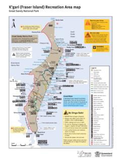
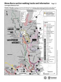
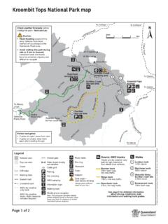
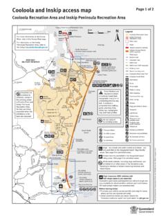
Transcription of Moreton Island National Park and Recreation Area map
1 Moreton Island National Park and Recreation Area map Scale 0 2 4 6 8km COLD. North Point Honeymoon Bay Yellow Cape Moreton Heath Patch Island oad Tailor h Po intR. Lake N14 Cape Cliff EMERGENCY. ONLY. Legend Bight or t er N Jabiru B ulw Recreation area Dog Creek Five Hills N12. Conservation park Comboyuro Point Spitfire Creek 1. N10. Settlements Bu Sand lwe Blue r . e Blu Lagoon Lagoon Private lease N8. Ro Curtin artificial reef ad No vehicle access Due to creek crossings, Honeyeater Lake Blue Lagoon 20 km/hr zone low tide access only. N6. Cravens 30 km/hr zone Creek Telegraph Cowan Cowan 2 Walking Track Special protection Caution: At times, zone and low tide 8 km N4. Beach at Cowan Cowan exposed rocks make access only closed to all through beaches impassable, traffic. Use bypass. especially after rough 4WD vehicle track Mt Tempest N2 sea conditions. Ben-Ewa Eagers Beach Walking track U-turn areas Creeks COLD One w ay One w S1. Moreton Bay Marine Park Rocks, intermittently Tangalooma The Bypass ay exposed Wrecks Middle Road Amphitheatre COLD S3.
2 Camping area Tangalooma Resort The Desert Rous Battery Camper 4WD access Tangalooma Point Walking S5 Distance markers are located Track on the ocean beach at 2 km Ranger station intervals north (N followed by an even number) and south (S and Toilets Moreton Bay Marine Park km an odd number) of Middle Road. S7. Portable toilet waste In an emergency dial 000 or if no disposal mobile reception try 112. If White Rock calling from ocean beach, advise Showers (cold). Shark Spit S9. operator of your closest distance marker. (Marker positioning not Walking track to scale). Lookout S11. Bins State of Queensland. Queensland Parks and Wildlife Service. MA396 October 2018. Caution: The beach between Rous Battery Kooringal and Tangalooma is not always trafficable. Debris and Information shifting sand may make the beach Big S13. impassable even at low tide. Vehicle ferry Sandhills Wreck Beach safety zones provide S15 Lighthouse added safety for pedestrians. Little Special protection zone and no high All vehicles must not exceed Sandhills tide vehicle access at Mirapool.
3 Vehicles Ambulance 30 km/hr at all times in front of must not exceed 30 km/hr below half Emergency Services and between: S17 tide. No vehicle access at high tide. helipad Ben-Ewa and The Wrecks Toulkerrie Mirapool Lagoon Water campgrounds, and (treat before use). Barge landing areas at: - Reeders Point S19 Spearfishing - The Wrecks prohibited - Bulwer (20 km/hr). Don't drive N2. Kooringal 3 Short Point near shorebirds S7 Distance markers Beaches are closed to vehicles in front of: Cowan Cowan settlement Campbell Point Note: Four marine National park (green) zones for Moreton Tangalooma Resort Day's Gutter Reeders Point Bay Marine Park overlap beaches on Moreton Island . All forms of collecting including fishing are prohibited. For more details visit For a more detailed map of the roads, walking tracks and highlights to see, visit Page 1 of 2. Locality map and inset maps 1, 2 and 3. Legend Recreation area Camping area Water 1 No vehicle access 2 20 km/hr zome Low tide Special protection access only zone and low tide access only Comboyuro Point camping area 4WD vehicle track Locality map Cowan Cowa n By Walking track Coral Sea Cowan Cowan Toilets Showers (cold).
4 R th St State of Queensland. Queensland Parks and Wildlife Service. MA396 October 2018. Refreshments 20L drums pas Moreton Island o only Restaurant Wadsw 3. s Thoma To Toulkerrie and To To s General store Pamph ocean beach Ca airstrip Blue Lagoon lett hu St mb Jessie Tailor Bight Accommodation aS. St North Point St t Brisbane en Bins eslie Ta dg St lma Portable toilet Bulwer Mi n am L. Kooringal waste disposal The Str Bulwer al Esp Petrol (20L drums only). Willi Moreton Wrecks Bak eerin g St Amphitheatre and s g ypas Koorin Kak Telephone St oog un S Gold Coast er B. t Wreck Bulw t Djaloon S Airstrip Queensland Emergency Deeman St Services helipad Scale Scale Scale Scale 0 200 400m 0 200 400m 0 200 400m 0 20 40km Water New South Wales (treat before use). Page 2 of 2.