Transcription of Naranja Community Urban Center (NCUC) District
1 Article XXXIII(J), chapter 33, Code of miami - dade county , Florida Naranja Community Urban Center (NCUC) District The Naranja Community Urban Center District was adopted into the zoning code in 2004 by Ordinance 04-217. This District was subsequently amended in 2005, 2006, 2007, and 2015 by ordinances 05-145, 06-11, 07-96, and 15-65. This document is formatted for clarity in text and graphics. For the official adopted article, refer to the Code of miami - dade county published by the Municipal Code Corp., available online at Sec. Purpose, intent and applicabil-ity. 1. The Comprehensive Development Master Plan (CDMP) contains directives to promote Urban centers in places where mass transit, road-ways, and highways are highly accessible.
2 The CDMP provides for three types of Urban cen-ters: Community (CUC), metropolitan (MUC) and regional (RUC). CUCs are a mechanism by which those CDMP directives can be ad-dressed, because CUCs are compact, mixed-use, and pedestrian-friendly areas. In the Na-ranja CUC area these CDMP directives are in-tended to be achieved by the following means: A. allocating development intensities within the Naranja CUC according to proximity to mass transit, and by creating Core, Center and Edge sub-districts to allocate the vari-ous development intensities within the CUC; and B. by organizing an interconnected network of tree-lined streets and sidewalks to im-prove pedestrian access to transit, jobs, and shopping; and C.
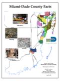
3 By providing for open space with specific square, green and/or plaza locations, and by shaping the way buildings front onto open space and streets. 2. The regulations contained in this chapter and chapter 18-A, Code of miami - dade county , Florida, shall apply to this article, except as otherwise added to or modified herein. 3. The Illustrative Plan (Figure 1), shall be used to assist in interpreting this article. Where there is conflict between the Illustrative Plan and the text of this article, the text shall govern. 4. The boundaries shown in Figure 1 shall consti-tute the Naranja CUC Boundary Plan and are generally described as follows.
4 From the northwest corner of the intersection of SW 137 Avenue and SW 272 Street, north along the west side of SW 137 Avenue to the south side of SW 256 Street, then west along the south side of SW 256 Street, then west along the south side of SW 256 Street to the Urban De-velopment Boundary (UDB) line, as of January 1, 2015, then south and west along the UDB to the centerline of SW 149 Avenue, then south along the centerline of SW 149 to the C-103N canal, then southeast along the canal to the north side of SW 272 Street to the west side of SW 142 Avenue to the south side of SW 270 Street, then east along the north side of SW 270 Street to the east side of the Naranja Ca-nal easement, then southeast and south along the east side of the Naranja Canal easement to the north side of SW 272 Street.
5 Then east along the north side of SW 272 Street to the west side of SW 137 Avenue. The exact loca-tion of the UDB line is on file with the Depart-ment of Regulatory and Economic Resources or its successor department. An approximate delineation of the UDB line is depicted in the Regulating Plans. Any amendment to the CDMP resulting in a movement of the UDB line following the effective date of this ordinance shall be followed by an amendment to this section of the code to reflect the new UDB line or the westernmost boundaries of the NCUC in 2 District Regulations compliance with the half-a-mile radius CDMP requirement for Community Urban Centers.
6 A more detailed legal description of the boundaries follows: Begin at the NE corner of the SE of Section 27-56-39. Thence W. along the centerline of SW 256 St. for a distance of 1877 + to the centerline of State Hwy. #5 for 285 +/- to a point. Thence N47-04 -12 W for 300 +/- to the centerline of SW 256 St. Thence W. along SW 256 St. centerline for 1600 +/- to a point. Thence S. along the theoretical W/ly R/wy of SW 147 Avenue for 850 +/- to the N/ly R/wy of SW 264 St. Thence W. along the N/ly line of SW 264 St. for 1287 +/- to theoretical Center -line of SW 149 Ave.
7 Thence S. along SW 149 Ave. for 1030 +/- to the N/ly R/wy of Canal C-103 N. Thence SE/ly along the N. line of canal for 2450 +/- to the centerline of SW 272 St. Thence E. along SW 272 St. centerline for 2340 +/- to the centerline of SW 142 Ave. Thence N. along SW 142 Ave. for 682 +/- to the centerline of SW 270 St. Thence E. for 1050 +/- to the W. line of FEC EASEMENT. Thence SE/ly along the W. line of FEC EASE-MENT 464 +/- to the W. line of the SW 1/4 of the SE 1/4 of the NE 1/4 of Section 34-56-39 thence south 410 +/- to the centerline of SW 272 St.
8 Thence E. 1350 +/- along the Center -line of SW 272nd St. to SW 137 Ave. Thence N. along SW 137 Ave. for a distance of 5280 +/- to the point of beginning. Full scale maps of the Illustrative Plan pre-sented in Figure 1, as well as the Regulating Plans and Street Development Parameters fig-ures in this article, are on file with the miami - dade county Department of Regulatory and Economic Resources or its successor depart-ment. 5. No provision in this article shall be applicable to any property except lands lying within the boundaries of the Naranja Community Urban Center District as described herein.
9 No prop-erty lying within the boundaries of the Naranja Community Urban Center shall be entitled to the uses or subject to the regulations provided in this article until an application for a District boundary change to the Naranja Community Urban Center District has been heard and ap-proved in accordance with the provisions of this chapter . Naranja Community Urban Center 3 Figure 1: Illustrative Master Plan 4 District Regulations Sec. Naranja Community Urban Center District (NCUC) Requirements. Except as provided herein, all developments within the NCUC shall comply with the requirements pro-vided in Article XXXIII(K), Standard Urban Center District Regulations, of this code.
10 Sec. Uses Except as provided herein, all permitted, condi-tionally permitted, and temporary uses within the NCUC shall comply with Section of this code, A. Permitted Uses. In addition to the uses pro-vided in Section , the following shall be permitted: 1. In the Industrial District (ID) area, all uses permitted in the IU-2 zoning District if ap-proved after public hearing pursuant to Section 33-311(A)(3) of this code. 2. In the Mixed-Use Optional (MO) area: Live-work units. 3. In the Market District (MD) area: a. outdoor produce markets as a perma-nent use and not subject to restrictions on temporary uses set forth in Section (A)(5), and b.