Example: bankruptcy

Noosa National Park walking tracks map Headland Section

Enterprise StHastings StNoosa DrViewland DrBeach RdDavid Low WayBen Lexcen DrSolway DrCooyar StNoosa PdeMcAnally DrLaguna BayTea TreeBayWinchCovePicnicCoveGranite Bay Alexandria BayLionRockNoosa Heads SurfLife Saving ClubSunshine BeachSurf Life Saving ClubBoilingPotDay-use areaDolphinPointHell sGatesLaguna LookoutSunshine BeachDukeSunshineDavid Low WaySurf StEmergencyradioSunshineBeachParkedge RdMorwongDriveBicentennial Dr31244542 park RdStSeaview TceNoosa Hill(limited views) State of Queensland. Queensland Parks and Wildlife Service. MA269 February 2021 LegendNational parkWaterSealed roadCouncil walking pathwayManagement access onlyVisitor information centreNoosa Headland Section walking track mapNoosa National Grove walk returnTanglewood walk 8km returnNoosa Hill walk returnCoastal walk returnBarrier free path from the day-use area to Dolphin Point.

Visitor information centre Noosa Headland section walking track map Noosa National Park 0.5 1km Scale 0 Palm Grove walk 1.1km return Tanglewood walk 8km return Noosa Hill walk 2.8km return Coastal walk 10.8km return Barrier free path from the day-use area to Dolphin Point. Beyond Boiling Pot gradients exceed 1:10 (5.7 degrees) for short sections.

Tags:

  Information, Park, National, National park

Information

Domain:

Source:

Link to this page:

Please notify us if you found a problem with this document:

Other abuse

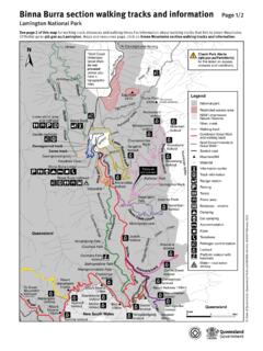
Transcription of Noosa National Park walking tracks map Headland Section

1 Enterprise StHastings StNoosa DrViewland DrBeach RdDavid Low WayBen Lexcen DrSolway DrCooyar StNoosa PdeMcAnally DrLaguna BayTea TreeBayWinchCovePicnicCoveGranite Bay Alexandria BayLionRockNoosa Heads SurfLife Saving ClubSunshine BeachSurf Life Saving ClubBoilingPotDay-use areaDolphinPointHell sGatesLaguna LookoutSunshine BeachDukeSunshineDavid Low WaySurf StEmergencyradioSunshineBeachParkedge RdMorwongDriveBicentennial Dr31244542 park RdStSeaview TceNoosa Hill(limited views) State of Queensland. Queensland Parks and Wildlife Service. MA269 February 2021 LegendNational parkWaterSealed roadCouncil walking pathwayManagement access onlyVisitor information centreNoosa Headland Section walking track mapNoosa National Grove walk returnTanglewood walk 8km returnNoosa Hill walk returnCoastal walk returnBarrier free path from the day-use area to Dolphin Point.

2 Beyond Boiling Pot gradients exceed 1:10 ( degrees) for short access subject to storm surges and tidal influencesAlexandria Bay walk returnWalking track linkParkingBus stopInformation centreToiletsWheelchair accessWi-fiViewpointPicnic tableBarbecue electricDrinking waterShowerPatrolled swimmingBeware swimming not advisedHigh surf12345 walking track legendFor bus information call 13 12 30, visit or download the MyTransLink animals and bike riding prohibited in the National park .


Related search queries