Overground Network map-May 2016(e)
Title: Overground Network map-May 2016(e) Author: Transport for London Subject: Overground Network map-May 2016\(e\) Created Date: 5/13/2016 1:37:29 PM
Tags:
Information
Domain:
Source:
Link to this page:
Documents from same domain
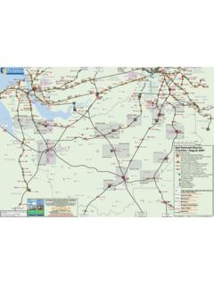
RAIL MAP 1 Cheshire County Rail Network Map
www.projectmapping.co.ukM M M M M M M M M M M M M M M Queensferry Mold Northop Ewloe Broughton Kinnerton Connah’s Quay Manchester International Airport M Chester City Rail Link Free Bus Link betweek Chester

First Great Western Network Map - …
www.projectmapping.co.ukSouthampton Airport GATWICK AIRPORT Heathrow Airport READING Exeter Airport Cardiff International Airport St Erth Malvern Link Great Malvern Colwall Ledbury

10026-SE Network Route Map Update - …
www.projectmapping.co.uk1 2 3 4 5 6 2 1 3 4 5 6 Westenhanger Sandwich e s k te a Sea r ne m m le e y y Deal Walmer Martin Mill Chartham Chilham Aylesham …
Ebbw Vale Abertillery Merthyr Tyd˜l Parkway …
www.projectmapping.co.ukHirwaun Abertillery Map of potential Metro network Abergavenny Celtic Manor Chepstow Severn Tunnel Junction Cwmbran Pontypool & New Inn BRIDGEND Swansea &
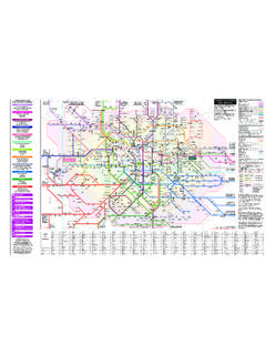
London Connections National Rail Train Operating …
www.projectmapping.co.ukAbbey Wood.....S4 Acton Central.....M3 Acton Main Line .....L3 Acton Town.....L3
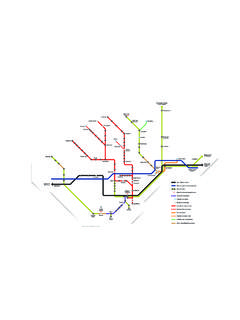
Eurostar connections - projectmapping.co.uk
www.projectmapping.co.ukAvignon Valence Lyon Marseille Montpellier PARIS Bordeaux Nantes Rennes Le Mans Dijon Lille BRUSSELS AMSTERDAM Rotterdam Strasbourg Antwerp Annecy …

STAFFORD SHREWSBURY RUGELEY TRENT VALLEY …
www.projectmapping.co.ukFarringdon City Thameslink Blackfriars Broadstairs Dumpton Park Bromley South Dartford East Croydon Clapham Junction Surbiton Coulsdon South Leatherhead Upper

RAIL 2018 - projectmapping.co.uk
www.projectmapping.co.ukFirst Capital Connect Southern Southeastern c2c First Capital Connect Victoria Croydon Tramlink DLR Victoria Hammersmith & City Kenley Chingford Harold Wood Brentwood

Spoorkaart van Nederland - projectmapping.co.uk
www.projectmapping.co.ukA B C D E F A B C D E F 7 2 3 1 4 5 6 7 2 3 1 4 5 6 Mönchengladbach Hbf Hamm (Westf) Frankfurt Flughafen Fernbahnhof Frankfurt (M) Hbf Düsseldorf Hbf Duisburg Hbf
Travelcard Zones Map Mar 08 - projectmapping.co.uk
www.projectmapping.co.uk8 78 9 River Thames River Thames Station outside the zones Station in Zone 5 Station in Zone 4 Station in Zone 3 Station in Zone 2 Station in both zones
Related documents

Welcome to London - Visitor guide
vlstatic.comWELCOME TO LONDON SUMMER 2012/13 INFORMATION TO START YOUR VISIT Includes Tube + Bus maps TR127708_TfL_Welcome_To_London_CR4_Layout 1 14/06/2012 12:25 Page 1

Your guide to accessibility - vlstatic.com
vlstatic.com2 Safety and Security As passenger numbers on the Capital’s public transport network are increasing and the rate of crime on the network continues to fall, TfL is …

Network Railcard Area
www.railcard.co.ukBroadstairs Dumpton Park Bromley South London Bridge Cannon Street Dartford Victoria Otford Sevenoaks East Croydon Waterloo Charing Cross Clapham Junction Wimbledon
LONDON TERMINAL STATIONS - National Rail …
www.nationalrail.co.ukThrough services to Paris and Brussels St. Albans Aylesbury Luton Airport Aylesbury Vale Parkway Lichfield Alfreton Rugeley GRIMSBY New Holland Keighley

AS6939 Contact us today at: 1 510-580-4190 or …
he.netAS6939 Contact us today at: +1 510-580-4190 or sales@he.net Nairobi < To Paris, Djibouti & Dubai Bogota Nw York Boston Philadelphia Charlotte Atlanta Miami Dallas Chicago Houston Saint Louis Columbus Toronto Montreal
1 page document - water footprint
waterfootprint.orgThe WaTer FooTprinT assessmenT manual Hardback PPC: Live area – 159 x 240mm – Trim size – 156 x 234mm – Bleed – 18mm – Spine – 24.2mm