Transcription of Overview of Coordinate Reference Systems (CRS) in R
1 Overview of Coordinate Reference Systems (CRS) in R Coordinate Reference Systems CRS provide a standardized way of describing locations. Many different CRS are used to describe geographic data. The CRS that is chosen depends on when the data was collected, the geographic extent of the data, the purpose of the data, etc. In R, when data with different CRS are combined it is important to transform them to a common CRS so they align with one another. This is similar to making sure that units are the same when measuring volume or distances. Package sp and rgdal is used to assign and transform CRS in R: library(rgdal) library(sp) In R, the notation used to describe the CRS is proj4string from the library.
2 It looks like this: +init=epsg:4121 +proj=longlat +ellps=GRS80 +datum=GGRS87 +no_defs +towgs84= , , There are various attributes of the CRS, such as the projection, datum, and ellipsoid. Some of the options for each variable can be obtained in R with projInfo: : projInfo(type = "proj") : projInfo(type = "datum") : projInfo(type = "ellps") EPSG codes A particular CRS can be referenced by its EPSG code ( , epsg:4121). The EPSG is a structured dataset of CRS and Coordinate Transformations. It was originally compiled by the, now defunct, European Petroleum Survey Group. Here are some websites: (although I find these kind of confusing).
3 In R, the details of a particular EPSG code can be obtained: CRS("+init=epsg:4326") Which returns: +init=epsg:4326 +proj=longlat +ellps=WGS84 +datum=WGS84 +no_defs +towgs84=0,0,0 A data frame of all the CRSs can be created: EPSG <- make_EPSG() which returns a data frame with columns: code: EPSG code note: notes as included in the file prj4character: attributes for the projection The EPSG dataframe can be searched: EPSG[grep("4269", EPSG$code),] EPSG[grep("HARN", EPSG$note),] tmp <- EPSG[(grep("longlat", EPSG$prj4)), ] EPSG codes for commonly used CRS (in the ) Latitude/Longitude WGS84 (EPSG: 4326) ## Commonly used by organizations that provide GIS data for the entire globe or many countries.
4 CRS used by Google Earth NAD83 (EPSG:4269) ##Most commonly used by federal agencies. NAD27 (EPSG: 4267) ##Old version of NAD83 Projected (Easting/Northing) UTM, Zone 10 (EPSG: 32610) ## Zone 10 is used in the Pacific Northwest mercator (EPSG: 3857) ## Tiles from Google Maps, Open Street Maps, Stamen Maps CRS in R for sp classes: Some spatial data files have associated projection data, such as ESRI shapefiles. When readOGR is used to import these data this information is automatically linked to the R spatial object. To retrieve the CRS for a spatial object: proj4string(x) To assign a known CRS to spatial data: proj4string(x) <- CRS("+init=epsg:28992") or, type in the attributes: proj4string(x) <-CRS("+proj=utm +zone=10 +datum=WGS84") To transform from one CRS to another: newData <- spTransform(x, CRS("+init=epsg:4238")) or, Reference the CRS of another spatial object: newData <- spTransform(x, proj4string(OtherData)) for rasters: To retrieve or describe the CRS: projection(x) projection(x) <- CRS( +init=epsg:28992 ) To transform from one CRS to another.
5 NewData <- projectRaster(x, proj4string(OtherData)) Finding CRS data for your data - metadata - the .prj file of shape files (automatically detected by R when data is loaded with readOGR) - data source (Google Earth = WGS84long/lat) - can be challenging! Page 1, Melanie Frazier ellipses and datums Datums Provides the information needed to anchor the abstract coordinates to the Earth. The datum defines an origin point of the Coordinate axes and defines the direction of the axes. I think of this as the base information needed to draw the imaginary Coordinate lines on a globe or map. The datum always specifies the ellipsoid that is used, but the ellipsoid does not specify the datum!
6 Datums are based on specific ellipsoids and sometimes have the same name as the ellipsoid. Available options in R projInfo(type = "datum"): name ellipse definition WGS84 WGS84 towgs84=0,0,0 GGRS87 GRS80 towgs84= , , NAD83 GRS80 towgs84=0,0,0 NAD27 clrk66 nadgrids=@conus, @alaska, potsdam bessel towgs84= , , carthage clark80 towgs84= , , hermannskogel bessel towgs84= , , ire65 mod_airy towgs84= , , , , , , nzgd49 intl towgs84= , , , , , , OSGB36 airy towgs84= , , , , , , Ellipses Determining the shape of the earth is the first step in developing a CRS.
7 An ellipse is a simple model describing the basic shape of the Earth. All mapping and Coordinate Systems are based on this shape. The Earth is almost spherical, however there is a tiny bulge at the equator that makes it ~ larger than at the poles. The ellipsoid is an approximation and does not fit the Earth perfectly. There are different ellipsoids in use, some are designed to fit the whole Earth (WGS84, GRS80) and some are designed to fit a local region (NAD27). Local ellipses can be more accurate for the area they were designed for, but are not useful in other parts of the world. The modern trend is to use a global ellipsoid for compatibility, such as WGS84.
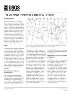
8 The local-best fitting ellipsoid is now considered an old-fashioned concept, but many maps are based on these ellipsoids. The Ellipse: Describes the generalized shape of the Earth. All mapping and Coordinate Systems begin with this description. A Globe A 3D ellipse with Lat/Long coordinates The Datum: Defines origin and orientation of the Coordinate axes (as well the size/shape of Earth) A Map A 2D representation of the 3D Earth with Easting/Northing coordinates An Overview of ellipses, datums, and projections The Projection: Project the globe onto a 2D surface There are lots of ways to do each step, resulting in lots of Coordinate Reference Systems .
9 Some common ellipsoid models: Page 2, Melanie Frazier Unprojected/Geographic: Lat/Long Locations on Earth s three-dimensional spherical surface are referenced using Latitude and Longitude. The Latitude and Longitude coordinates for a particular location will differ depending on the CRS and when the measurement was taken. Projected vs. Unprojected The 3 most common in : WGS84 (EPSG: 4326) +init=epsg:4326 +proj=longlat +ellps=WGS84 +datum=WGS84 +no_defs +towgs84=0,0,0 ## CRS used by Google Earth and the Department of Defense for all their mapping. Tends to be used for global Reference Systems . GPS satellites broadcast the predicted WGS84 orbits.
10 NAD83 (EPSG:4269) +init=epsg:4269 +proj=longlat +ellps=GRS80 +datum=NAD83 +no_defs +towgs84=0,0,0 ##Most commonly used by federal agencies. Aligned with WGS84 at creation, but has since drifted. Although WGS84 and NAD83 are not equivalent, for most applications they are considered equivalent. NAD27 (EPSG: 4267) +init=epsg:4267 +proj=longlat +ellps=clrk66 +datum=NAD27 +no_defs +nadgrids=@conus,@ ##Has been replaced by NAD83, but is still encountered! Datum shift between NAD27 and NAD83 NAD83 vs. WGS84 The initial definition of NAD83(1986) was equivalent to WGS84. Over time, the two Systems have diverged, primarily due to refinements ( realizations) made to both Systems .