Example: bankruptcy

Pachaug State Forest - Connecticut

Pachaug State ForestPachaug Enduro Map Date - February 19, 2008 ExplanationBlueWhiteYellowNo BlazeTrails/Roads Located By GPS MethodsPachaug Enduro RouteNotes:Enduro route interpreted to follow GPS trail whentrail color overlays enduro route route interpreted to follow existing highwaywhen black line overlays enduro symbol. Enduro route digitized from 1:24,000 scale topograhpicmapping when enduro symbol is solid boundaries of State -owned property asshown on this map are RouteMap Date - February 22, 2008 GPS locations obtained using Trimble Pro XR receiver(2-8 meter accuracy w/PDOP=10, SNR= , Post processed) Pachaug State ForestQuinebaug Fish HatcheryBlue YellowPachaug Forest RoadsBlue/OrangeBlue/R

Pachaug State Forest Pachaug Enduro Route 0 0.25 0.5 1 1.5 2 µ Miles Map Date - February 19, 2008 Explanation Blue White Yellow …

Tags:

  States, Forest, Connecticut, Enduros, Pachaug state forest, Pachaug

Information

Domain:

Source:

Link to this page:

Please notify us if you found a problem with this document:

Other abuse

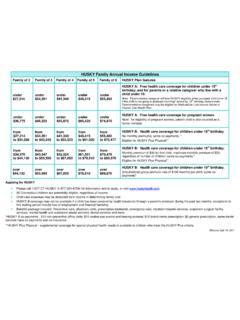
Transcription of Pachaug State Forest - Connecticut

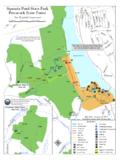
1 Pachaug State ForestPachaug Enduro Map Date - February 19, 2008 ExplanationBlueWhiteYellowNo BlazeTrails/Roads Located By GPS MethodsPachaug Enduro RouteNotes:Enduro route interpreted to follow GPS trail whentrail color overlays enduro route route interpreted to follow existing highwaywhen black line overlays enduro symbol. Enduro route digitized from 1:24,000 scale topograhpicmapping when enduro symbol is solid boundaries of State -owned property asshown on this map are RouteMap Date - February 22, 2008 GPS locations obtained using Trimble Pro XR receiver(2-8 meter accuracy w/PDOP=10, SNR= , Post processed) Pachaug State ForestQuinebaug Fish HatcheryBlue YellowPachaug Forest RoadsBlue/OrangeBlue/R


Related search queries