Transcription of Plate Boundaries N T P. IRIS Animations
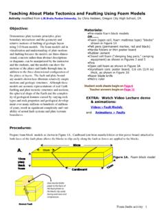
1 Plate Boundaries LINK TO P. 4. Background to accompany the Animations & videos on: IRIS Animations Vocabular y Plate Tectonics Boundaries where plates are moving toward each other, and Plate tectonics theory describes how the lithosphere of the sometimes one Plate sinks (is subducted) beneath another. The Earth is broken into various plates. These plates drift on the location where the sinking of a Plate occurs is called a subduction asthenosphere at very slow rates. As plates move away from zone. A transform boundary is where plates slide past each other each other the lithosphere thins and tears. At these divergent with no creation or destruction of lithosphere. Plate Boundaries new oceanic lithosphere is created in the gaps from upwelling magma from the mantle.
2 This upwelling Plate Margin Examples magma forms mid-ocean ridges, long mountain chains that There are three general types of Plate Boundaries : divergent, mark the Boundaries between diverging plates. convergent, and transform. Each general type has multiple The static size of the Earth implies that crust must be species': divergent Boundaries can be spreading ocean ridges or destroyed at about the same rate it is being created. Plate continental rift zones; convergent Boundaries can occur between tectonics provides the mechanism to recycle the Earth's crust. two oceanic plates, an oceanic and continental Plate , or between Destruction (recycling) of crust takes place along convergent two continental plates. TOUCH HERE. to link to video lecture on Plate tectonics Divergent Margins Divergent Boundaries occur where plates are moving apart.
3 Hot mantle O ceanic crust rock rises and Crust L ithosphere M antle partial melting Lithosphere occurs. New crust Mantle is created by the Asthenosphere magma pushing up from the Asthenosphere Partial melt mantle. Partial melt Fast-spreading ridges Mountain chain forms CLICK HERE Slow-spreading ridges form valleys on the ridge along the crest of the ridge. High heat and magma to watch crests. Lower heat input (Ex. Mid-Atlantic Ridge). input making the ridge bouyant. New crust is animation of The early onset of extension forms a basin-and- added both as dikes and as erupted lava (Ex. East processes. range province of parallel mountains and valleys Pacific Rise). dispersed across a broad uplifted area. Most of the information in this Background document is modified from 1.
4 *NOTE: on these drawings, the crust appears separate from the lithosphere. The crust is part of the lithosphereic Plate . Transform Margins Spreading Tra n s fo r m f a u l t ridge Two plates slide against each other. Spreading Left: Offset seen on the ridge road and stream crossing the fault (Example: San Lithosphere Crust Andreas Fault, California). Right: Transform faults also Asthenosphere form the margin between Partial melt offset spreading ridges. Convergent Margins Crust is destroyed as two plates move towards each other. The heavier Plate dives (subducts) beneath the more-bouyant Plate . Is la n d arc ch Oceanic-oceanic convergence When two oceanic plates en converge, one subducts beneath the other, and in the process Tr Continental Lithosphere Oceanic crust crust a trench is formed.
5 (Example: The Marianas Trench, the Lithosphere Challenger Deep, at the southern end of the Marianas Trench, plunges deeper into the Earth's interior (nearly 11,000 m) than Asthenosphere O. Mount Everest, the world's tallest mountain, rises above sea Asthenosphere ce an ic level (about 8,854 m).) Inboard of the overlying Plate a volcanic cr us arc forms. This is because water being released from the t subducting slab facilitates melting of the overlying mantle. The melt rises to form volcanoes. (Ex. the Aleutian Islands.). Oceanic-Continental convergence An oceanic Plate converges on a continental Plate and the denser crust of the c Vo l c a n i arc oceanic Plate sinks beneath the more-bouyant continental ch Plate . In this type of convergence, trenches, strong, destructive en earthquakes and the rapid uplift of mountain ranges are Tr Continental.
6 Common. Water released from subducting slab facilitates O ce a n i c c r u s t ..crust melting. Rising melt builds volcanic arc. (Examples: Juan de Lithosphere Fuca Plate subducting beneath the North American Plate off Lithosphere shore in the Pacific the coast of South America .. along the Peru-Chile trench, the oceanic Nazca Plate is being .. Asthenosphere .. subducted beneath the South American Plate . In turn, the overriding South American Plate is being lifted up, creating the towering Andes mountains.). CLICK HERE to watch animation of oceanic-continental subduction. High R an t a i n e Pl atea u ng Continental-continental convergence When two continents u Mo meet head-on, neither is subducted because the continental Co nti n enta l cru s t rocks are relatively light and, resist downward motion.
7 Instead, Conti ne nt al c rust the crust tends to buckle and be pushed upward or sideways. Litho sphe re L i th o s p h ere (Example: The Himalayan mountain range dramatically demonstrates one of the most visible and spectacular Asthe nosphe re O. ld consequences of Plate tectonics. The Himalayas, towering as o ce high as 8,854 m above sea level, form the highest continental an mountains in the world.). ic cr u st 2. The Earth's Layers The Earth is a layered planet consisting of crust, mantle, and an inner and outer core. Approximately 100 km of the outermost part is a rigid layer called the lithosphere, which includes the crust and uppermost mantle. This lithosphere is broken into a number of large and small plates (slabs) that move over a plastic' (more accurately called viscoelastic) layer in the upper mantle called the asthenosphere.
8 Note the relative thicknesses of this The movement of these plates is diagram are greatly exaggerated to show called Plate tectonics. the crust. USGS Graphic. Earth's Magnetic Field A B. Most of the Earth's magnetic field is caused by motions of liquid metal in the outer core as the planet rotates. The Earth's magnetic field is similar to that generated by a simple bar magnet (Fig. A). The field behaves as if the magnet were located through the axis of the Earth's rotation. Currently, it is inclined about 11 degrees from the geographic axis of rotation. However, magnetic north is not fixed, and the location drifts at rates up to degrees per year. At present, the lines of force of the Earth's magnetic field are normal polarity C. (Fig. B). The negative magnetic pole is in the Northern Hemisphere and the positive magnetic pole is in the Southern Hemisphere.
9 However, the Earth's magnetic field periodically reverses; the north magnetic pole becomes the south pole and vice versa. L I N K to The Earth has experienced periods of this annimation reversed polarity alternating with times of of sea-floor normal polarity. spreading model These magnetic fields are recorded on by Tanya the ocean floor (Fig. C). Magmas contain Atwater, iron-bearing minerals such as magnetite UCSB. which acts like a compass. As these iron-rich magmas cool, they become magnetized in the direction of the surrounding magnetic field. As magma rises to form new ocean floor at a mid-ocean spreading center, it records the polarity of the magnetic field existing at the time magma crystallized. As spreading pulls What drives the plates?
10 The new oceanic lithosphere apart, stripes The jury is still out on exactly how plates are propelled by mantle of approximately the same size are carried convection. What is known is that the upwards motion of hot mantle below away from the ridge on each side. Seafloor spreading ridge in concert with slab pull (subduction) at the margin of maps of magnetic anomalies can be used the plates are important factors. For a discussion on this, go to USGS's to compare and establish mid-ocean ridge Unanswered Questions' about convection and Plate tectonics. spreading rates. 3. Vocabulary (from USGS Visual Glossary and Photo Glossary of Volcanic words). Accretionary wedge Sediments, the top layer of material on a tectonic Plate , that accumulate and deform where oceanic and continental plates collide.