Transcription of RECORDS OF SURVEY AND CORNER RECORDS - San Diego …
1 MANUAL OF INSTRUCTION FOR FILING RECORDS OF SURVEY , CORNER RECORDS , AND CERTIFICATES OF CORRECTION REVISED JUNE 10, 2010 San Diego County Surveyor CHAPTER 3 RECORDS OF SURVEY AND CORNER RECORDS Section Page Purpose of a Record of SURVEY ..2 When a Record of SURVEY is When a Record of SURVEY is Not Required ..5 Responsibilities of the Private Surveyor or Processing Record of SURVEY Check General Map Data.
2 10 Miscellaneous Mapping Sample Recorded RECORDS of CORNER Sample Filed CORNER Certificates of 2 GUIDELINE. It is the purpose of this manual to follow the procedure for filing RECORDS of SURVEY and CORNER RECORDS as established by the County Engineer s Association of California on March 10, 1989 and revised March 27, 2009. The recommended guidelines for RECORDS of SURVEY are not to be construed as representing the only method or as an interpretation of the Professional Land Surveyor's Act.
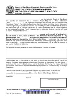
3 PURPOSE OF A RECORD OF SURVEY . The record of SURVEY is the means by which field surveys relating to property lines, land boundaries or other subjects are brought to public s attention. The Professional Land Surveyor's Act (Business and Professions Code, Chapter 15, Division 3, Section 8700 et seq.) provides two circumstances for filing a record of SURVEY with the County Surveyor. 1) A surveyor may file any field surveys made in conformance with the practice of land surveying as defined therein. 2) A surveyor shall file all field surveys relating to land boundaries or property surveys which disclose those specific criteria defined in Section 8762(b) ( material evidence, physical change, material discrepancies, alternate positioning, and/or establishment of points, lines or boundaries, etc.
4 See Section The thrust of the law is clear that all surveys relating to property be recorded, that i) all monuments set to denote property corners, ii) boundary lines between parcel ownership, iii) in certain circumstances, the monumentation of any easements or auxiliary lines be made a public record, and iv) to clarify any discrepancies found in subdivision maps, official maps, or RECORDS of SURVEY . WHEN A RECORD OF SURVEY IS REQUIRED. A licensed land surveyor or registered engineer establishes, and is subject to the record of SURVEY filing requirements, when he or she represents beyond a reasonable doubt or dispute the location, relocation, establishment, reestablishment or retracement of a boundary or property line to another party pursuant to the provisions of Section 8762 of the California Professional Land Surveyor s Act.
5 This representation includes the act of causing a boundary or property line to be accepted or recognized, to prove or demonstrate the location of the boundary or property line, the setting, resetting, or replacement of a CORNER , references or witness monuments or the reference of a boundary or property line by showing dimensional ties to the line in relation to physical features or monuments located on the ground. California Board of Registration for Professional Engineers and Land Surveyors. January 3, 2007 3 A record of SURVEY is required of a field SURVEY whenever any of the following conditions exist: A.
6 THE SURVEY DISCLOSES ANY OF THE FOLLOWING: Material evidence or physical change, which in whole or in part does not appear on any subdivision map, official map, or record of SURVEY previously recorded or filed in the office of the County Recorder or County Surveyor, or map or SURVEY record maintained by the Bureau of Land Management of the United States. "Material evidence" has been defined as evidence of sufficient importance as to affect the outcome of a court case, and includes, but is not limited to, the particular items mentioned in Section 8764 of the Professional Land Surveyor s Act.
7 "Physical change" would apply to topographic or landmark features of importance to the SURVEY ( thread of the stream, mean high water, etc), which, if not noted, may adversely affect the interpretation of the SURVEY . As regards monuments, physical change would include the discovery of any evidence pertinent to a monument (except as discussed above) which differs from the previous existing record of said monument. B. THE SURVEY FINDS ANY OF THE FOLLOWING: Material discrepancy with the information contained in any subdivision map, official map, or record of SURVEY previously recorded or filed in the office of the county recorder or the county surveying department, or any map or SURVEY record maintained by the Bureau of Land Management of the United States.
8 Section 8762(b) of the Professional Land Surveyor's Act limits material discrepancy to the position of lines or points, or to dimensions. Factors such as the date(s) of the SURVEY (s), the SURVEY methods and equipment contemporaneous with said date(s), land values and the requirements of the SURVEY (s), would combine to determine the seriousness of the discrepancy, at which time a professional judgment would be rendered to dictate the subsequent course of action. C. THE SURVEY FINDS ANY OF THE FOLLOWING: Evidence that, by reasonable analysis, might result in materially alternate positions of lines or points, shown on any subdivision map, official map, or record of SURVEY previously recorded or filed in the office of the county recorder or the county surveying department, or any map or SURVEY record maintained by the Bureau of Land Management of the United States.
9 Section 8762( ) D. THE SURVEY ESTABLISHES LINES OR POINTS: The establishment of one or more points or lines not shown on any subdivision map, official map, or record of SURVEY , the positions of which are not ascertainable from an inspection of the subdivision map, official map, or record of SURVEY . Section 8762( ) 4 E. DEED DETERMINATION: The points or lines set during the performance of a field SURVEY of any parcel described in any deed or other instrument of title recorded in the county recorder's office are not shown on any subdivision map, official map, or record of SURVEY .
10 This section requires that the record of SURVEY show monuments both FOUND and SET; however, the resetting of a previously recorded monument which has become dilapidated would not in and of itself require the filing of a new record of SURVEY provided the purpose and functional identity of a previously recorded monument is maintained by the new monument, and as long as the record (of the monument) is not abrogated by the new monument, there would be no need for a new record of SURVEY , but merely a CORNER record.