Transcription of Section 3: Erosion and Runoff Control
1 Section 3: Erosion and Runoff ControlErosion and Runoff ControlNorth Carolina Forestry BMP Quick Reference Field GuideWays to Prevent Erosion and Sedimentation:Retain groundcover surface flow of Runoff -- Don't let it funnel or sediment from re-vegetate critical bare soil overall soil Runoff can be as easy to remember as: Slow it and, Spread it down the it can pick up speed. Running water is a tremendous Erosion force. If you slowthe Runoff , soil Erosion will be greatly out the keep it from concentrating or funneling together. Spreading out the force of the water Runoff will make it more likely to soak into the soil, instead of forming gullies or trenches atop the ground Steps for Controlling Erosion and Runoff :1. Maintain groundcover so Runoff can soak into the Prevent Runoff and Control Runoff as it Capture sediment contained within the :Keep the sediment and associated nonpoint source pollution out of the water!
2 3-1 Erosion and Runoff ControlNorth Carolina Forestry BMP Quick Reference Field Guide3-2 Shorter and Flatter SlopesSmallerDrainageAreaSandySoilsLess Erosion Loss MoreVegetativeCoverLess Rainfall and RunoffIllustration developed and provided by Tetra Tech, cooperation with the Kentucky Division of and Runoff ControlNorth Carolina Forestry BMP Quick Reference Field Guide3-3 More Rainfall and RunoffLonger and Steeper SlopesLargerDrainageAreaSiltySoilsMore Losses From ErosionLessVegetativeCoverIllustration developed and provided by Tetra Tech, cooperation with the Kentucky Division of and Runoff ControlNorth Carolina Forestry BMP Quick Reference Field GuideOverall Erosion Control GoalsKeep overall bare soil exposure to a groundcover vegetation on the soil. Break the grade on your slopes. Divide slopes into smaller sections that are more easily long, continuous stretches of roads, skid trails, firelines or ditchlines.
3 Install Erosion Control structures during dry times when a drainage outlet is needed on an Erosion Control structure, locate the outlet on stable soils with established and maintain structures to insure function. Promptly repair, improve or enhance as sediment builds up or accumulates at a structure, look upslope to locate and Control the sediment source(s). Install additional BMPs as needed to further reduce Erosion and sediment diverting Runoff into streams or directly into : Refer to the forestry BMP manual for detailed, technical specifications and further recommendations for Erosion Control structures and information on soils. You can obtain free technical assistance from: Forest Service; Soil & Water Conservation District; USDA-Natural Resources Conservation Service (NRCS); and Cooperative Extension and Runoff ControlNorth Carolina Forestry BMP Quick Reference Field GuideExamples of Erosion Control structures are shown.
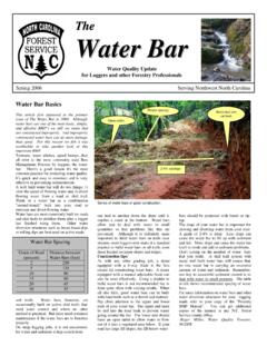
4 Caption text explains important should use these Erosion Control structures as pairs, picking one from each column to successfully Control Runoff and Erosion :Controlling RunoffBroad-based dipCheck DamCross-drainInside DitchlineTurnout (wing ditch)WaterbarCapturing SedimentBrush barrierHay or straw baleSediment pit or silt trapSilt fenceSuggested Spacing Ranges for Erosion Control StructuresSlopeGrade(%)Broad-based dipsTurnoutsCross-drains (Ft)Waterbars(Ft)20+16-2011-156-100-560- 40100-60140-100180-140250-18040-3060-408 0-60100-80120 -100 This table may first appear to be backward. But, it is laid out this way to remind you that steeper slopes usually require closer spacing between Erosion Control structures. Following this pattern of closer spacing along steeper slopes will help you slow it down and spread it out. 3-5 Erosion and Runoff ControlNorth Carolina Forestry BMP Quick Reference Field Guide3-6 Erosion and Runoff ControlNorth Carolina Forestry BMP Quick Reference Field GuideBroad-based dipSide view of a broad-based dip.
5 -- It is a gentle, rolling drainage structure excavated into the roadbed. -- Proper angling outwards promotes drainage of the road surface in a controlled manner. -- Outlet is stabilized with large stone. -- Dip is excavated completely across the road surface and is angled at nearly 90 degrees to the direction of the road so Runoff will easily drain off the The reverse-grade hump is packed down firmly and capped with crushed stone. iginOral GradeNew grade with dip3-7 Erosion and Runoff ControlNorth Carolina Forestry BMP Quick Reference Field GuideBroad-based dipThe long sloping grade of this mountain road is divided intoshorter sections with broad-based Broad-based dip is located underneath the rear wheels of the Road surface is stabilized with Roadside edge is well vegetated with Silt fence is installed at the outlet of the broad-based dip to help filter any sediment in the and Runoff ControlNorth Carolina Forestry BMP Quick Reference Field GuideBrush barrierCheck damBrush barrier is situated along the crest of the roadbed to capture sediment before it can move downslope.
6 (arrow)The brush pile should tightly conform to the ground dams can be made of large stones, tightly stacked within a turnout or along a roadside to slow Runoff and capture sediment. Erosion blankets can help reduce Erosion potential. Multiple check dams may be needed to Control Runoff speed, as shown and Runoff ControlNorth Carolina Forestry BMP Quick Reference Field GuideCheck damCross drainCAUTION: Clean out accumulated sediment. Investigate why so much sediment is being produced. More check dams or turnouts are needed further extends past the road travel surface. Pipe is installed diagonally through the road to promote and Runoff ControlNorth Carolina Forestry BMP Quick Reference Field GuideCross drain Cross drains remove water from within an inside ditchline. Install cross drains diagonally, at a slight downslope grade through the roadbed to promote drainage.
7 Protect the inlet and outlet from scouring or eroding. Extend the pipe well beyond road travel surface. Stabilize the outlet area. Keep debris from building up on the inlet and cross drains should not be drains can require frequent maintenance to remain effective. An out-sloped road that does not need either cross drains or inside ditchlines may be a cheaper long-term solution for permanent :X3-11 Erosion and Runoff ControlNorth Carolina Forestry BMP Quick Reference Field GuideHay / straw bales (Illustration provided with permission and courtesy of the Maine Forest Service.)Set the bales so their bottom conforms tightly against the ground surface. Stagger joints between the bales, like bricks. Secure the bales to the ground as needed. Stakes or wire fencing may be : Hay / straw bales are for temporary use. They will not last for a long period of and Runoff ControlNorth Carolina Forestry BMP Quick Reference Field GuideInside ditchlineThis inside ditchline appears to be well maintained, (arrow) but groundcover should be applied to the ditchline is quickly eroding and becoming a gully.
8 The road surface needs grading and groundcover vegetation. Turnouts or check dams are needed in the ditchline to Control the Runoff . 3-13 Erosion and Runoff ControlNorth Carolina Forestry BMP Quick Reference Field GuideSediment pit / silt trapThis pit is positioned correctly, with a shallow broad-based dip in the road to direct Runoff into the pit. The pit head-wall should be reinforced with stone, or sloped back to prevent the pit wall from caving shallow silt trap can hold a small amount of Runoff and sediment. A series of similar silt traps could work well along a road, skid trail or around a log and Runoff ControlNorth Carolina Forestry BMP Quick Reference Field GuideSilt fence (Illustration provided with permission and courtesy of the Maine Forest Service.)Bury at least the bottom 6 to 8 inches of the silt fence along the upslope side.
9 Securely stake the downslope side of the silt fence to keep it upright and : Silt fence is for will not last over a long period of (%)0 to 22 to 55 to 1010 to 2020+Max. Slope Lengthbetween Fence Rows (feet)100755025153-15 Erosion and Runoff ControlNorth Carolina Forestry BMP Quick Reference Field GuideSilt fenceThe base of this silt fence is not buried. Only a few pieces of wood are holding it down. Heavy Runoff can easily wash underneath the fencing, taking sediment into the creek behind it. Avoid sharp turns when laying out and staking a silt fence. These can be weak points that are easily need to bury at least 6 to 8 inches of the bottom of the silt fence securely in the soil, so Runoff and sediment will not seep underneath. The buried flap should point towards the direction that the Runoff is coming :3-16 Erosion and Runoff ControlNorth Carolina Forestry BMP Quick Reference Field GuideTurnout (wing ditch)Turnout on a closed skid trail with a waterbar installed to direct Runoff into the turnout.
10 Note the additional waterbars further downslope on the turnout (wing ditch) along the road carries Runoff gathered from the road surface into a filter area. Note the hump in the road to direct Runoff into the wing and Runoff ControlNorth Carolina Forestry BMP Quick Reference Field GuideTurnout (wing ditch)Turnout is installed at the crest of the grade-change on this road. Runoff is turned off the road by a shallow collects in this deep turnout at the bottom of a road grade, at the end of a curve in the and Runoff ControlNorth Carolina Forestry BMP Quick Reference Field GuideWaterbarsA waterbar is somewhat like an angled speed bump that is installed diagonally across closed roads, skid trails or firelines. Waterbars are a good choice for controlling Erosion and Runoff , but can be tricky to correctly construct and install.