Transcription of South Kaibab Trail - National Park Service
1 Grand Canyon National park Service Department of the Interior Grand Canyon National park Arizona South Kaibab Trail Hikers seeking panoramic views unparalleled on any other Trail at Grand Canyon will want to consider a hike down the South Kaibab Trail . It is the only Trail at Grand Canyon National park that so dramatically holds true to a ridgeline descent. But this exhilarating sense of exposure to the vastness of the canyon comes at a cost: there is little shade and no water for the length of this Trail . During winter months, the constant sun exposure is likely to keep most of the Trail relatively free of ice and snow.
2 For those who insist on hiking during summer months, which is not recommended in general, this Trail is the quickest way to the bottom (it has been described as "a Trail in a hurry to get to the river"), but due to lack of any water sources, ascending the Trail can be a dangerous proposition. The South Kaibab Trail is a modern route, having been constructed as a means by which park visitors could bypass Ralph Cameron's Bright Angel Trail . Cameron, who owned the Bright Angel Trail and charged a toll to those using it, fought dozens of legal battles over several decades to maintain his personal business rights.
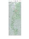
3 These legal battles inspired the Santa Fe Railroad to build its own alternative Trail , the Hermit Trail , beginning in 1911 before the National park Service went on to build the South Kaibab Trail beginning in 1924. In this way, Cameron inadvertently contributed much to the greater network of trails currently available for use by canyon visitors. Locations/Elevations Mileages Rim (7260 ft / 2213 m) to Cedar Ridge (6120 ft / 1865 m): Cedar Ridge (6120 ft / 1865 m) to Skeleton Point (5220 ft / 1591 m): Skeleton Point (5220 ft / 1591 m) to the Tipoff (4000 ft / 1219 m): Tipoff (4000 ft / 1219 m) to Bright Angel Campground (2480 ft / 756 m): Rim (7260 ft / 2213 m) to Bright Angel Campground (2480 ft / 756 m).
4 Mi ( km) mi ( km) mi ( km) mi ( km) mi ( km) Maps Minute Phantom Ranch Quad (USGS) Sky Terrain Trails Map, Grand Canyon (Sky Terrain) Trails Illustrated Map, Grand Canyon National park ( National Geographic) Water Sources There is no water on the South Kaibab Trail . From early May to mid-October there is water near the trailhead (from a spigot near the bus stop). Potable water is available year round at Bright Angel Campground, however, please note that due to occasional pipeline breaks water at Bright Angel Campground is not guaranteed: bringing an alternative form of water treatment, such as iodine tablets or a water filter, is essential.
5 During hot weather, take at least 4 liters of water. Campsites At-large camping is not permitted on Corridor Trails; visitors must camp in designated campgrounds. Along the South Kaibab Trail , the only camping option is at Bright Angel Campground (CBG) located immediately adjacent to the Colorado River at the bottom of the canyon. Trailhead Access The South Kaibab Trail is located near Yaki Point. Due to the popularity of this area and extremely limited space, parking is not permitted at the trailhead. Hikers must use the park 's free shuttle bus system to reach the trailhead.
6 Every morning, three hiker express buses leave from the Bright Angel Lodge and then from the Backcountry Information Center (times vary depending on the month). Otherwise, hikers will need to take the village bus (Blue Line) to Canyon View Information Plaza and transfer to the Orange Line. EXPERIENCE YOUR AMERICATM Trail Description When camping at Bright Angel Campground, many hikers prefer to hike down the South Kaibab Trail and up the Bright Angel Trail . Though the South Kaibab Trail has an almost identical maximum grade compared to the Bright Angel, it is more consistently sloped but does not have water or shade.
7 The hike down South Kaibab Trail typically takes 4-6 hours. The Trail begins with a series of tight north facing switchbacks. This is where ice will most likely be encountered during the winter months. After these initial switchbacks, the Trail traverses a west facing slope until reaching the top of the Coconino Sandstone and the aptly named Ooh Ah Point (the first panoramic view of the canyon). From here, the Trail transitions to the dominant ridgeline, descending on its east and west sides before reaching Cedar Ridge. There are pit toilets at Cedar Ridge, but no water or emergency phone.
8 From Cedar Ridge, the South Kaibab Trail traverses below O'Neill Butte without a single switchback to Skeleton Point. At three miles from the rim, Skeleton Point is the maximum distance recommended for a day hike. The Trail goes directly off the end of Skeleton Point and here, where the Trail has been blasted directly out of the limestone cliffs, hikers will encounter the most dramatic sense of exposure. The Trail descends rapidly via a series of switchbacks to the Tonto Platform and Tipoff. There are pit toilets and an emergency phone at Tipoff, but no water.
9 For hikers who will be utilizing the Tonto Trail to the east or west, the intersection is located fifty feet or so up- Trail from the pit toilets. Below Tipoff, the South Kaibab Trail loosely follows the course of an earlier Trail called the Cable Trail (built in 1907 to accommodate access to the old cable car system across the river that existed before construction of the present suspension bridge). Vestiges of this earlier Trail can be seen as the South Kaibab Trail descends toward the Colorado River. Access to Bright Angel Campground is via the black bridge (built in 1921).
10 Important Notes Grand Canyon is, above all else, a place of extremes. It is necessary to take appropriate precautions depending on seasonal variations in Trail conditions. During winter months, the series of tight switchbacks near the top of the South Kaibab Trail will be icy for days or even weeks after a snowstorm. For hikers who insist on entering the canyon from May to September, it is critical to begin hiking well before dawn or in the late afternoon: Success depends upon staying off the Trail between 10 in the morning and 3 in the afternoon (average descent time is 4 to 6 hours).