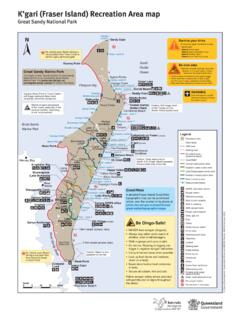
Transcription of Springbrook Inset Maps - Parks and forests
1 Walking tracks and information Page 1/3. Springbrook national park Detailed walks information page 2; Safety and Restricted Access Areas page 3. Map 1 Purling Brook Warringa Pool Legend for maps national park Restricted access area 2 Creek Springbrook national park Sealed road Walking track Littl e Ner Gold Coast Hinterland an g Great Walk Cr Private access eek 1. (W. State boundary es tB. 1 Purling Brook Falls circuit ran 1. ch). 2 Warringa Pool track 3 Buliya-Buliya jagun Tanninaba Falls boardwalk 1 4 Canyon lookout Cam 5 Twin Falls circuit Kuralboo Street p Cr eek Purling Brook Falls 6 Warrie circuit western lookout 7 Goomoolahra Falls Gwongorella picnic area lookout track 8 Boojerahla lookout Sp Purling Brook Falls 9 Best of All lookout track rin Gwongorella picnic area map eastern lookout gb can be found on the Maps 10 Natural Bridge track ro and resources page.
2 Go to Purling Brook Falls ok 11 Cascades track ad Ro Ro To The Settlement ad Brook ad Bridge tr y camping and Ro State of Queensland. Queensland Parks and Wildlife Service. MA972 February 2022. s picnic areas re Scale Waterfall yds Fo ng 0 250 500m r li Pu Llo Cliff line Information Map 2 The Canyon Wi-Fi access To Purling Brook Falls Meeting of the waters Parking h). Old School Road nc ra tB. as Toilets Gauriemabah place of stories (E. ek Springbrook Wheelchair access 3. e national park Cr (may require assistance). an g Poondahra Poonyahra N er Walking track tle Lit Falls Falls Gooroolba 6 Lookout (with handrails). Falls Picnic table 6. Mu ndora C.
3 Sheltered picnic area Ngarri-dhum Barbecue electric k To Best of ree ree All lookout Falls Pathogen control station ll C. k 5. y-u See Inset Augmented reality Bo Map 3 experience Sp Access prohibited Canyon lookout Kadjagooma rin gb Falls 4 6. ro ok Boojerahla Ro The Canyon lookout 5. ad B o y Ull 8. Goomoolahra 7. R oad Ee Falls Rainbow -ju ng Goomoolahra Falls Cr ee picnic area k Check park Alerts Tallanbana Goomoolahra ( ). Twin lookout for the latest on access, Falls closures and conditions. Scale 0 250 500 750m Walking tracks and information Page 2/3. Map 3 Map 4 Natural Bridge section Walking track classifications d Canyon To Nerang Grade 1 track Roa Ne lookout Ca on ve Flat, even surface with ra n C ree 4.
4 R Sta t i k no steps. Suitable g . ay ew No 10. Mu pr th for wheelchairs with On iva rou rw te gh assistance. ate One w pr op roa illum bah Ro ay er d e ty p Tallanbana Grade 2 track Re Formed track. May have Repeater gentle hills and some steps. Station AR. ad Ba thro u g All junctions sign-posted. no ker 9 Best of All No previous bushwalking s R ro Scale experience required. lookout 0 250m To Murwillumbah oa ad . h d AR Grade 3 track Formed track. May have New South Wales short steep hill sections, Scale Map 5 Mount Cougal section a rough surface and many 0 1 2km rrumbin Cree d steps. Cougal Cascades k R oa Cu and picnic area Reasonable level of fitness To Currumbin and some bushwalking experience recommended.
5 Thefts have occurred in Grade 4 track this park . Car crime is a problem Rough track. May be long even in Springbrook national park . and very steep with few Help us STOP this problem. Remains of directional signs. bush sawmill 11. Remove all valuables this k Moderate fitness level ee includes garage remotes. Cu rr u Cr mbin with previous bushwalking Lock your car. Scale experience strongly 0 250 500m Remove your keys. recommended. Walks on page 1 maps Track Return distance and Walking Coloured track code Track name Map and track starting point grade direction time as shown on maps Map 1 Gwongorella picnic area 1 Purling Brook Falls circuit 4km (best walked clockwise) 2hr at the end of Forestry Road 6km (best walked clockwise Map 1 Gwongorella picnic area then 2 Warringa Pool track from Gwongorella picnic area; 3hr branching off the Purling Brook Falls return same way) circuit Map 2 Gauriemabah place 3 Buliya-Buliya jagun 100m 5min boardwalk of stories Map 2 Canyon Parade (take 4 Canyon lookout 30m 5min Boy Ull Road off Springbrook Road).
6 2hr Map 2 Tallanbana 5 Twin Falls circuit 4km 2hr Map 2 Canyon lookout 14km 5 6hr Map 2 Tallanbana 6 Warrie circuit 14km 5 6hr Map 2 Canyon lookout Map 2 Goomoolahra picnic area, 7 Goomoolahra Falls 250m 10min lookout track end of Springbrook Road Map 2 Goomoolahra picnic area, 8 Boojerahla lookout track 450m 20min end of Springbrook Road Walks on page 2 maps 9 Best of All lookout track 600m 30min Map 3 End of Repeater Station Road 10 Natural Bridge circuit 1km (best walked clockwise) 1hr Map 4 Natural Bridge car park Map 5 Cougal Cascades car park 11 Cascades track 1hr and picnic area Walking tracks and information Page 3/3. Adventure safely Walk in small groups, never Tread softly Don't feed the wildlife.
7 Feeding Make your visit memorable for all alone in case someone needs Help maintain this pristine native animals may cause poor the right reasons. to go for help. Always keep your environment here's how: health and sometimes death. walking party together. Leave your pets at home. Stay on the tracks and pay Be aware mobile phone Take all rubbish with you Domestic animals are not attention to safety signs and reception may be poor in (including food scraps, cigarette permitted in national Parks . do not enter restricted access places don't rely on your butts and hygiene items). areas. phone, print or download a Help stop the spread of harmful For all emergencies call Take care near cliff edges, map before you visit.
8 Organisms wash your boots at Triple Zero (000). especially when using Take warm clothing and a the pathogen control stations. Mobile phone coverage is not binoculars or cameras. raincoat. The plateau can be up Bush hygiene keep it clean! available in many of Queensland's Never dive or jump into creeks to 5 C cooler than the lowland There are no toilets away from Parks and forests . If there is no or pools water depth may and is wetter on average picnic areas, so take care with coverage on any mobile network, be shallow or hide submerged receiving up to 3,000mm of rain sanitation and hygiene and you will not be able to reach the objects. each year.
9 Don't pollute the natural water Emergency Call Service via a Pack drinking water or supplies. mobile phone. A Person Locator Leave plenty of time to reach sterilisation tablets safe Be frog friendly please don't Beacon is recommended where your destination and always drinking water is not provided disturb or remove rocks or mobile coverage is not available keep your walking party in the park . trample vegetation near creeks. or on longer walks such as the together. Never start long walks Warrie circuit. after midday. Carry a first-aid kit and use Swimming is not recommended Let somebody know where you insect repellent for ticks and in the park 's creeks as it can are going, plan to return, and leeches.
10 Harm wildlife and pristine what to do if you're late. aquatic ecosystems. For your safety Purling Brook Falls Do not enter the restricted access areas surrounding Cave Creek Restricted Access Area in Natural Bridge section and the top and base of Purling Brook Falls located on the Springbrook plateau. From car park Warringa Stay on formed tracks and behind barriers at all times. and Gwongorella Pool day-use area To car park and Do not go beyond markers showing this symbol. Gwongorella day-use area or The Settlement camping area Natural Bridge Restricted Access Area Purling Brook Creek Ca ve Creek Private access No through road t ui rc ci ls al kF.