Example: bankruptcy
Storm Dennis - Met Office
Storm Dennis Storm Dennis was the fourth named storm of the 2019/2020 season. Arriving one week after storm Ciara, Dennis brought heavy and persistent rain across much of the UK – especially Wales and western England. Western upland parts of the UK received 50 to 100mm or more of rain falling on saturated ground.
Tags:
Information
Domain:
Source:
Link to this page:
Documents from same domain

Flooding in Cumbria December 2015 - Met Office
www.metoffice.gov.ukDistrict, Cumbria - November 2009 and Floods in Carlisle - January 2005 Cumbria flood events. The rain-radar imagery below from 0900 GMT 4 December to 1200 GMT 6 December shows the fronts associated with storm Desmond bringing heavy rain to western Scotland, north-west England and much of

UKCP18 Factsheet: Sea level rise and storm surge
www.metoffice.gov.ukLeft panels: time series of mean annual sea level change for the UK compared to present (1981-2000) for a high emissions scenario (RCP8.5). The bold lines are the median change and the shaded area the likely range (5th-95th percentile). The dotted line shows the range across low to high emissions scenarios (RCP2.6, RCP4.5 and RCP8.5).

UK Climate Projections: Headline Findings
www.metoffice.gov.ukRepresentative Concentration Pathways (RCPs)’. This headline findings document is primarily intended to underpin messages, from the UKCP suite of tools, for the interested public and media. It also serves as a summary for users of UKCP18, although they are

North West England & Isle of Man: climate - Met Office
www.metoffice.gov.ukThe Lake District in Cumbria includes Scafell Pike (978 metres), the highest mountain in England, and Windermere, the largest lake. To the north and NE, there is further low ground (below 60 metres) in the Vale of Eden and the Solway Plain, close to Carlisle. Most of the Isle of Man consists of a central mountain mass

Microclimates - Met Office
www.metoffice.gov.ukThe effect of this is that plants and animals are often different from those at low levels. Data comparison of Princetown, Plymouth and Teignmouth ... The reason for this is due, in the main, to the altitude and their proximity to the prevailing wind of these locations. Princetown, high up on Dartmoor, is at an altitude of 453 metres above

Beaufort - Met Office
www.metoffice.gov.uk(32.7 metres per second) or more – that is, the wind speed averaged over a period of 10 minutes. The additional five points extended the scale to 118 knots (61.2 metres per second), with Force 12 referring only to speeds in the range 64 to 71 knots (32.7 to 36.9 metres per second). However, Forces 13 to
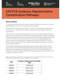
UKCP1 uidance Representative Concentration Pathways
www.metoffice.gov.ukRepresentative Concentration Pathways (RCPs) are a method for capturing those assumptions within a set of scenarios. The conditions of each scenario are used in the process of modelling possible future climate evolution.

Midlands: climate - Met Office
www.metoffice.gov.ukIt includes the Severn and Avon valleys, with their rivers flowing to the south, and the valley of the eastward-flowing Trent in the northern part of the area. Between these 3 valleys is a plateau of altitude 100 - 250 metres, with industrial Birmingham and the Black Country. The Avon and

GetMet - Weather and climate change - Met Office
www.metoffice.gov.ukreport with no human intervention METAR – aviation routine report, SPECI – selected special (not from UK civil aerodromes) Station four-letter indicator AUTO METARS may only be disseminated when an aerodrome is closed or at H24 aerodromes, where the accredited met. observer is on a CAA approved overnight duty break. Users are
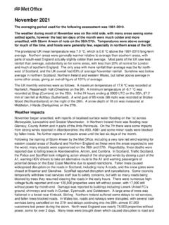
NCIC Monthly Summary - metoffice.gov.uk
www.metoffice.gov.ukfizzling out; parts of the Midlands became brighter for a time. 16th to 20th Though remaining mild for now, the next few days began to become less settled. Mist and fog affected many southern areas on the 16th, otherwise after a bright start in the south-east cloud increased everywhere with patchy rain or drizzle in many places.
Related documents

Friday - Fire Danger Conditions Update February 10, 2022
www.weather.govMaximum Wind Gusts Friday afternoon 25 Weather Forecast Office Topeka, KS Issued Feb 10, 2022 4:33 AM CST Af .NWSTopeka pžrjor Em" r rižj weather.gov/top