Transcription of The Needles Roads and Trails - National Park Service
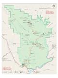
1 CanyonlandsNational park Department of the InteriorCanyonlands National ParkNeedles District Trails and Roads211 ISLAND IN THE SKYTHEMAZEB rown BettyRapidsConfluenceThe SlideTHE LOOP GreenRiverColorado DruidArchB E E F B A S I N T H E G R A B E N S LOWER RED LAKE CYCLONE CANYON DEVILS LANE SQUAWLOST CANYON DAVIS CANYON LAVENDER BIG SPRINGCHESLERPARKCANYONS A LTC R E E KC A N Y O NC A N Y O NH O R S ECANYON I N D I A N C R E E K C A N Y O NC A N Y O NELEPHANT NORTHT owerRuinFortressArchAngel ArchUpper JumpKirk CabinCleftArchCathedral ButteBobbys HoleCastleArchPaulBunyansPottyPermit requiredfor vehicle entryRoad endsat park boundaryPermit requiredfor vehicle entryNo TrailAcross RiverFrequently impassable for4-wheel-drive 5 Cathedral Butte to18mi29kmNeedles Visitor Center to34mi53km9 miles from to park boundary21115 miles from to park Spring CanyonOverlookColoradoRiver OverlookWooden ShoeArch OverlookSquaw FlatNeedles Outpost(Privately owned)HamburgerRock(BLM)VisitorCenterEle phantHillBasin Road JointTrailLockhartPotholePointRoadside RuinCave SpringSlickrockDevilsKitchenBobbyJoHorse hoofNew BatesWilsonPeekabooCP4CP2CP5CP3CP1DP1EC1 EC2EC3SQ1SQ2LC3LC2LC1BS1BS2SC3SC4SC2SC1 Red Lake/GrabensButler/West Side CanyonsDavis/LavenderSalt/HorseNeedles NorthOverlook/Paved roadHigh-clearance,4-wheel-drive roadHiking TrailUnpaved2-wheel-drive roadLocked gatePicnic areaRanger stationDrinking WaterSelf-guiding trailDeveloped CampgroundRapidsBackcountry Vehicle CampDesignated Backpacking SiteBackcountry Trailhead ParkingNameName of Backpacking ZoneAt-large Backpacking ZoneNOTE: White shading within Canyonlands National park indicates areas with designated site camping byCanyonlands Natural History Association12/17 Hiking TrailsOver 60 miles of interconnecting Trails present hikers with spectacular canyon scenery.
2 Some of the more common routes are described below. Trails traverse a mixture of slick-rock benches and sandy washes, and some may require negotiating steep, rocky passes with drop-offs, narrow areas and ladders. Water sources are unreliable; carry all that you will need. Trails are marked with cairns (small rock piles) and signs at HILL TRAILHEAD Chesler park Viewpoint6mi/10km, 3-4 hrs round tripThis popular trail leads across to a pass overlook-ing a scenic expanse of desert grasses and shrubs surrounded by sandstone park Loop / Joint Trail11 mi/18 km, 5-7 hrs round tripThis loop travels beyond the viewpoint described above, providing great views of the Needles . The southern portion, called the Joint Trail, winds through deep, narrow fractures in the rock. A short segment follows the four-wheel-drive Arch11 mi/18 km, 5-7 hrs round tripThis trail offers one of the most spectacular views in the Needles . It follows the first part of the Chesler park trail, then branches off to travel along the bottom of Elephant Canyon through deep sand and loose rock.
3 The last .25 mile at the upper end is steep with 1 ladder and some SPRING CANYON TRAILHEAD Confluence Overlook10 km, 5-6 hrs round tripUnlike other Needles hikes, this trail traverses dry, open country along the northern edge of the geologic faults that shaped the Needles . Trail ends at a cliff overlooking the junction of the Green and Colorado rivers 1,000 feet FLAT LOOP A TRAILHEAD Big Spring Canyon to Squaw mi/12 km, 3-4 hrs round tripA great introduction to the landscape of the Needles , connecting two canyons for a loop across varied terrain. The route between the canyons climbs steep grades that are dangerous when wet and may make people with a fear of heights Spring Canyon to Elephant mi/17 km, 4-6 hrs round tripThis loop features extended hiking on slickrock benches and mesa tops overlooking canyons. Excellent views of sheer cliff walls and other rock formations. Two ladders must be climbed in the pass between the Canyon to Lost mi/14 km, 4-6 hrs round tripAnother wonderful loop hike with some difficult sections climbing between the two canyons.
4 Riparian areas in both canyons attract birds and other wildlife. Route in Lost Canyon passes through dense vegetation and may be very wet. One ladder must be km, 5-6 hrs round tripTrail crosses both Squaw and Lost canyons on its way to Salt Creek Canyon, passing along high slickrock benches with spectacular views. Steep slopes and nearby cliff edges make this a challeng-ing route. Two ladders must be climbed. Prehis-toric rock art panel may be seen at the end of the trail near Peekaboo HIKESS hort on time? Four short, self-guiding interpretive Trails highlight various aspects of the area's cultural and natural history. Trail guides are available in the visitor center and at trailheads for a nominal Ruin .3 mi/.5 km, 20 minutes Easy trail. Leads to an ancestral Puebloan mi/1 km, 45 minutes Two ladders. Leads to historic cowboy camp and prehistoric Point. 6 mi/1 km, 45 minutesUneven surface. Leads to pothole communities, views of the mi/4 km, 2 hoursUneven surface.
5 Several viewpoints and sometimes bighorn RoadsOver 50 miles of challenging backcountry Roads access campsites, trailheads and park attractions. All vehicles and bikes must remain on designated Roads . All of these Roads require high-clearance, four-wheel-drive vehicles. Drive carefully: the risk of vehicle damage is great and towing expenses typically exceed $1, Hill D*One of the most technical four-wheel-drive Roads in Utah, Elephant Hill presents drivers with steep grades, loose rock, stair-step drops, tight turns and backing. Over the hill, equally challenging Roads lead to various campsites and trailheads, as well as to BLM lands south of the park . Challeng-ing mountain biking. Colorado Overlook D*Moderate road, good for mountain bikes. There are large rocks and stair-step drops in the last miles which visitors may avoid by parking on the road (leave room for others) and walking to the overlook. Outstanding views of the Colorado River Canyon. Unprotected overlook; use cau-tion.
6 No vehicle Canyon / Peekaboo DPermit required for day and overnight use. Roads travel along canyon bottoms where deep sand, deep water and quicksand are common. Too sandy for mountain bikes. At Peekaboo, vehicle campsites are available and prehistoric rock art may be seen. Horse Canyon road leads to several arches and Tower Canyon DPermit required for day use. Road follows a canyon bottom where deep sand, deep water and quicksand are common. Too sandy for mountain bikes. There are two major creek crossings with steep banks. Arches and ancestral Puebloan gra-naries may be viewed from the road. No vehicle camping inside the Reservationseservation Office2282 Resource , UT 84532 Phone: (435) Protect Yourself Drink at least one gallon of water each day. Always carry a topo map, adequate clothing, and a flashlight. Remain in one place if you become lost or separated from a group. Never cross a canyon that is flooding. During lightning storms, avoid lone trees, cliff edges and high ridges.
7 Return to your vehicle if possible. Be careful near cliff edges, especially when rock surfaces are wet or icy. Protect Your park Pets are not allowed on hiking Trails or on four-wheel-drive Roads , even in a vehicle. Do not enter, alter, damage or deface archeo-logical sites. Do not collect artifacts. Vehicles and bikes must stay on Roads . ATVs and OHVs are not permitted. Protect cryptobiotic soil crusts by staying on Trails and Roads . Permits are required for all overnight backcountry YOUR AMERICAFor More InformationCanyonlands National Park2282 SW Resource , UT 84532(435) Media @CanyonlandsNPS