Transcription of THE UPPER SALMON RIVER - Bureau of Land Management
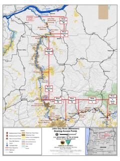
1 THE UPPER SALMON RIVERBOATING GUIDE, EAST-CENTRAL IDAHOI daho Department of Fish and Game | Forest Service | Bureau of land Management !!!!!!!S1S2S3S4S5S6S7S8S9S10S1 1S12S13S14S15 IDAHOMapLocationELLISCHALLISCLAYTONSTANL EYCARMENSALMONNORTHFORK SALMON RiverINDEx AND LOCATION MAPSALMON TO NEWLAND RANCH milesMcKIM CREEK TO SALMON milesTHOMPSON CREEK TO McKIM CREEK milesSTANLEY TO THOMPSON CREEK milesCover photography Chad CaseUPPER SALMON RIVERBOATING GUIDE, EAST-CENTRAL IDAHOI daho Department of Fish and Game SALMON Regional Office99 Highway 93 North SALMON , Idaho 83467208-756-2271 Sawtooth National Forest370 American Avenue Jerome, Idaho 83338208-423-7500 Bureau of land Management Idaho Falls District 1405 Hollipark DriveIdaho Falls, Idaho 83401208-524-7500 Bureau of land Management Challis Field Office 721 East Main Avenue, Suite 8 Challis, Idaho 83226 208-879-6200 Bureau of land Management SALMON Field OfficeSalmon-Challis National Forest1206 S.
2 Challis StreetSalmon, Idaho 83467208-756-5400 THE RIVER S NAMESAKEThe SALMON RIVER supports three separate species of anadromous fish (fish born in fresh water that migrates to the ocean to mature, then returns to fresh water to spawn). A SALMON s life begins and ends here in the moun-tains of Idaho. Chinook SALMON (Oncorhynchus tshawytscha) and sockeye SALMON (Onrcorhynchus nerka) travel nearly 900 miles to reach the spawn-ing areas in the Stanley Basin and, unlike steelhead (Oncorhynchus mykiss), die after spawning. All three species, as well as numerous other fish that make the SALMON RIVER their home need clean, oxygen-filled water to survive. Dozens of wildlife and bird species also depend on the clean water and robust riparian zone of the SALMON RIVER to survive, which is just one of many reasons to take care of this resource. Chinook SALMON spend one year in fresh water before they make the long journey to the ocean.
3 After one to three years in the ocean, they are big and mature, and head back to their spawning grounds. As they make their way to the mountains their bodies change, growing a hooked jaw and large, sharp teeth. Joseph TomerelliSockeye SALMON also undergo drastic change on the long journey from the ocean to the SALMON RIVER . The males grow a hump on their back, their jaws become hooked, sharp teeth grow, and they turn from entirely bright blue-silver to bright red bodies with dark green heads. Sockeye spawn in RIVER systems that contain lakes. Their smaller relative, kokanee, live their entire lives in the high lakes and Chinook SALMON (female) Joseph Tomerelli Sockeye salmonivCONTENTS iiiiv12467101213145051back coverIndex and Location MapThe RIVER s NamesakeWhitewater ClassesIntroductionLaws and RequirementsSalmon Habitat Restoration Safety EthicsSteelheadLegendThe HeadwatersRiver Maps and InformationReferencesIdaho Birding ChecklistEmergency ContactsAdministrative OfficesOutfitters and GuidesvWHITEWATER CLASSESR apid ratings are a general guide to relative difficulty.
4 Severe weather conditions, extreme water levels and remote locations all contribute to the danger of white water boating. Changes in water levels or flows cause variations in rapid difficulty. Scout any rapids you are not familiar with, and understand and respect your limitations. Class I Small waves, passages clear, no serious II Medium-sized, regular waves; passages clear, some maneuvering may be IIIW aves are numerous, high and irregular; rocks, eddies, narrow passages; scouting usually IV Powerful, irregular waves; boiling eddies; dangerous rocks; congested passages; precise maneuvering required; scouting V Exceedingly difficult; violent rapids often following each other without interruption; big drops, violent current, scouting mandatory, but often VI Limit of navigability, generally considered Streamflows real-time stream flows for most rivers in Idaho, water temperatures at some gauging stations and annual hydrograph charts that show when rivers typically get peak spring flows from the above SALMON RIVER flows 425 miles through Idaho from its headwaters near Galena Summit in the Sawtooth National Recreation Area to its confluence with the Snake RIVER on the Oregon border.
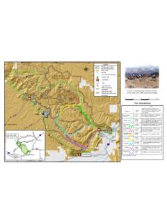
5 It drains 14,000 square miles and drops more than 7,000 feet. The SALMON RIVER has three distinct recreational segments: the UPPER SALMON (Stanley to North Fork), the Main SALMON (Corn Creek to Carey Creek), and the Lower SALMON (White Bird to the Snake RIVER confluence). This guidebook covers the 150 RIVER miles from the Sawtooth Fish Hatch-ery in Stanley to North Fork and Newland Ranch. The UPPER SALMON RIVER provides a variety of boating opportunities. Between Stanley and Clayton the RIVER bounces through several classified rapids and is a favorite stretch for white water enthusiasts. Most trips begin below the Class IV Sunbeam Dam rapid taking advantage of Piece of Cake (III) rapid. As the RIVER makes its way towards Challis, the valley broadens and the gradient decreases significantly. Ever changing cottonwood gal-leries pose their own threats to boater safety. From Challis to North Fork, the SALMON RIVER is fairly mellow with Class I riffles punctuated with short canyon features and Class II rapids making this run an ideal beginner stretch.
6 The UPPER section is unique in its combination of easy access and back country scenic quality. The campgrounds and access sites along this corridor host thousands of people each year. Highways 75 and 93 parallel this entire reach, connecting the towns of Stanley, Clayton, Challis, Ellis, SALMON , and North Fork. Major tributaries include Valley Creek, Yankee Fork, East Fork, and the Pahsimeroi, Lemhi and North Fork rivers. Occasionally, boaters navigate some of the SALMON s tributaries. This guide will help you navigate the RIVER and learn about nature. Please note where the north arrow points on each map. land ownership patterns are mixed (public and private lands) and rarely signed, so careful map reading ensures your activities will not impinge upon private property rights. Public and private campgrounds are prevalent along this stretch and accessible from the RIVER as well as the highway.
7 Please be aware that the UPPER SALMON RIVER , while not known for its classified rapids, still requires adequate equipment and skills to navigate AND REQUIREMENTSINVASIVE SPECIES LAWS FOR BOATERSU nder this law, the owner of any non-motorized vessel in Idaho (canoe, kayak, raft, driftboat, etc.) is required to purchase and display Idaho Inva-sive Species Fund (IISF) stickers on their vessel(s) in order to legally launch and operate in Idaho. Inflatable, non-motorized vessels under 10 feet in length are exempt from this requirement in Idaho. Idaho Invasive Species Fund (IISF) : non-motorized example for any boat that is registered in Idaho or another state, and any non-motorized vessel (canoe, kayak, raft, drift boat, etc.). Right: non-resident WATER CRAFTS mall to medium motorized water craft are allowed in this section of the RIVER corridor downstream from Torrey s Hole although it is not common for long distance, through PRIVATE PROPERTYT here is a mix of private, state and federal land in this RIVER corridor.
8 Know where you are on the RIVER and respect the rights of private property own-ers so that boaters can continue to enjoy the RIVER in the AND CULTURAL MATERIALSC ollecting or disturbing archaeological artifacts and historic objects is prohibited by federal SPRINGS Digging, damming, or otherwise altering the natural flow or appearance of hot springs is prohibited by Idaho Code 42-351. IDAHO STEELHEAD RULESA nyone fishing for anadromous SALMON and/or steelhead must have a valid fishing license and SALMON and/or steelhead permit(s) on his/ her must purchase either a non-resident season fishing license and a full season SALMON and/or steelhead permit or a non-resident, 3-day SALMON /steelhead license/permit. Learn the rules on the Idaho Department of Fish and Game website at mussels aquatic invasive species3 RECREATIONAL PLACER MINING IN IDAHOMany people enjoy the challenge of searching for gold in Idaho s streams and rivers by means of recreational mining.
9 The alteration of stream channels by using recreational mining equipment in a stream is regulated in Idaho by the Stream Channel Protection Act. Recreational mining equipment can be any implement that is used to dig, scrape, dredge, or otherwise move stream bed materials from below the mean high watermark in search of minerals. The Stream Channel Protection Act requires that a miner obtain a permit from the Idaho Department of Water Resources (IDWR) before altering any portion of Idaho s stream beds. IDWR regulations do not allow recreational mining in the UPPER SALMON RIVER and its navigable tributaries due to threatened or endangered fish is a misdemeanor in Idaho to alter a stream channel without the IDWR permit or to violate the conditions of the permit. Mineral removal from streams on private lands requires permission or a mineral lease from the owner. For more information, visit Idaho s website at Please note the Sawtooth NRA is closed to all mining including recreational panning and placer ENDANGERED SPECIES ACT OF 1973 The Endangered Species Act (ESA) was signed on December 28, 1973, and provides for the conservation of species that are endangered or UPPER SALMON RIVER Basin is part of the Columbia RIVER Basin home to fish species listed under the ESA as endangered (Snake RIVER sockeye SALMON ) and threatened (Snake RIVER chinook SALMON , Snake RIVER steel-head, Columbia Basin bull trout).
10 These native species occupy, currently reside, or migrate within many miles of streams and rivers. Tributaries used for spawning and rearing along the SALMON RIVER are vitally important. Hundreds of stream miles are designated critical habitat for sockeye SALMON , Columbia Basin bull trout (Salvelinus confluentus), Snake RIVER steelhead and the Snake RIVER Chinook SALMON . Other sensitive species include the westslope cutthroat trout and redband rainbow trout, both native salmonids. For boating restrictions in the Sawtooth NRA during spawning season, please read page 12. Columbia Basin bull trout Joseph TomerelliSALMON HABITAT RESTORATION The UPPER SALMON Basin Watershed Program, coordinated by the Idaho Governor s Office of Species Conservation, helps landowners develop water restoration projects to improve SALMON habitat. The program assists with the permitting process for these projects, oversees the work and monitors the outcomes.