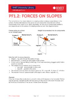
Transcription of Types of Slopes - Haldia Government College
1 Types of Slopes Gentle slope A slope with contour lines spread far apart from each other. This even spacing is maintained in both up and down slope Steep slope A slope represented with contour lines close to each other on a topographical map. Convex slope A slope which becomes progressively steeper downhill. It can refer to an entire slope or part of one. On a map the contour lines will be spaced closer together with a decline in height above sea-level. Concave slope A. slope which becomes progressively steeper uphill. It can refer to an entire slope or part of one. On a map the Contour lines will be spaced closer with an increase in height above sea-level.
2 Tectonic Slopes These are formed through internal forces that result in the folding, warping and faulting of rock masses or layers. Anticlines and synclines, are formed when layers of rock are folded;. while horsts (block mountains). and graben (rift valleys) are formed when blocks of land rise or fall in relation to each other when faulting occurs. Depositional Slopes Deposits of weather material build up to form inclined surfaces, mounds and hills when an agent of erosion ( wind, water or ice) which has lost its energy of motion, lays down its load in a particular place.
3 Examples are alluvial fans, alluvial cones, deltas and sand dunes. slope Elements Crest A small convex-shaped slope , with a thin covering of soil Edge of the hill Convex Thin layer of soil Weathered material removed Freeface / Scarp / Cliff A near vertical slope , more than 80 to the horizontal > 80 to the horizon Layer hard resistant rock Loose material falls to bottom of cliff Cliff retreats parallel to itself Talus / Scree / Debris/Rectilinear slope /constant/uniform A slope with a constant angle, and is formed of eroded material from crest and freeface Accumulates from crest and cliff face Uniform slope Pediment A low-angle concave slope Low angle, concave slope slope is not uniform- steeper close to the talus slope Pediment increases as the slope increases backwards due to scarp recession Model classification of slope form A.
4 Four unit model It was proposed by A. Wood in 1942. a) The waxing slope is the curve over edge of the horizontal surface of the hilltop. It is also called the convex slope or upper wash slope . b) The free face A steep slope or part of a slope formed of bare rock. c) The constant slope is a slope with a uniform angle that did not alter as the slope developed through time. Many constant Slopes only have a very thin cover of rock waste. It usually extends upward to the rock cut slope of the free face d) Waning slope stretches to the valley floor with diminishing angle and is characterized with fine materials.
5 It is also known as pediment, valley floor basement or lower wash slope . Nine unit model (Dalrymple et al. in 1968. ). This was proposed by Dalrymple et al. in 1968 and is a more complex model which relates slope form to the processes of slope formation. The main processes in operation are weathering, through flow and mass movements Unit 1 is Interfluve, 2 is Seepage slope , 3 is Convex creep slope are comparable to the waxing slope . Unit 4 is fall face it is equivalent to the free face. Unit 5 is Constant slope , 6 is Colluvial footslope, Unit 7 is alluvial toe slope are correspond to the constant slope and waning slope .
6 Unit 8 is Channel wall and 9 is Channel bed. 1. interfluve: divide area characterized by 6. colluvial foot slope : Depositional largely vertical subsurface water and soil region. Material is further transported movement down slope by creep, slope wash and 2. seepage slope : gently dipping portion subsurface flow. dominated by downward percolation 7. Alluvial toe slope : region of alluvial 3. convex creep slope : upper convex zone deposition ( levee deposits). characterized by creep and terracette 8. Channel wall: removal by corrasion, formation slumping, fall etc. 4. fall face: Cliff face characterized by 9.
7 Channel bed: Down stream transport rapid detachment of material or bedrock of material (weathering limited) exposure. 5. transportational midslope: Active region characterized by mass movement, terracette formation, slope wash and subsurface water action Models of slope evolution Three models of slope evolution have been proposed and widely accepted. 1. slope decline (W. M. Davis, 1899). 2. slope replacement (W. ). 3. slope retreat (L. C. King, 1948). Other models 4. Free face theory (Wood, 1942). Savigear's model slope decline ( Davis New England) upper slope weathers and erodes at faster rate so there is progressive decline of slope angle occurs.
8 Hillslopes have a thick mantle of regolith Parallel retreat (W. Penck): slope angle and lengths remain uniform as the slope retreats parallel to itself. Hillslopes are essentially free of sediment. Parallel retreat occurs where underlying strata are protected by a resistant cap rock, such as a layer of sandstone, limestone, or lava. Failure of the caprock occurs only when erosion has removed the weaker rock supporting it. Parallel retreat is responsible for the classic stepped topography of the Colorado Plateau, and the formation of flattopped buttes, mesas, and pinnacles.
9 slope replacement (King) steep slope is progressively replaced by shallower lower slope deposits. The upper slope retreats parallel to itself while replacement of the lower slope forms a pediment. Monument Valley, Utah exhibits some of the best examples of slope retreat Bryce Canyon Utah exhibits slope retreat where weak rocks . are protected by resistant caprock