Transcription of Using scale - Pearson Publishing Ltd - Home
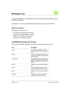
1 Using scaleHere is a simple map. It shows an simple scale has been printed underneath. This kind of scale is called a linescale. Sometimes it is called a line is 10 cm long. Each centimetre represents 1 kilometre. The whole linerepresents 10 how the island is exactly the same width as the line scale . This shows usthat the island is really 10 km are two dots on the map. These represent towns on the island. Measurebetween the two dots with a ruler. They are 7 cm use your ruler to measure 7 cm along the line scale . Start measuring at 0 on the scale . This will show you that the towns really are 7 km apart on far is it across the island at its narrowest point?
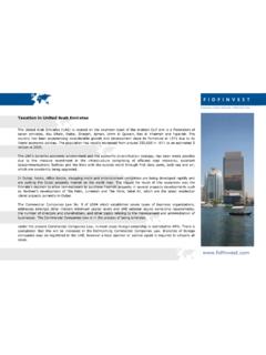
2 Write your answer in Worksheets 1: Geographical Skills4 West seaEast seaThe island Weston EastonNActivitiesLook at this sketch map carefully. Then answer the questions at the bottom of Which road does Oliver live in?_____2 Which road is the school in?_____3 Which other road does Oliver walk along?_____4 Oliver passes the following landmarks on his way to school. Which orderdoes he see them in?The church The library The pond The park The postbox_____5 Find Jo s house. Which landmark will Jo walk past that Oliver will not walkpast?_____Geography Worksheets 1: Geographical Skills19 Wood RoadThe pondWindmillJo s houseOliver s housePond RoadBishop s Close SchoolParkVillage HallLibraryPost BoxChurchShopGreen RoadMain StreetChurch FarmChurch RoadThe GreenHow Oliver gets from home to schoolShowing height on mapsWe measure the height of land above sea level.
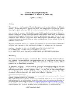
3 Some symbols have beendesigned to show the height of the land. Here are three of them:ContoursThese are lines drawn on a map which join places which are the same are often drawn every 10 metres and have numbers to show how high theland we drew lines around a hillshowing the land that was 10 metres, 20 metres and 30 metres we looked down on the hill we would seethis pattern. This is the contour pattern for heightsThese are small dots. They are often found next to roads onsome maps. Next to the dot is a number. This shows the heightof the land at that road is 62 metres above sea level at this colours or patternscan be used to show theheight of land.
4 Here is Worksheets 1: Geographical Skills3130 m20 m10 m302010 62road KeyOver 30 m 21 30 m 11 20 m 0 10 mWhy does it rain?CondensationWe can see water all around us. We see it in puddles, in rivers and when weturn on a tap. We can also see water when it is solid. We call it ice. Did youknow that water can be a gas? It is invisible. We call it water vapour is found in the air. If air is cooled, someof the water vapour turns into tiny droplets of can prove this by breathing on a window on acold day. The window steams up as the watervapour condensesand the droplets are water vapour in the air condenses, it a lot of water vapour condenses, then it may rain.
5 It often rains in hilly air is carried upand over the hill. Theair gets colder as it risesand this causescondensation. Cloudsare formed and it doesn t rain as muchon the other side of thehill. This area is calledthe rain a line of squares, one for each day of the month. Write the date in eachbox. Tick the box if it rains on that day. Make a cross if it rains for most of theday. At the end of the month, count how many days have no rain, how manyhave some rain and how many have a lot of Worksheets 1: Geographical Skills46rainThe air is colder and water vapour condenses into cloudThe air blows up the hillThe air goes down the other side.
6 It is warmer and drier. Rain shadow 1234567891011121314151617181920212223242 526272829303333335533533 September