Transcription of ZONING SUMMARY - Department of Planning
1 417 East Fayette Street, 8th Floor(410) 396-7526 BALTIMORE CITY Department OF Planning Thomas J. StosurDirectorTTY#: (410) 545-7580 ZONING S UMMARY General B ackgroundThe p urpose o f z oning i s t o p rotect t he g eneral h ealth, s afety a nd welfare o f o ur c itizens a nd t o c reatestability. T his i s d one b y c reating z oning c ategories which a llow c ertain l and a nd b uilding u C ity's Z oning O rdinance was c reated a fter a c omprehensive z oning p lan was a pproved byOrdinance # 1051 i n 1 C ity's a uthority t o c reate z oning i s o utlined i n A rticle 6 6B o f t he S tate C harter.
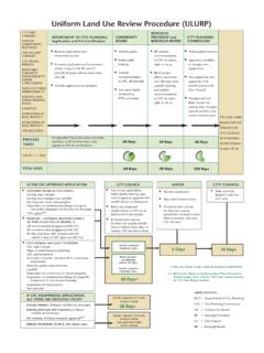
2 The C ity's r egu-lations a lso a uthorize t he B oards a nd C ommissions which make r eports o n z oning i ssues. T he P lanningCommission i s r equired t o r eview a nd make r ecommendations t o t he C ity C ouncil within 1 00 d ays ofintroduction o n a ll z oning c hanges a nd t ext a C ity's Z oning O rdinance s ets f orth f our ( 4) b asic l and u se c ategories a nd l ists t hose u ses a llowed ineach ZONING district. I f a u se i s n ot l isted i t i s n ot a llowed. Each z oning d istrict l ists u ses p ermitted byright, c onditional t o t he B oard o f Municipal a nd Z oning A ppeals ( BMZA) a nd c onditional with t heapproval o f t he C ity C ouncil a nd Mayor ( bills).
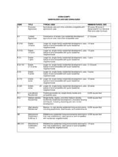
3 The P lanning D epartment s taff makes written r ecommendations o n c onditional u ses r equiring B MZAapproval. S taff makes r ecommendations t o t he P lanning C ommission o n b ills. The C ommission makesrecommendations t o t he C ity C ouncil. The P lanning C ommission i s u nique b ecause t hey a re t he o nly r ec-ommending b ody which h olds a p ublic h earing. All o ther A gencies a nd B oards make written r ecommen-dations b ased s olely o n p rofessional e xpertise. T he L and U se C ommittee o f C ity C ouncil a lso h olds a p ub-lic h earing a nd makes a r ecommendation t o t he C ity C CategoriesBelow a re t he f our ( 4) b asic z oning c ategories ( residential, o ffice-residential, b usiness a nd manufacturing):RESIDENTIALT here a re t en ( 10) r esidential d istricts i n B altimore C ity.
4 "R" i s u sed t o d esignate t hese a reas. T he mainpurpose i s t o meet t he h ousing n eeds o f t he C ity's p resent a nd f uture p opulation, a nd t o p romote t hestability and desirability of residential districts. T hey i nclude b oth s ingle-family a nd g eneral r esidentialdistricts. Basically, t he d ensity i ncreases with t he n umber f ollowing t he " R" d Residential Districts There a re f our ( 4) s ingle-family r esidential c - maximum 5 .9 units p er a cre a llowed; a nd?R-3 - maximum 8 .7 u nits p er a cre a 1992, t he Z oning O rdinance was a mended t o c reate t wo ( 2) l ower d ensity s ingle-family d - maximum 3 u nits p er a cre a llowed; a nd ?
5 R-1B - maximum 2 u nits p er a cre a o f R -1 n eighborhoods i nclude: Te n H ills, H unting R idge a nd G uilford. A p ortion o f was t he f irst a rea d esignated R -1B. R-3 a rea e xamples i nclude A shburton a R EGULATIONSEach z oning c ategory a lso i ncludes b ulk r egulations f or s uch t hings a s h eight, d ensity, f loor a rea r atio,yard s et b acks a nd p arking r equirements. Requests f or v ariance o f t hese r egulations c an b e c onsideredby t he B oard o f Municipal a nd Z oning A t he F lood P lain a nd C ritical A reas r egulations f or t he C ity a re p art o f t he Z oning O rdinance.
6 Theseregulations a re r eviewed a s t he C ity e valuates a z oning o r o ther d evelopment r equest. They a re i mple-mented a t t he t ime t he P lanning D epartment's E nvironmental s taff r eviews p ermits f or p rojects. ForestConservation i s a lso a p rogram i mplemented b y t he P lanning D P LAINB altimore C ity i s a p articipating j urisdiction i n t he N ational F lood I nsurance P rogram. In order for theproperty o wners within B altimore C ity t o b e e ligible f or t he F ederally u nderwritten f lood i nsurance a ndto i nsure t hat minimal n egative i mpacts o ccur i n c ase o f a f lood, the City implements certain ZONING andBuilding C ode r equirements.
7 T he Z oning O rdinance l ists what u ses a re a llowed i n t he f lood a i s a llowed i n t he f lood p lain, in certain cases, pr ovi ded t he s tructure c an b e ele vated abovethe 1 00-year f lood l evel. T he P lanning D epartment h as maps t hat c an b e u sed t o s ee i f y our s ite i s i n aflood plain. I f y our p roperty i s i n a f lood a rea y ou will b e r equired t o a dhere t o t hese s pecial r more i nformation c ontact t he P lanning D epartment a t ( 410) 3 96-5902 o r ( 410) 3 A REA The C ritical A rea Management P rogram i s a S tate mandated p rogram t o a ssist i n p ollution r eduction a ndto e nhance t he q uality o f t he C hesapeake Bay.
8 Every property within 1,000 feet of the shoreline (meas-ured f rom t he 2 ' c ontour l ine) i s i mpacted. If a project within this boundary, a nd d isturbs more t han10,000 s quare f eet o r i ncludes s ubstantial r enovations t o a n e xisting s ite, t hey must meet s pecial r equire-ments f or s torm water management. I f d evelopment o ccurs within 1 00' o f t he s horeline a dditional s pecialrequirements must b e met. Contact t he P lanning D epartment a t ( 410) 3 96-5902 f or f urther i C ONSERVATIONThis i s a S tate mandated p rogram t riggered b y a ny p lan t hat r equires 2 0,000-square f eet o f g rading.
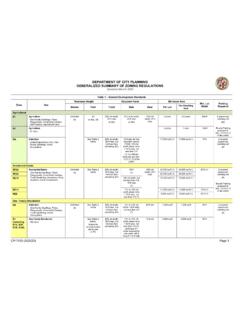
9 I f aproject triggers this criteria, a F orest S tand D elineation ( evaluation o f what e xists o n t he s ite) a nd a F orestConservation P lan ( what i s t o b e r etained a nd what i s t o b e p lanted) i s r equired f or a p roject. For moreinformation contact the Planning Department at (410) Residential Districts There are eight (8) general residential districts. These districts allow a wider variety of housing types. Allof these categories allow for single-family detached dwellings ( per acre). As the number after the "R'"increases, the variety of types of housing increases and more density is also allows for single-family semi-detached and multi-family housing ( units per acre) HowardPark is an example of an R-2 also allows for single-family semi-detached, and multi family housing ( units per acre).
10 Portionsof Lauraville and Beverly Hills are examples of R-4 also allows for single-family semi-detached ( units per acre), single-family attached townhouses( per acre) and multi-family housing ( per acre). Portions of West Hills and Rognel Heights arezoned also allows for single-family semi-detached ( units per acre), single-family attached townhouses(29 units per acre) and multi-family housing (29 units per acre). Examples of R- 6 neighborhoodsincludes Brooklyn- Curtis Bay, Edmondson Village, Belair Edison and Cherry also allows for single-family semi-detached ( units per acre), single-family attached townhouses( units per acre) and multi-family housing ( units per acre) The majority of the Hamden and theeastern portion of the Rosemont neighborhoods are zoned also allows for single-family semi-detached housing ( units per acre), single family attachedtownhouses (58 units per acre) and multi-family housing (58 units per acre).