
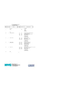
Census Tracts
1940 The census tract became an official geographic entity for which the Census Bureau would publish data for. Census tracts covered major cities and block number areas (BNAs) covered many other cities 1970 1980 The number of BNAs increased and the criteria of the BNA matched the census tract 1990 Census tracts and BNAs covered the entire nation
Download Census Tracts

Information
Domain:
Source:
Link to this page:
Documents from same domain
Michigan Department of Treasury 3965 (Rev. 4/05) …
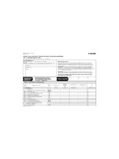
www2.census.govLocal Unit Identification FORM F-65(MI) (4-14-2005) Michigan Department of Treasury F-65(MI) 3965 (Rev. 4/05) ANNUAL LOCAL UNIT FISCAL REPORT FOR FISCAL YEARS ENDING BETWEEN
Maps - Census
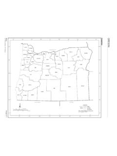
www2.census.govMaps Oregon E-3 U.S. Census Bureau, 2010 Census COUNTY MAP SEC Baker 3 Benton 1 Clackamas 1 Clatsop 1 Columbia 1 Coos 6 Crook 2 …
Maps - Census
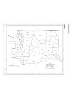
www2.census.govThe county subdivision name is shown only if different than the name of the place. Section Locator. Maps Washington E-3 U.S. Census Bureau, 2010 Census COUNTY MAP SEC Adams 5 Asotin 5 Benton 5 Chelan 3 Clallam 1 Clark 6 Columbia 5 Cowlitz 6 Douglas 3 Ferry 4 Franklin 5 Garfield 5 Grant 3 Grays Harbor 1 Island 2 Jefferson 1 …
Geographic Information Systems - census.gov
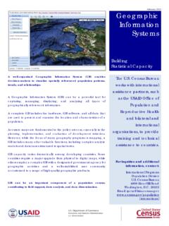
www2.census.govGeographic Information Systems . Building . Statistical Capacity . The U.S. Census Bureau works with international assistance partners, such as the USAID Office of
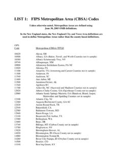
LIST 1: FIPS Metropolitan Area (CBSA) Codes
www2.census.govLIST 1: FIPS Metropolitan Area (CBSA) Codes ... the New England City and Town Area definitions are ... 11500 Anniston-Oxford, AL
Population by Region and Country: 1950-2050
www2.census.govRegion and country or area 1950 1960 1970 1980 1990 2002 2010 2025 2050 .Vietnam 25,348 31,656 42,577 53,661 66,637 80,577 89,223 104,436 116,813 LATIN AMERICA AND THE

Fun Facts: Father’s Day–June 17 - census.gov
www2.census.govFun Facts: Father’s Day ... Sources: Data on this page come from the U.S. Census Bureau’s 2014 Survey of Income and Program Participation, 2017 Current Population Survey, and 2016 County Business Patterns. Fathers by the Numbers 72 million* The estimated number of fathers across the nation.
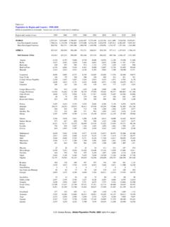
Fun Facts: 2017 Holiday Season - Census
www2.census.govCENSUS.GOV/SCHOOLS Fun Facts: The 2017 Holiday Season Holiday Celebrations This festive season, or simply the holidays, is a time for gathering and celebrating with family
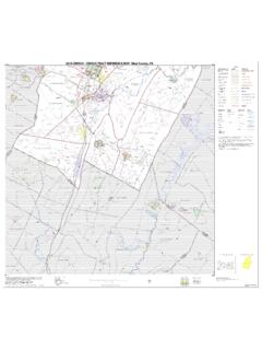
2010 Census - Census Tract Reference Map
www2.census.govCanoe Creek State Park Blue Knob State Park State Gamelands No 41 Warriors Path State Park State Gamelands No 41 F ra n k s t o w n Hollidaysburg° B r a
New York City Housing and Vacancy Survey 2017 Record ...
www2.census.govNew York City Housing and Vacancy Survey 2017 Record Layout Household Record -- Occupied Units 1 Record Type 1=OCCUPIED 2
Related documents

Congressional Nominations to U.S. Service Academies: An ...
fas.orgApr 13, 2017 · Congressional nominations ensured that academy appointees represented all geographic areas of the United States, came from a diverse set of family backgrounds, and would not be subject to executive branch political ... 4 Based on admissions data for the class of 2019 from USMA, USNA, USAFA, and USMMMA, available on the

Get help and support A-LEVEL GEOGRAPHY - AQA
filestore.aqa.org.ukContents 1 Introduction 5 1.1 Why choose AQA for A-level Geography 5 1.2 Support and resources to help you teach 5 2 Specification at a glance 7 2.1 Subject content 7

INTRODUCTION: BASIC GEOGRAPHIC CONCEPTS
ses.wsu.eduThe goal is to minimize the distortion based the ... A file used for storing the geometric location and attribute information of geographic features. Published Map File for ArcReader .pmf A read-only map file created using the ArcGIS Publisher extension. Read-only maps

7 Geographic patterns of crime - GOV.UK
assets.publishing.service.gov.ukGeographic patterns and concentrations of crime varied by crime type. • Sixty-two per cent of robberies in England and Wales were recorded by just three ... The BCS crime count is based on the home location of the victim irrespective of where in England and Wales the crime actually took place2. Police recorded crime, however,

Geographic and Vertical Transformations - ArcGIS
desktop.arcgis.comArcGIS Desktop 10.8.2 Geographic and Vertical Transformation Tables Note: Some numbers have been rounded for display. Area of use values are in degrees based upon WGS 1984. Transformation accuracies are approximate. Table of Contents

APPENDIX K: Emergency Preparedness and Response …
www.medicaid.govJul 25, 2000 · Specify the geographic areas affected by the emergency. For example, the state may use geographic areas such as counties, cities, state planning regions or human catchment areas, or political subdivisions such as counties or municipalities of the state. When the geographic area affected is limited to political subdivision, list the subdivisions.

1001 - National Geographic
www.nationalgeographic.combased, non-profit, non-religious, non-political organization. Founded in the united kingdom in 1999, FStc works with ... geographic Books Subsidiary rights: ngbookrights@ngs.org

Geographic Factors Influencing Japan - Roslyn High School
www.roslynschools.orgFeudalism in Japan A. Organization of Feudal Japan. 1. The mikado or emperor ruled in theory but in reality was powerless. 2. The shogun, or most influential lord, controlled military affairs as well as justice, lawmaking and finance; a military dictator 3. The daimyos, or local lords, held landed estates and maintained private armies. 4. The samurai, or warriors, served in the lord’s …
Tennessee Social Studies Standards - TN.gov
www.tn.govTeachers should center instruction on inquiry-based models, which require students to engage in critical thinking, self-assessment, reasoning, problem-solving, ... for dept and clarity. Final , students wm focus on current human and physical geographic issues important in he contemporary U.S. and global society. This course will place Tennessee ...

Digital Media: Rise of On-demand Content - Deloitte
www2.deloitte.comlike YouTube and Subscription-based digital content providers like Spotify have also acted as a catalyst in the growth of audio/video data streaming. The global audio and video traffic combined is expected to reach 82% of all internet traffic by 2018.3 6 89.3 71.8 58.0 46.7 37.3 29.3 2013