
Chapter 6 Survey Datums
Highway Surveying Manual Page 6-1 January 2005 Chapter 6 Survey Datums 6-01 General Today’s multiorganizational Project Development efforts require the use of common,
Download Chapter 6 Survey Datums

Information
Domain:
Source:
Link to this page:
Documents from same domain

Chapter 6 Seismic Design
www.wsdot.wa.govChapter 6 Seismic Design 6.1 Seismic Design Responsibility and Policy 6.1.1 Responsibility of the Geotechnical Designer The geotechnical designer is responsible for providing geotechnical/seismic input
Project Management Manual - wsdot.wa.gov
www.wsdot.wa.govCommunication Management Plan [Output/Input] The document that describes: the communications needs and expectations for the project; how and in what format information will be

Project Risk Management Guide
www.wsdot.wa.govProject Management Online Guide in the Risk Management Plan spreadsheet. Larger, more complex projects may wish to use more robust analysis techniques via Monte Carlo simulation models.
Chapter 6 Storm Drains - Washington State …
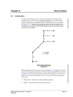
www.wsdot.wa.govWSDOT Hydraulics Manual M 23-03.03 Page 6-1 June 2010 Chapter 6 Storm Drains 6-1 Introduction A storm drain (storm sewer) is a network of pipes that conveys surface

Cost Estimating Manual for Projects
www.wsdot.wa.govWSDOT Cost Estimating Manual for Projects M 3034.03 Page i April 2015 Foreword WSDOT’s vision is to be the best at providing a sustainable and

Maintenance Manual - Washington State …
www.wsdot.wa.govForeword Reliable, well-maintained highway transportation facilities are essential to the well being of the state, its citizens, and its commerce.
Chapter 4 Soil and Rock Classification and Logging
www.wsdot.wa.govChapter 4 Soil and Rock Classification and Logging 4.1 Overview The detailed description and classification of soil and rock are an essential part of the

Chapter 1310 Intersections
www.wsdot.wa.govIntersections Chapter 1310 Page 1310-2 WSDOT Design Manual M 22-01.14 July 2017 1310.02 Design Considerations Consider all potential …
Chapter 25 Right of Way - Washington State …
www.wsdot.wa.govRight of Way Chapter 25 Page 25-2 WSDOT Local Agency Guidelines M 36-63.36 June 2018.11 WSDOT Services – At the earliest possible date, the local agency should notify

Chapter 1510 Pedestrian Facilities
www.wsdot.wa.govWSDOT Design Manual M 22-01.10 Page 1510-1 July 2013 Chapter 1510 Pedestrian Facilities 1510.01 General. 1510.02 References. 1510.03 Definitions
Related documents

Datums, Coordinate Systems, Coordinate Reference Systems ...
2007.foss4g.orgDatums, Coordinate Systems, Coordinate Reference Systems and Datum Transformations Dean C. Mikkelsen, B.Sc., P.Eng. Frank Warmerdam, OSGeo, FWTools

IMO information papers on ECDIS: IMO SN Circ 207 ...
shippingregs.orgIMO information papers on ECDIS: • IMO_SN_Circ_207_Difference between RCDS and ECDIS (07 Jan 1999) • IMO_SN_Circ_213_Datums (31 May 2000)

Brosjure 2018 - warries.co.za
warries.co.za2 inhoudsopgawe bladsy 1. die doel van die kompetisie ..... 3 2. belangrike datums .....
GIS&T Body of Knowledge - AAG
www.aag.orgGeographic Information Science and Technology Body of Knowledge First Edition Edited by David DiBiase, Michael DeMers, Ann Johnson, Karen Kemp,

ArcGIS Datums and Transformations Quick Reference
www.gdsihawaii.comArcGIS Datums and Transformations Quick Reference May 2013 What is a Datum? Simply put, a datum is a model used for calculating the location of the Earth's center.

香 港 大 地 測 量 基 準 說 明 - geodetic.gov.hk
www.geodetic.gov.hk香 港 大 地 測 量 基 準 說 明 Explanatory Notes on Geodetic Datums in Hong Kong Survey & Mapping Office Lands Department 地政總署 測繪處

What is a datum? - National Tidal and Sea Level Facility
www.ntslf.orgInformation Sheet www.noc.ac.uk e-mail: dataproducts@noc.ac.uk Page 1 of 1 Tidal Datums What is a datum? When measuring the height of a water level, that height must be specified relative to …
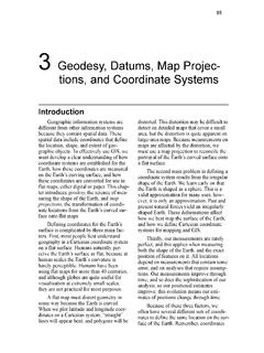
3 Geodesy, Datums, Map Projec- tions, and Coordinate …
www.paulbolstad.net85 3 Geodesy, Datums, Map Projec- tions, and Coordinate Systems Introduction Geographic information systems are different from other information systems because they contain spatial data.