Transcription of 11: C1 STREAMS AND BUFFER REQUIREMENTS
1 Natural Resource Inventory (NRI) Franklin Township, Warren County, New Jersey Prepared by Princeton Hydro, LLC 16 June 2007 11: C1 STREAMS AND BUFFER REQUIREMENTS In the beginning of 2004, new Stormwater Quality rules were adopted, as mandated by the United States Environmental Protection Agency. NJDEP took additional steps to identify and protect high quality water resources. These special water resource protection areas are established along all waters designated Category One (C1), and perennial or intermittent STREAMS that drain into or upstream of C1 waters.
2 These areas are established for the protection of water quality, aesthetic value, exceptional ecological significance, exceptional recreational significance, exceptional water supply significance, and exceptional fisheries. The most notable regulation is the implementation of a 300 foot BUFFER zone on each bank of a C1 stream. Other rules deal with designated areas for future development, the creation of a stream corridor protection plan, and cleaner stormwater discharge into the special water protection area, or the C1 stream itself. For the official rules regarding the special water resources protection areas, please reference the New Jersey Register ( 7 (h)), ( ).
3 In addition, all STREAMS located within the Highlands Preservation Area, are afforded 300 foot buffers per the Highlands Water Protection and Planning Act. Route 57/ Morris Turnpike bisects the Township and delineates the boundary between the Highlands Planning and Preservation Areas. Therefore, all stream segments north of Route 57 within the Township are protected by 300 foot buffers because they lie within the Highlands Preservation Area. Portions of the Musconetcong River also serve as a Highlands Preservation/Planning Area border in the southern section of the Township.
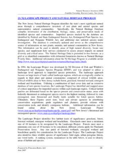
4 Thus, the sections of the Musconetcong River that delineate this line, the western and eastern stretches within the Township, are protected by 300 foot buffers. The tributaries that flow through the central portion of the Township that are not classified as C1 waters and that lie within the Highlands Planning Area are not protected by 300 foot buffers. For more information on the Highlands Act, please refer to Section 16 and and Approximately stream miles are protected by the C1/300 stream BUFFER requirement within Franklin Township. (Figure 10). The C1 STREAMS include: Halfway House Brook, Montana Brook, Mill Brook, one tributary to the Musconetcong River, and Pohatcong Creek and all its tributaries.
5 All stream segments that are included in the Highlands Preservation Area are afforded 300 foot buffers and include: Halfway House Brook, Montana Brook, Mill Brook and the eastern and western stretches of the Musconetcong COUNTYWARREN COUNTYM orris CanalPohatcong CreekPohatcong CreekMill BrookMontana BrookMusconetcong RiverBloomsbury BoroBethlehem TownshipGreenwich TownshipWashington TownshipHarmony TownshipMAPLE AVEBICKEL RDBUTLER RDKITCHEN RDANDERSON RDSHIRTS RDGOOD SPRINGS RDMORRIS TPKE (RT. 57)WHITES RDHARLEY CTBRYAN RDEDISON RDDIRT LNHERLEMAN RDHOFFMAN RDBEIDLEMAN RDMICA MINE RDINSCHO RDBUTTERMILK BRIDGE RDMONTANA RDSTEWARTSVILLE RDWOOLVERTON RDSURRY LNCLIFF SIDE DRMORGAN RDLENAPE TRLHALLS MILL RDYOLMAN RDOBERLY CTSCHOOL STCEMETERY HILL RDHALFWAY HOUSE RDSTEEPLE CHASEWARNE WAYVAN SYCKLE RDRIDDLE CTLIMEKILN RDSECOND STSINGLEY LNWILLOW GROVE RDMART AVEDICKENS LNMAIN STMILLBROOK RDBLOOMSBURY RDMOUNTAIN VIEW RDTHIRD STASBURY-BROADWAY RDWARNE WAYASBURY-BROADWAY RDBLOOMSBURY RDBLOOMSBURY RDASBURY-BROADWAY RDBLOOMSBURY RDMORRIS TPKE (RT.)
6 57)MILLBROOK RDMORRIS TPKE (RT. 57)ANDERSON RDANDERSON RDGOOD SPRINGS RDMORRIS TPKE (RT. 57)STEWARTSVILLE RDMORRIS TPKE (RT. 57)EDISON RDBUTTERMILK BRIDGE RDMAIN STBRYAN RDMONTANA RDMOUNTAIN VIEW RDWhite TownshipLopatcong TownshipFile: P:\0420\Projects\0420006\GIS\MXD\ JERSEY COUNTY MAPFIGURE 10 CATEGORY ONE WATERSWITH ASSOCIATED BUFFERSDELAWARE RIVEROCEANMORRISSUSSEXBURLINGTONWARRENMO NMOUTHHUNTERDONBERGENMIDDLESEXMERCERPASS AICESSEXUNIONSOMERSETCAMDENGLOUCESTERHUD SONSALEMU03,0001,500 Feet1 inch equals 3,000 feetSOURCES:1. Parcel, roads and the Franklin Township Boundary data obtained from Warren County Planning Dept. "this map was developed using the Warren County New Jersey, Geographic Information System digital data, but this secondary product has not been verified by Warren County and is not county- authorized"2.
7 STREAMS data is a combination of both the USGS "Blue Line" Stream data (obtained from the NJ DEP, Division of GIS) and USDA, NRCS Soil Book Survey Stream data. Hardcopy Soil Survey Book pages were scanned and the images registered and rectified, and stream data were heads-up digitizedNATURAL RESOURCE INVENTORYFRANKLIN TOWNSHIPWARREN COUNTY, NEW JERSEYL egendCounty BoundaryMunicipal BoundariesParcelsRoadsPonds/LakesPRINCET ON HYDRO, OLD YORK ROAD, SUITE 1 RINGOES, NEW JERSEY, 08551 StreamsC1C2 Stream Buffers150300 Category One (C1) waters are designated for purposesof implementing the antidegradation policies set forth atNew Jersey Administrative Code ( ) 7 (d)
8 ,for protection from measurable changes in water qualitycharacteristics because of their clarity, color, scenic setting,other characteristics of aesthetic value, exceptionalecological significance, exceptional recreational value,exceptional water supply significance, or exceptionalfisheries resource(s).All STREAMS listed as Category Two (C2) on this map thathave associated stream buffers are receiving C1 protectiondue to the fact that they lie within the Highlands Preservation Musconetcong River was designated as aFederal Wild and Scenic River in December of 2006