Transcription of Cape Cod Bay
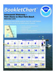
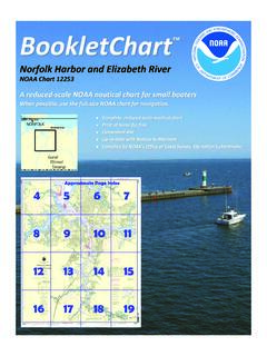
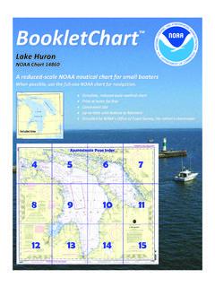
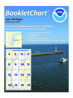
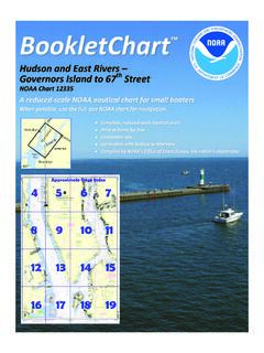
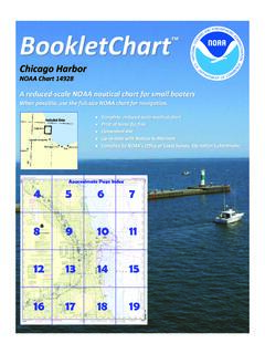
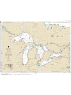
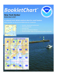
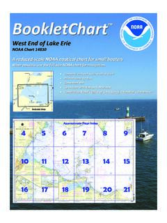
1 BookletChart . cape Cod Bay NOAA Chart 13246. A reduced-scale NOAA nautical chart for small boaters When possible, use the full-size NOAA chart for navigation. Published by the The shallow harbors of cape Cod Bay, such as Plymouth, Barnstable, and Wellfleet, usually are closed to navigation by ice a part of each winter. National Oceanic and Atmospheric Administration This ice, together with the ice that forms in the shallower parts of cape National Ocean Service Cod Bay in severe winters, is driven by the winds out into the bay. There Office of Coast Survey it masses into heavy fields or windrows, sometimes as much as 10 feet or more thick, making navigation in parts of the bay unsafe or impractical.
2 888-990-NOAA Deep-draft vessels entering cape Cod Bay from the northward should pass eastward of the lighted whistle buoy which is about 7 miles What are Nautical Charts? northeastward of Brant Rock and well east of the extremity of the broken bottom extending over 4 miles offshore in this direction. Nautical charts are a fundamental tool of marine navigation. They show Between Rocky Point and Manomet Point, there are several outlying water depths, obstructions, buoys, other aids to navigation, and much rocks which will be avoided by giving the shore a berth of 1 mile. The more. The information is shown in a way that promotes safe and shore is backed by high wooded hills, the most conspicuous of which is efficient navigation.
3 Chart carriage is mandatory on the commercial Manomet Hill, 390 feet high. Manomet Point is a bluff about miles ships that carry America's commerce. They are also used on every Navy southeast of Rocky Point. Also prominent is the large rectangular reactor and Coast Guard ship, fishing and passenger vessels, and are widely housing of the Pilgrim Nuclear Power Station, about mile carried by recreational boaters. southeastward of Rocky Point. This basin is hazardous to approach in What is a BookletChart ? heavy weather since seas break over the breakwaters. cape Cod Bay south of Wellfleet Harbor, Mass.; naval aircraft This BookletChart is made to help recreational boaters locate bombing target area.
4 (a) The danger zone. A circular area with a radius themselves on the water. It has been reduced in scale for convenience, of 1,000 yards having its center on the aircraft bombing target hulk but otherwise contains all the information of the full-scale nautical James Longstreet in cape Cod Bay at 41 49'46"N., 70 02'54"W. chart. The bar scales have also been reduced, and are accurate when Barnstable Harbor, Dangers. The south side of the harbor is very foul used to measure distances in this BookletChart. See the Note at the with covered rocks and ledges, most of which are unmarked; extreme bottom of page 5 for the reduction in scale applied to this chart.
5 Caution should be exercised if heading for the yacht club without local Whenever possible, use the official, full scale NOAA nautical chart for knowledge. Several rocks near the channel leading to the yacht club are navigation. Nautical chart sales agents are listed on the Internet at marked by private seasonal buoys; these aids should not be taken as marking the entrance to Maraspin Creek. This BookletChart does NOT fulfill chart carriage requirements for Wellfleet Harbor, Dangers. Extensive shoals are in the entrance. regulated commercial vessels under Titles 33 and 44 of the Code of Billingsgate Shoal extends miles westward of Billingsgate Island, on Federal Regulations.
6 The western side of the entrance to the harbor. The island is covered at high water. A lighted bell buoy marks the southwest end of the shoal. Notice to Mariners Correction Status Numerous sunken wrecks are south and west of the shoal; mariners are advised to exercise caution. This BookletChart has been updated for chart corrections published in The approach channel into Wellfleet outer harbor leads between the the Coast Guard Local Notice to Mariners, the National Geospatial shoals and is narrow in places, but it is marked by unlighted and Intelligence Agency Weekly Notice to Mariners, and, where applicable, seasonal lighted buoys and is easily followed in daytime in clear the Canadian Coast Guard Notice to Mariners.
7 Additional chart weather. The breakwater that protects the inner harbor is reported to corrections have been made by NOAA in advance of their publication in cover at extreme high tides. Bush stakes mark the clam and oyster flats a Notice to Mariners. The last Notices to Mariners applied to this chart in the inner harbor. are listed in the Note at the bottom of page 7. Coast Pilot excerpts are Provincetown Harbor, Dangers. Shank Painter Bar, which extends to a not being corrected. maximum distance of mile offshore between Race Point and Wood For latest Coast Pilot excerpt visit the Office of Coast Survey website at End Lights, rises abruptly from deep water.
8 Wood End Bar is the continuation of the shoal that makes sharply into Wood End. A lighted 46 bell buoy is about mile southwestward of Wood End Light. A 2,500- foot stone breakwater is about 300 yards southeastward of the end of (Selected Excerpts from Coast Pilot) the town pier at Provincetown. The breakwater extends northeastward cape Cod Bay is contained between the from a point in 42 02'45 N., 70 10'55 W., approximately parallel to the peninsula of cape Cod, on the east and shoreline. The east and west ends of the breakwater are each marked by south, and the mainland of Massachusetts a light. Strangers should exercise caution when operating in the area.
9 On the west. Between these limits the bay is Caution. Shipping should keep a sharp lookout when navigating in the about 20 miles in diameter with depths vicinity of Race Point, especially during periods of darkness and low ranging from 10 to 32 fathoms, except close visibility, because of the numerous fishing craft which operate in the to the shore and in its southeasterly part. area. There are large fish weirs in the harbor. Race Point, the northwesterly extremity of cape Cod, is the eastern point; and Gurnet Point, on the north side of the entrance to Plymouth Bay, is the western point of the entrance to cape Cod Bay. Coast Guard Rescue Coordination Center Within the limits of cape Cod Bay are several harbors, including those of 24 hour Regional Contact for Emergencies Plymouth on the western shore, Sandwich and Barnstable on the southern shore, and Wellfleet and Provincetown on the eastern shore.
10 It RCC Boston Commander 2. is also the approach to cape Cod Canal, which connects cape Cod Bay 1st CG District (617) 223-8555. with Buzzards Bay. Boston, MA. Navigation Managers Area of Responsibility Northeast Great Lakes Region Lt. Meghan McGovern Tom Loeper Northwest and Pacific Islands Crescent Moegling Chesapeake and Delaware Bay Steve Soherr California Jeff Ferguson Mid-Atlantic Lt. Ryan Wartick Western Gulf Coast Southeast Alan Bunn Central Gulf Coast Kyle Ward Alaska Tim Osborn South Florida Lt. Timothy M. Smith Puerto Rico Virgin Islands Michael Henderson NOAA's navigation managers serve as ambassadors to the maritime community.