Transcription of Norfolk Harbor and Elizabeth River
1 BookletChart Norfolk Harbor and Elizabeth River NOAA Chart 12253 A reduced-scale NOAA nautical chart for small boaters When possible, use the full-size NOAA chart for navigation. 2 Published by the National Oceanic and Atmospheric Administration National Ocean Service Office of Coast Survey 888-990-NOAA What are Nautical Charts? Nautical charts are a fundamental tool of marine navigation. They show water depths, obstructions, buoys, other aids to navigation, and much more. The information is shown in a way that promotes safe and efficient navigation. Chart carriage is mandatory on the commercial ships that carry America s commerce. They are also used on every Navy and Coast Guard ship, fishing and passenger vessels, and are widely carried by recreational boaters.
2 What is a BookletChart ? This BookletChart is made to help recreational boaters locate themselves on the water. It has been reduced in scale for convenience, but otherwise contains all the information of the full-scale nautical chart. The bar scales have also been reduced, and are accurate when used to measure distances in this BookletChart. See the Note at the bottom of page 5 for the reduction in scale applied to this chart. Whenever possible, use the official, full scale NOAA nautical chart for navigation. Nautical chart sales agents are listed on the Internet at This BookletChart does NOT fulfill chart carriage requirements for regulated commercial vessels under Titles 33 and 44 of the Code of Federal Regulations.
3 Notice to Mariners Correction Status This BookletChart has been updated for chart corrections published in the Coast Guard Local Notice to Mariners, the National Geospatial Intelligence Agency Weekly Notice to Mariners, and, where applicable, the Canadian Coast Guard Notice to Mariners. Additional chart corrections have been made by NOAA in advance of their publication in a Notice to Mariners. The last Notices to Mariners applied to this chart are listed in the Note at the bottom of page 7. Coast Pilot excerpts are not being corrected. For latest Coast Pilot excerpt visit the Office of Coast Survey website at (Selected Excerpts from Coast Pilot) Craney Island. The offshore wharf and piers are used only by Government vessels.
4 Two daybeacons off the northeast end of Craney Island mark submerged rocks. A submerged water main crosses from Craney Island to the north side of Lamberts Point; vessels are not to anchor in the vicinity of the lighted range that marks the crossing. Portsmouth Coast Guard Station is on the west side of Craney Island Creek. Western Branch. A marked channel leads from the main channel in Elizabeth River for miles upstream. In January 1998, the controlling depth was 17 feet (18 feet at midchannel) in the dredged channel to the first bridge, thence 16 feet (18 feet at midchannel) to the head of the project about mile above the first bridge; then about 7 feet could be carried to Drum Point, mile above the third bridge.
5 A 540-foot lighted pier 1 mile above the entrance to Western Branch extends to the northern edge of the marked channel. West Norfolk has a shipyard and small-craft facilities. Supplies, fuel, and slips are available. A 280-foot fishing pier extends from the southeast shore about miles above the Churchland bridges. Scott Creek is entered through a channel, marked by daybeacons, which had a controlling depth of 8 feet. The channel leads to old fishing wharves now used by pleasure craft. A marina is on the point on the south side of the creek, about mile above the channel entrance, and had a depth of 4 feet in the approach and alongside the piers. Berthage, electricity, water, ice, towing, and launching ramp.
6 Hospital Point is the site of a Naval Hospital. The main hospital building is visible for many miles. Norfolk . The midpoint of the downtown section can be taken as the City Wharf at the foot of West Main Street. City Wharf has depths of 15 feet at the face, but is in poor condition. The wharves northwest and southwest of West Main Street have depths of 14 to 20 feet alongside. Smith Creek has entrance depths of about 3 feet with deeper water inside, but the entrance is restricted by a highway bridge with a clearance of 13 feet. Small-craft anchorages are in Smith Creek. Waterside is in the downtown area of Point. A municipal marina has depths of about 16 feet at the entrance, inside the marina, and alongside the berths.
7 Transient berths are available year-round. A sewage pump-out station is at the marina. Electricity is at the berths; ice and provisions are available nearby. The marina staff monitors VHF-FM channels 16 and 68. Above the Norfolk Southern Railway Bridge, the natural channel has depths of 10 to 18 feet to the forks miles from the entrance, and usually is marked by bush stakes. Downtown Norfolk is on the north side of Eastern Branch, and is on the south side. Traffic is fairly heavy as far as Campostella Bridge. Depths at most of the piers on both sides of the branch range from 14 to 25 feet. Southern Branch is a part of the Intracoastal Waterway route southward to Albemarle Sound. A speed limit of 6 knots is prescribed for that part of Southern Branch between Eastern Branch and the first bridge.
8 A safety zone is in effect in the Elizabeth River when a naval aircraft carrier transits the River to or from the Norfolk Naval Shipyard. (See , chapter 2, for limits and regulations.) Craney Island, now a part of the mainland, is on the west side of Elizabeth River miles south of Sewells Point. The low and thinly wooded area is the site of a navy fuel depot, and the offshore wharf and piers, all on the eastern side, are used only by Government vessels. Two daybeacons close off the northeast end of Craney Island mark submerged rocks. The offshore wharf and piers have depths of 22 to 47 feet alongside. A submerged water main crosses from Craney Island to the north side of Lamberts Point; vessels are cautioned not to anchor in the vicinity of the lighted range that marks the crossing.
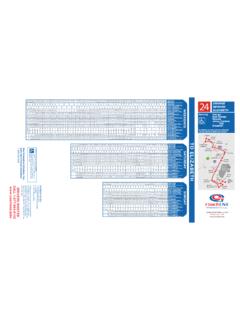
9 Portsmouth Coast Guard Station is on the west side of the entrance to Craney Island Creek. Coast Guard Rescue Coordination Center 24 hour Regional Contact for Emergencies RCC Norfolk Commander 5th CG District (575) 398-6231 Norfolk , VA G Lateral System As Seen Entering From Seaward on navigable waters except Western Rivers PORT SIDE ODD NUMBERED AIDS GREEN LIGHT ONLY FLASHING (2) PREFERRED CHANNEL NO NUMBERS MAY BE LETTERED PREFERRED CHANNEL TO STARBOARD TOPMOST BAND GREEN PREFERRED CHANNEL NO NUMBERS MAY BE LETTERED PREFERRED CHANNEL TO PORT TOPMOST BAND RED STARBOARD SIDE EVEN NUMBERED AIDS RED LIGHT ONLY FLASHING (2)
10 FLASHING FLASHING OCCULTING GREEN LIGHT ONLY RED LIGHT ONLY OCCULTING QUICK FLASHING QUICK FLASHING ISO COMPOSITE GROUP FLASHING (2+1) COMPOSITE GROUP FLASHING (2+1) ISO "1" Fl G 6s G "9" Fl G 4s GR "A" Fl (2+1) G 6s RG "B" Fl (2+1) R 6s "2" Fl R 6s 8 R "8" Fl R 4s LIGHT G C "1" LIGHTED BUOY G "5" GR "U" GR C "S" RG N "C" RG "G" LIGHT 6 R N "6" LIGHTED BUOY R "2" CAN DAYBEACON CAN NUN NUN DAYBEACON For more information on aids to navigation, including those on Western Rivers, please consult the latest USCG Light List for your area. These volumes are available online at 2 2 C U 5 1 VHF Marine Radio channels for use on the waterways:Channel 6 Inter-ship safety 9 Communications between boats and 13 Navigation purposes at bridges, locks, and 16 Emergency, distress and safety calls to Coast Guard and others, and to initiate calls to other vessels.