Example: barber
Cape York Peninsula - Parks and forests | Department of ...
Sitting by a camp fire and sleeping under the stars is an essential ingredient of your Cape York Peninsula adventure! Consider your camping options before you start planning your trip. • For other camping areas, during school holiday periods book at least 2–3 months in advance. • Outside of holiday periods, book at
Tags:
Information
Domain:
Source:
Link to this page:
Documents from same domain

Teewah Beach camping zones map Cooloola Recreation Area
parks.des.qld.gov.auBring your own portable toilet. Portable toilets are mandatory for all campers in the Teewah Beach camping zones. All Qld road rules apply on Teewah Beach. Legend Recreation Area Water 4WD camping zone No camping area 4WD camping only 4WD camper trailer 4WD caravan Toilets Bring your own portable toilet Portable toilet waste disposal Shower ...
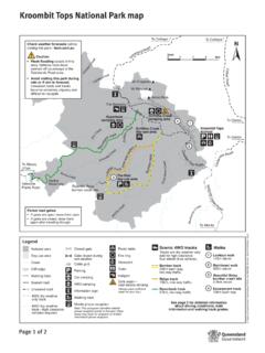
Kroombit Tops National Park map - Parks and forests
parks.des.qld.gov.auTitle: Kroombit Tops National Park map Author: Queensland Government; Queensland Parks and Wildlife Service Subject: Map of Kroombit Tops National Park indicating access, facilities, features, tracks and camping.

Cooloola Conditions Report
parks.des.qld.gov.auwater for the first time. Never drive or park on the dunes and only use established access tracks to camp sites. Do not interfere with turtle nests, eggs or hatchlings. Stay well clear of turtles leaving the water or crossing the beach, and avoid driving on the beach and using bright lights between 6pm and 6am during breeding season.

Moreton Island National Park and Recreation Area map
parks.des.qld.gov.auTitle: Moreton Island National Park and Recreation Area map Author: Queensland Department of Environment and Science Subject: Moreton Island National Park and Recreation Area map, indicating access, facilities, features, tracks and vehicle access and speed zones.
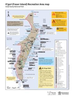
K’gari (Fraser Island) Recreation Area map
parks.des.qld.gov.auTitle: K'gari (Fraser Island) Recreation Area map Great Sandy National Park Author: Queensland Department of Environment and Science Subject: Map of K'gari (Fraser Island), Great Sandy National Park indicating locality, access, walking tracks and facilities.

Noosa National Park walking tracks map Headland Section
parks.des.qld.gov.auGranite Bay Alexandria Bay Lion Rock Noosa Heads Surf Life Saving Club Sunshine Beach Surf Life Saving Club Boiling Day-use area Pot Dolphin Point Hell’s Gates Laguna Lookout Sunshine Beach e Sunshine D a v i d L o w W a y Surf St Emergency radio Sunshine Beach edge Rd ong e Bicentennial Dr 3 1 2 4 4 5 4 2 Park Rd St Seaview Tce

K'gari (Fraser Island) conditions report
parks.des.qld.gov.auK’gari (Fraser Island) conditions report Everything is protected – plants, animals, natural and cultural features www.des.qld.gov.au General alerts Reviewed 06 January 2022 The Department of Environment and Science (DES) continues to monitor and receive guidance from the Government in relation to COVID-19 health and safety
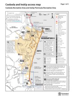
Cooloola and Inskip access map - Parks and forests
parks.des.qld.gov.au(Northern beach access road) See northern access map page 2 Bullock Inskip Point Inskip Peninsula ... including in vehicles or trailers traversing beaches and inland tracks. High clearance 4WD vehicles with ... Horses are permitted on the council horse trail and on the beach indicated on the map. (no public facilities) Noosa River estuary

Moreton Bay Marine Park
parks.des.qld.gov.auEntry and use guide Gene r a l se zone Ha b i t a t protection zone C o n se r v ation park zone M arine n atio nal park zone Boating Yes Line fishing Yes Yes Yesa Nob Crabbing Yes Yes Yesc Nob Trolling Yes Yes Yes No Bait gathering Yes Yes Yes Nob ait netting Yes No Netting (other than bait netting) Yes Yes Nob Nob Limited spearfishing Yes ...
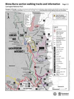
Lamington Binna Burra Map - Parks and forests
parks.des.qld.gov.auLamington National Park map: Binna Burra walking tracks and information Author: Queensland Department of Environment and Science Subject: Map of the Binna Burra section of Lamington National Park showing access, facilities and recreational opportunities and safety messages. Legend provided. Keywords
Related documents
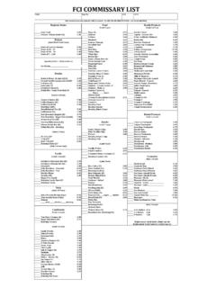
FCI COMMISSARY LIST - Federal Bureau of Prisons
www.bop.govJolly Ranchers - Fire 2.10 Rotating Cookies Eyebrow Pencil Brown 2.65 Starlite Mints 0.85 Raw Almonds (K) 3.00 Eye Liner–Liquid Black 6.05 Licorice (K) 1.30 Deluxe Mixed Nuts 3.15 Eye Liner–Liquid Brown 6.05

UN SUPPLIER CODE OF CONDUCT
www.un.orgUN Supplier Code of Conduct Rev.06 – December 2017 2 3. Management, Monitoring and Evaluation: It is the expectation of the UN that its suppliers, at …

global editorial
cdn.theconversation.comRepublication 19 Regional Editorial Policies 20 Contents. 3 The Conversation is the world's leading publisher of esearr ch-based news and analysis. It is a unique collaboration between academics and journalists. Introduction & Guiding Principles The purpose of these policies, ...
Thanks to Kathleen Joaquin of SAISD for making her lesson ...
rickriordan.commentions what happened at the beginning, middle and end of the chapter, yet no great detail is given. Once the students are finished, have them place their Post-It inside the circle (with their name on the back of the Post-It). When all the Post-Its are in the circle, as a class, discuss what events should be mentioned in order to be a good ...