Transcription of Chapter 11 Census Blocks and Block Groups
1 Census Blocks , the smallest geographic area for which the Bureau of the Census collects and tabulates decennial Census data, are formed by streets, roads, railroads, streams and other bodies of water, other visible physical and cultural features, and the legal boundaries shown on Census Bureau maps. Census data for these areas serve as a valu-able source for small-area geographic studies. The Census Bureau hasresponded to public demand for more geographic coverage of Census Block data by expanding the Census Block Statistics Program each dec- ade since Block data first were published in 1940. For the 1990 decen-nial Census , the Census Bureau tabulated data by Census Block for the entire Nation, as well as Puerto Rico and the Outlying Areas (Ameri-can Samoa, Guam, the Northern Mariana Islands, Palau, and the Virgin Islands of the United States). In 1990, the Census Bureau tabulated data for 7,020,924 Census Blocks .
2 Block Groups (BGs) are the next level above Census Blocks in the geo-graphic hierarchy (see Figure 2-1 in Chapter 2). A BG is a combination of Census Blocks that is a subdivision of a Census tract or Block number-ing area (BNA). (A county or its statistically equivalent entity contains either Census tracts or BNAs; it can not contain both.) A BG consists of all Census Blocks whose numbers begin with the same digit in a given Census tract or BNA; for example, BG 3 includes all Census Blocks num-bered in the 300s. The BG is the smallest geographic entity for which the decennial Census tabulates and publishes sample data. It has now largely replaced the earlier enumeration district (ED) as a small-areageographic unit for purposes of data presentation. For the 1990 decennial Census , local Census statistical areas committees were given the opportunity to delineate BGs in counties with Census tracts.
3 State officials were invited to delineate BGs in the remaining coun-ties. The Census Bureau delineated BGs for counties in which local and State officials chose not to participate in the BG program. The total num-ber of BGs delineated for the 1990 decennial Census was 229,466. Census Blocks and Block Groups 11-1 Census Blocks and Block GroupsChapter 1111-2 Census Blocks and Block GroupsHistory of Small Areas in CensusesThroughout most of the 1800s, the smallest data unit for which the CensusBureau collected information was the area assigned to an individual enu-merator, and the smallest area for which it reported data corresponded togeographic entities such as wards, communities, and townships. Historiesof the early censuses contain very little precise information abouthow these entities were subdivided for enumeration. Many of the assign-ments were verbal descriptions based on legally defined entities, commu-nity names, and major physical features.
4 Some enumerators developedtheir own geographic solutions by drafting sketch maps and by writingdescriptions of their enumeration area of Enumeration Districts From 1870 Through 1980 Over time, the instructions for enumerators became more specific; theyrevealed an increasing concern for the boundaries, size, and identificationof geographic subdivisions. For the 1870 Census , the Census Office (pred-ecessor of the Census Bureau) lowered the maximum size of the subdis-tricts used for enumeration from 50,000 to 6,000 people. For the 1880census, this number was reduced to 4,000, resulting in approximately28,000 districts of enumeration (later called enumeration districts, or EDs).This Census also was the first in which the Census Office provided mapsof EDs for use in taking the 1910, the Census Bureau began to delineate EDs to follow the bound-aries of legally or administratively defined entities such as villages, cities,wards, and minor civil divisions (MCDs).
5 This approach permitted theconvenient aggregation of EDs into larger geographic entities for tabula-tion and publication. It also underlined the need for maps to show theboundaries of counties, incorporated places, and MCDs in their correctlocation. The Census Bureau began to improve the ED maps, and for the1930 Census , included ED boundaries and numbers on all maps used inthe field ED, with minor revisions and improvements, continued to be thesmallest geographic unit for which Census data were available until censusCensus Blocks and Block Groups 11-3blocks were introduced for larger places in the 1940 Census ; even then,because Blocks were numbered only in limited areas, EDs continued tobe used as a collection and reporting unit in decennial censuses throughthe 1980 Blocks as Collection, Tabulation, and Publication UnitsLike the ED, the Census Block originally served the operational needs ofthe Census Bureau.
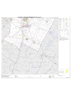
6 As early as the 1920 Census , the Census Bureau wasinstructing its enumerators in cities and built-up areas to do their workblock by Block : .. canvass one Block or square at a time .. Do not go back and forth acrossthe street .. Be sure you have gone around and through the entire Block beforeyou leave it. The Census Bureau found that following a Block -by- Block sequence wasan efficient way to compile data summaries at the ED level, and it graduallyextended this enumeration method to rural areas as well as urban. Canvass-ing individual Blocks in a geographic sequence remains the Census Bureau sstandard method of listing and verifying addresses or conducting a tradi-tional door-to-door enumeration (see Figure 11-1).Demographers, statisticians, and other data users had wanted to obtaincensus data by Block long before the Census Bureau was able to undertakesuch detailed geographic subdivision. For instance, in 1909, the TenementHouse Department of New York city had wanted the Census Bureau toidentify more than 49,000 city Blocks as part of the data dissemination forthe 1910 Census .
7 Expression of such needs undoubtedly influenced theCensus Bureau s eventual decision to compile and present information atthe Block Census Bureau first published Census Block data in 1940 as part of thenewly created Census of Housing. These Block statistics provided a detailedinventory of housing conditions within major cities during an era of Federalfinancial support for public works projects. City governments neededdetailed housing information for purposes such as efficiently upgrading the11-4 Census Blocks and Block GroupsFigure 11-1. Field Enumeration of a Census Block Prior to 1990 ElkRdBlake AveWhittier St51420120251020420341040951151351251551 6 OhmStED 5ED 3 For censuses earlier than 1990, an enumerator was asked to systematically coverthat portion of Block 202 within ED 5. This did not include the entire area ofBlock 202 because a portion, including a housing unit, was within ED 3.
8 The latterrequirement often confused enumerators and caused the Census Bureau, insome cases, to miss housing problem was corrected in the 1990 Census when the Census Bureau decidedto have enumerators canvass the physical entirety of each Block . Proceeding in aclockwise direction, the enumerator identified the location of all housing units tohis/her right, and located and indexed these on the enumerator map. The enumer-ator recorded the street or postal address for each housing unit in the addressregister within the correct Block number. All roads had to be canvassed so thathidden housing units were not Blocks and Block Groups 11-5level of urban services, modifying building codes, establishing and imple-menting zoning ordinances, and preparing plans for capital the 1940 and 1950 censuses, for cities that had Census Blocks , each individ-ual Block was identified on the ED map, and enumerators were instructed towrite the Block number on the Census questionnaire as they canvassed eachhousing unit.
9 Census Blocks were numbered beginning with one in eachcensus tract, city ward, or Block area that carried a one-letter identifier. (Theblock area was a summary unit used in place of Census tracts in Block num-bered cities that did not have Census tracts; it could not extend beyond thecity limits.)Data published for Census Blocks in 1940 were limited to selected housingstatistics collected for 191 cities that had a population of 50,000 or more atthe time of the 1930 Census . The same criterion applied in 1950 (using the1940 Census counts), after which the Census Bureau published Census blockdata for 209 places. There were separate published reports for each, includ-ing a map to accompany the data. In the 1960 Census , the Census Bureaupublished the total population for each Block , and reported Block statisticsfor 295 cities with a 1950 population of 50,000 or more. The Census Bureaualso expanded the program to include an additional 172 places, in whichdata users paid the Census Bureau to collect and publish Census Block total, the Census Bureau published data for over 736,000 Census blocksin the 1960 Blocks and Block Groups for the 1970 CensusCensus Block coverage and the mail Census In 1970, for the first time, alarge portion of the population was enumerated by mail rather than bythe conventional door-to-door enumeration.
10 As part of the mail Census , theCensus Bureau introduced many improvements in the base maps it used forthe Nation s major urban centers (the Metropolitan Map Series), and in itsmethodologies for the collection, tabulation, and dissemination of small-areadata. These changes had a direct positive effect on the delineation of censusblocks and BGs, allowing the Census Bureau to expand Census Block cover-age to include the expected extent of all 1970 urbanized Census Blocks and Block GroupsFirst use of Block Groups In the Block numbered areas, the Census Bureaudevised the Block group (BG) as a data tabulation and publication unitequivalent to the ED in non- Block numbered areas. Originally referred toas quarter tracts, BGs were subdivisions of a Census tract or Block num-bering area (BNA).Each BG consisted of a cluster of contiguous Census Blocks identified bythe same first digit of their three-digit Block number.