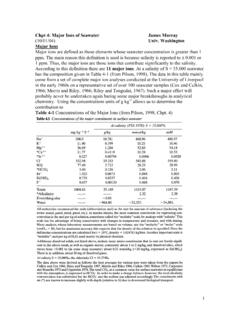
Transcription of Chapter-3 (Version 4) 07-01-06 - NCERT
1 You have observed water flowing throughthe rivers, nalas and even channelsduring rainy season which drain theexcess water. Had these channels not beenthere, large-scale flooding would haveoccurred. Wherever channels are ill-defined orchoked, flooding is a common flow of water through well-definedchannels is known as drainage and thenetwork of such channels is called a drainage system . The drainage patternof an area is the outcome of the geologicaltime period, nature and structure ofrocks, topography, slope, amount ofwater flowing and the periodicity ofthe you have a river near your village or city?
2 Have you ever been there for boating or bathing?Is it perennial (always with water) or ephemeral(water during rainy season, and dry, otherwise)?Do you know that rivers flow in the samedirection? You have studied about slopes in theother two textbooks of geography ( NCERT ,2006) in this class . Can you, then, explain thereason for water flowing from one direction tothe other? Why do the rivers originating from theHimalayas in the northern India and the WesternGhat in the southern India flow towards the eastand discharge their waters in the Bay of Bengal?A river drains the water collected from aspecific area, which is called its catchment area.
3 An area drained by a river and its tributariesis called a drainage basin . The boundary lineDRAINAGE SYSTEMCHAPTERF igure : A river in the Mountainous RegionImportant Drainage Patterns(i)The drainage pattern resembling the branches of a tree is known as dendritic the examplesof which are the rivers of northern plain.(ii)When the rivers originate from a hill and flow in all directions, the drainage pattern is knownas radial . The rivers originating from the Amarkantak range present a good example of it.(iii)When the primary tributaries of rivers flow parallel to each other and secondary tributariesjoin them at right angles, the pattern is known as trellis.
4 (iv)When the rivers discharge their waters from all directions in a lake or depression, thepattern is know as centripetal .Find out some of the patterns in the topo sheet given in Chapter 5 of Practical Work inGeography Part I ( NCERT , 2006).2021-2222 INDIA : PHYSICAL ENVIRONMENTF igure : major Rivers of India2021-2223 DRAINAGE SYSTEM separating one drainage basin from the otheris known as the watershed. The catchments oflarge rivers are called river basins while thoseof small rivulets and rills are often referred toas watersheds. There is, however, a slightdifference between a river basin and awatershed.
5 Watersheds are small in area whilethe basins cover larger basins and watersheds are markedby unity. What happens in one part of thebasin or watershed directly affects the otherparts and the unit as a whole. That is why, theyare accepted as the most appropriate micro,meso or macro planning drainage system may be divided onvarious bases. On the basis of discharge of water(orientations to the sea), it may be grouped into:(i) the Arabian Sea drainage; and (ii) the Bay ofBengal drainage. They are separated from eachother through the Delhi ridge, the Aravalis andthe Sahyadris (water divide is shown by a linein Figure ).
6 Nearly 77 per cent of the drainagearea consisting of the Ganga, the Brahmaputra,the Mahanadi, the Krishna, etc. is orientedtowards the Bay of Bengal while 23 per centcomprising the Indus, the Narmada, the Tapi,the Mahi and the Periyar systems dischargetheir waters in the Arabian the basis of the size of the watershed,the drainage basins of India are grouped intothree categories: (i) major river basins withmore than 20,000 sq. km of catchment includes 14 drainage basins such as theGanga, the Brahmaputra, the Krishna, theTapi, the Narmada, the Mahi, the Pennar, theSabarmati, the Barak, etc.
7 (Appendix III). (ii)Medium river basins with catchment areabetween 2,000-20,000 sq. km incorporating44 river basins such as the Kalindi, the Periyar,the Meghna, etc. (iii) Minor river basins withcatchment area of less than 2,000 sq. kminclude fairly good number of rivers flowing inthe area of low you look at the Figure you can seethat many rivers have their sources in theHimalayas and discharge their waters either inthe Bay of Bengal or in the Arabian Sea. Identifythese rivers of North India. Large rivers flowingon the Peninsular plateau have their origin inthe Western Ghats and discharge their watersin the Bay of Bengal.
8 Identify these rivers of theSouth Narmada and Tapi are two large riverswhich are exceptions. They along with manysmall rivers discharge their waters in theArabian these rivers of the western coastalregion from the Konkan to the Malabar the basis of the mode of origin, natureand characteristics, the Indian drainage mayalso be classified into the Himalayan drainageand the Peninsular drainage. Although it hasthe problem of including the Chambal, theBetwa, the Son, etc. which are much older inage and origin than other rivers that have theirorigin in the Himalayas, it is the most acceptedbasis of classification.
9 Hence, this scheme hasbeen followed in this SYSTEMS OF INDIAI ndian drainage system consists of a largenumber of small and big rivers. It is the outcomeof the evolutionary process of the three majorphysiographic units and the nature andcharacteristics of HIMALAYAN DRAINAGEThe Himalayan drainage system has evolvedthrough a long geological history. It mainlyincludes the Ganga, the Indus and theBrahmaputra river basins. Since these are fedboth by melting of snow and precipitation,rivers of this system are perennial. These riverspass through the giant gorges carved out bythe erosional activity carried on simultaneouslywith the uplift of the Himalayas.
10 Besides deepgorges, these rivers also form V-shaped valleys,rapids and waterfalls in their mountainousFigure : Rapids2021-2224 INDIA : PHYSICAL ENVIRONMENT course. While entering the plains, they formdepositional features like flat valleys, ox-bowlakes, flood plains, braided channels, anddeltas near the river mouth. In the Himalayanreaches, the course of these rivers is highlytortous, but over the plains they display astrong meandering tendency and shift theircourses frequently. river Kosi, also know asthe sorrow of Bihar , has been notorious forfrequently changing its course.