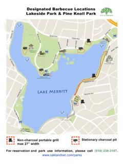
Transcription of INTERACTIVE PLANNING AND ZONING MAP - City …
1 INTERACTIVE PLANNING AND ZONING MAP Page 1 of 7 DISCLAIMER: The information is based on the City's current GIS data. Because the status of layers shown on the map can change, and the GIS data may contain errors, omissions or inaccuracies, the information provided in this map is for reference only, not intended for any other use and should not be relied on for any other purpose. In rare cases, some parcels are mapped in multiple ZONING districts. The map application cannot recognize more than one ZONING district when displaying parcel information (either on the Complete Parcel Information page or the initial pop-up window), so it is recommend to look at the map to see if your property might be in more than one ZONING district.
2 To obtain the latest information on the area(s) or subject parcels of your interest, or to confirm the ZONING which you see on this map, please contact the ZONING Information Hotline at (510) 238-3911. Updated November 2012 The PLANNING and ZONING Division, with assistance from Department of Information Technology, developed a new map application for the public to search land use, ZONING and other information for the City of Oakland. The newly developed map application enhances the user experience with a better user interface and faster speed. The information, however, is based on the City's current GIS data. Because the status of layers shown on the map can change, and the GIS data may contain errors, omissions or inaccuracies, the information provided in this map is for reference only, not intended for any other use and should not be relied on for any other purpose.
3 In rare cases, some parcels are mapped in multiple ZONING districts. The map application cannot recognize more than one ZONING district when displaying parcel information (either on the Complete Parcel Information page or the initial pop-up window), so it is recommend to look at the map to see if your property might be in more than one ZONING district. To obtain the latest information on the area(s) or subject parcels of your interest, or to confirm the ZONING which you see on this map, please contact the ZONING Information Hotline at (510) 238-3911. INTERACTIVE PLANNING AND ZONING MAP Page 2 of 7 DISCLAIMER: The information is based on the City's current GIS data.
4 Because the status of layers shown on the map can change, and the GIS data may contain errors, omissions or inaccuracies, the information provided in this map is for reference only, not intended for any other use and should not be relied on for any other purpose. In rare cases, some parcels are mapped in multiple ZONING districts. The map application cannot recognize more than one ZONING district when displaying parcel information (either on the Complete Parcel Information page or the initial pop-up window), so it is recommend to look at the map to see if your property might be in more than one ZONING district. To obtain the latest information on the area(s) or subject parcels of your interest, or to confirm the ZONING which you see on this map, please contact the ZONING Information Hotline at (510) 238-3911.
5 Updated November 2012 Please read below to find out how to use the INTERACTIVE PLANNING and ZONING Map to learn land use, ZONING and other information for the City of Oakland. 1. Navigate and Zoom Like any other map application available online , Google Map and Bing Map, the INTERACTIVE ZONING and PLANNING Map can be navigated by click and drag the Map. Also, the map can be zoomed in and out by scrolling the mouse up and down. An alternative way to navigate and zoom is by using the compass shown on the lower left corner of the Map. Click the N, S, E and W buttons on the compass to navigate around the map incrementally, and use the zoom bar (use your mouse to move the toggle up and down) to zoom in and out of the map.
6 INTERACTIVE PLANNING AND ZONING MAP Page 3 of 7 DISCLAIMER: The information is based on the City's current GIS data. Because the status of layers shown on the map can change, and the GIS data may contain errors, omissions or inaccuracies, the information provided in this map is for reference only, not intended for any other use and should not be relied on for any other purpose. In rare cases, some parcels are mapped in multiple ZONING districts. The map application cannot recognize more than one ZONING district when displaying parcel information (either on the Complete Parcel Information page or the initial pop-up window), so it is recommend to look at the map to see if your property might be in more than one ZONING district.
7 To obtain the latest information on the area(s) or subject parcels of your interest, or to confirm the ZONING which you see on this map, please contact the ZONING Information Hotline at (510) 238-3911. Updated November 2012 2. Search Address Using the Parcel Search located on the top left corner, search property location. You must click Search button after entering the property address information in order for the Map to search and locate the property. There are three different ways to locate property: Street Address ( 250 Frank H. Ogawa Plaza) Enter a street address in the address bar, located on the top left corner of the screen, and click the search button.
8 The Map will display a marker on the street closest to the parcel. Please click the parcel to find out more information. Sometimes, when the search results in more than one location, the Map will display the Address Candidates pop-up window in the lower right corner. If the pop-up shows up for your search, please click one of candidates to make the map take you to the correct location. Intersecting Streets A particular location can be found by using two intersecting streets nearby the subject property. When searching, using two intersecting streets, use the ampersand character ( & ) between two streets, like this: Broadway & 14th Street.
9 Parcel Number To search property by its assessor parcel number (APN), click the radio button APN to switch the search mode. Then, you can search properties by putting the parcel number in the search box in Alameda County format ( 3-67-1). The resulting map will automatically highlight the parcel and show property information of that particular parcel in a pop-up window. INTERACTIVE PLANNING AND ZONING MAP Page 4 of 7 DISCLAIMER: The information is based on the City's current GIS data. Because the status of layers shown on the map can change, and the GIS data may contain errors, omissions or inaccuracies, the information provided in this map is for reference only, not intended for any other use and should not be relied on for any other purpose.
10 In rare cases, some parcels are mapped in multiple ZONING districts. The map application cannot recognize more than one ZONING district when displaying parcel information (either on the Complete Parcel Information page or the initial pop-up window), so it is recommend to look at the map to see if your property might be in more than one ZONING district. To obtain the latest information on the area(s) or subject parcels of your interest, or to confirm the ZONING which you see on this map, please contact the ZONING Information Hotline at (510) 238-3911. Updated November 2012 3. Property Information Clicking on a parcel will highlight the selected parcel with a red outline, and the Map displays a small pop-up window with parcel information.