Transcription of How To Customize Your Online Property Map
1 How To Customize your Online Property Map By: Joseph Elfelt This information will show you how to Customize an Online Property map that you purchase from us by adding your own information. The link below is an example of a customized Property line map. Click each symbol to see a balloon with more information. You can also click the light blue line but not the other lines. e/propertylinemaps/p/ Don't be spooked by this just because it is computer stuff. I am going to walk you though it. Note: The best way to copy data from this pdf file is to first download this file to your computer and then open the file from your harddrive. If you let your browser open this file and then try to copy something you might get a bunch of highly annoying line breaks.
2 Note: You should see four equal signs in the above link. If you do not, then download this file to your harddrive and open it with adobe acrobat. There are two kinds of information you can add to the map: 1. Symbols. These are small jpg or png images. Symbols can display a popup balloon with information when they are clicked. 2. Lines. You can make lines that are any color and any width. You can also make dashed lines. In general, here are the steps needed to Customize your map. 1. Convert your approximate Property corner coordinates into a text ( txt) file. 2. Put this original text file Online and display it. I will give you step-by-step instructions for using Google Sites which provides free hosting.
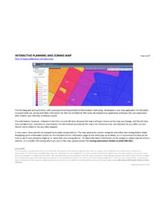
3 3. Add waypoints to your text file. 4. Add lines to your text file. 5. Put your edited text file Online and display your custom map. Below are details for each step. 1. Convert your approximate Property corner coordinates into a text file Below is an Online map I made up for around 160 acres. This land is actually part of a state forest in Michigan. I am making up the data that I am going to add to this map. None of this data is real! If you purchase our service then one thing you will receive will be an Online map link like the following except your coordinate data will be different. Coordinates_are_approximate||description =plm2||label=on||line=on|| , ^1||44.
4 532916, ^2|| , ^3|| , ^4|| , 0^1. Copy and paste your Online map link into any kind of editing program that lets you make text ( txt) files. Personally I use the program Notepad++ (only available for PCs.) This is *not*. the notepad program that comes with windows. Divide your Online map link into two parts like so: Part 1: Part 2: &markers=//Not_a_survey___Coordinates_ar e_approximate||description=plm2||label=o n||line=on || , ^1|| , ^2|| , ^3|| , 3689^4|| , ^1. Part 1 starts the Gmap4 enhanced Google map viewer that I developed and provides a few parameters that control how the map looks when it opens on your screen. To see all the various parameters that you can include in a Gmap4 link, please go to the Gmap4 Help page and download the pdf file Link Parameters.
5 Part 2 includes the coordinate data that produces your approximate Property lines. The characters || represent the end of a line. The character ^ separates different fields of information. The characters // mark a comment line. Blank lines are OK. Break part 2 of your Online map link into separate lines as follows. Do not include the word markers . 2. //Not_a_survey___Coordinates_are_approxi mate description=plm2. label=on line=on , ^1. , ^2. , ^3. , ^4. , ^1. Save just the above part 2' lines as a text file. Give your file a name that does not have any spaces. Use an underline character instead of a space. I named the above file Tip: Online Property maps purchased from us include the statement Not a survey in the upper left corner and have a link titled About this map.
6 In order for that same information to appear on your customized Property map, your text file must include the following line: //Not_a_survey___Coordinates_are_approxi mate 2. Put this original text file Online and display it Before starting to Customize your data, I recommend you put your original text file Online so you get comfortable with that process. For step-by-step instructions for using free Google Sites to host your text file, please go to the Gmap4 Help page and download the pdf file Working With Files . Search that file on Google Sites . When I put the above text file Online using Google Sites, I got the following download link: I eliminated everything after txt so now the link pointing to my text looks like: Now modify Part 1 of your Online map link so it looks like: Paste the link to your text file over the underline.
7 Now your link looks like: e/propertylinemaps/p/ Check to make sure there are no spaces in the above link. Paste the above link into a browser. You should see the same Online map that you see when all the data for the map is part of the Gmap4 link. 3. 3. Add waypoints to your text file Below is the same text file that I showed you above, but with some edits added. The edits are discussed below. I named this file //Not_a_survey___Coordinates_are_approxi mate // =============================. // Symbol table // =============================. symbol= name=corner symbol= name=feature symbol= name=camp //. // =============================. // Approximate Property lines // =============================.
8 Label=on line=on , ^1^^corner , ^2^^corner , ^3^^corner , ^4^^corner , ^1. // The last coordinate is the same as the first one. This closes' the Property boundary. // =============================. // Waypoints // =============================. label=off line=off , ^ Tree stand^ <em> , </em> <br>This stand is 15 feet off the ground with good views of the trail in both directions^ feature , ^ Beaver dam^ <em> , </em> <br>Wildlife come here to drink late in the summer after other water sources have dried up^ feature , ^ Cabin^ <em> , </em> <br>This cabin sleeps 6. There is no electricity. Water comes from a hand pump and the bathroom in an outhouse.
9 ^ camp Below is a Gmap4 link that displays the above text file. You can click the three symbols that were added to the map and a popup will appear. e/propertylinemaps/p/ The file has the following edits. 4. A. Use comment lines to add section headings Adding comments to your text file will help you remember how your text file is organized. Any line that begins with // is a comment line. B. Delete the line: description=plm2. The line description=plm2 is a special command that tells the Gmap4 program to always use a small light blue square for every symbol on the map. Since you want to Customize your map you need to delete this line from your text file.
10 C. Add a symbol table Each different png or jpg symbol that you want to use on your map needs to have one line in the symbol table. Each line in the symbol table looks like: symbol=_____ name=_____. Replace the first underline with the http link to where your image file (png or jpg) is Online . Replace the second underline with a short name that you make up. Here is a webpage that contains links to many symbols that Google is hosting. The get the http link for any symbol, rightclick the symbol and select copy link location . I like the small symbols at the bottom of the above page. For example the small black star on a green background is Online at: You can also download any of the symbols on the above page and then upload them to your Google Sites account.