Transcription of John Muir Trail Itinerary locations: Inyo National Forest ...
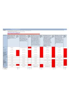
1 Listed from North to South. Itinerary locations are general area you plan to camp, not specific and elevation are approximate for trip planning, not intended for , resupply points, and trails near access roads are in BOLDJMT Southbound from Happy IslesPCT Northbound from Mexico BorderJMT Mile LandmarkItinerary Location NameNotesPCT Mile 0 Happy Isles, Yosemite Valley the north end of the John Muir Trail 4 to 9 Yosemite - John Muir Trail - Little YosemiteLittle Yosemite Valley to Sunrise Creek13 to 17 Yosemite - Cathedral LakesSunrise Trail junction, High Sierra Camp to Tuolumne.
2 To 37 Yosemite- Tuolumne Meadows/ Lyell CanyonTuolumne Meadows to Donohue Pass, inc. Lyell Canyon. - 94237 Donohue Pass: 11,050 ft. elevation. Yosemite / Inyo NF boundary Meadows JMT- (Rush creek )927 Rush creek Trail , miles to June Lakes Loop Pass JMT- Thousand Island LakeUpper Rush creek , south of Donohue Pass9244343 Thousand Island Lake JMT- (River & High Trail ) JMT - PCT separate, rejoin at Devils Lake JMT- Thousand Island LakeOn JMT near Agnew Meadows44 Ruby Lake JMT- Thousand Island LakeOn JMT near Agnew Lake JMT- Thousand Island LakeOn JMT near Agnew Meadows48 Shadow creek Trail , mi.
3 To Agnew Meadows, Reds Meadow creek & JMT (Shadow creek Trail )On JMT near Agnew Meadows50 Rosalie Lake (JMT- North of Devils Postpile)On JMT north of Devils Postpile51 Gladys Lake (JMT- North of Devils Postpile)On JMT north of Devils Lakes (JMT- North of Devils Postpile)On JMT north of Devils Postpile55 Johnston Meadow (JMT- North of Devils Postpile)On JMT north of Devils Postpile and Reds Meadow, shuttle bus, store, Muir Trail Itinerary locations: Inyo National Forest - Wilderness PermitsNot on PCTNo Camping along PCT from Devils Postpile to Agnew Meadows. Use area Pass: 10,225 ft.
4 ElevationHigh Trail / River Trail , 7 miles to Agnew Meadows, Reds Meadow Road Meadow, store, mail, bus stop for YARTS bus (Highway 120). No Camping within 4 miles of Highway Southbound from Happy IslesPCT Northbound from Mexico BorderJMT Mile LandmarkItinerary Location NameNotesPCT Mile 61 Red Cones Trail (Mammoth Pass), mi. to Mammoth Lakes Meadow, Upper (JMT South of Devils Postpile)nearest camp location to Reds creek JMT Junction (South of Devils Postpile)901 Duck Pass Trail , 7 miles to Mammoth Lakes Road68 Duck creek JMT Junction (Duck Pass)no camping at Duck Lake Lake JMT (Duck Pass)no camping at Purple Lake , Lake JMT (Duck Pass)
5 Hole JMT- Upper Cascade/McGee Passincludes Upper Fish creek between Tully Hole and McGee Pass887 -889 McGee Pass Trail , miles to McGee creek Lake JMT- Silver Divideincludes Goodale Trail junction, Papoose Lakes88678 Lake of the Lone Indian JMT- Silver Divide88678 Warrior Lake JMT- Silver Divideno campsites at Squaw Pass Lake JMT- north of Lake Pass creek JMT- north of Lake Edison88385 Mono Pass Trail junction, 15 mi. to Rock creek Road via Mono Meadows JMT-Mono creek (Lake Edison)Near Lake Edison -Vermilion Resort (VVR) resupply, mail87797 Bear creek Meadows, Upper JMT- (Lake Edison)no camping within 2 miles south of Bear creek Trail junction 86997 Rosemarie Meadow JMT- Seldon Lake JMT- Seldon Pass86799 Marie Lake JMT- Seldon Lake JMT- Sallie Keys near Florence Lake865102 Sallie Keyes Lakes JMT near Florence Lake864104 Senger creek JMT- Sallie Keys near Florence Lake862 Silver Pass: 10,950 ft.
6 ElevationSeldon Pass: 10,900 ft. elevationJMT Southbound from Happy IslesPCT Northbound from Mexico BorderJMT Mile LandmarkItinerary Location NameNotesPCT Mile 108 Muir Trail Ranch: mail resupply. Camping not recommended at Blayney109 San Joaquin-JMT PiuteCreekSan Joaquin /Muir Trail Ranch 856110 Piute Pass Trail junction, 17 mi. to North Lake Road, 20 mi to Pine Creek856110 to 114 SEKI - Goddard (28)Aspen Meadow & Goddard creek Junction851 to 855114 to 121 SEKI - McClure Meadow (33)Evolution Valley, McClure, and Colby Meadows845 to 851121 to 127 SEKI - Evolution Basin (34)Evolution Lake, Wanda Lake, to Muir to to 140 SEKI - LeConte Canyon (39)Helen Lake, Big Pete, Grouse, and Deer Meadow822 to Pass Trail junction, 10 miles to South Lake831 SEKI - Dusy Basin (42)between Bishop Pass and LeConte 140 to149 SEKI - Palisade Basin (45)
7 Palisade Lakes to MatherPass 817to to 159 SEKI - Upper Basin(46)Mather Pass to Pinchot Pass; SF Kings River, Lake Marjorie807 to 817155 Taboose Pass Trail junction, miles to trailhead810159807159 to 166 SEKI - Twin Lakes (56)Pinchot Pass to Castle Domes; upper Woods to Pass Trail junction, miles to to171 SEKI-Woods creek JCT(58)Woods creek , south fork Pass Trail junction, 13 miles to to - Rae Lakes (62)Dollar Lake to Glen Pass, including Rae Lakes. 1 night limit per to Pass Trail junction, miles to Onion Valley *SEKI - Kearsarge Lakes(64)No camping at Bullfrog to 179 SEKI - Charlotte Lake (63)Glen Pass to south of Kearsarge trail787 to creek Trail junction, 12 miles to Roads End in Kings Canyon NP787 SEKI - Bubbs creek (66)Junction Meadow, Bubbs creek Trail to Cedar Grove-Roads Endnot on PCT179 to 187 SEKI - Center Basin -Vidette (65)Vidette Meadow to Forester to to 195 SEKI - Tyndall creek (80)Forester Pass to Bighorn Plateau.
8 Shepherd Pass junction773 to Pass Trail junction, 13 miles to to 200 SEKI - Wallace creek (81)Wallace creek drainage 770to 773203 SEKI - crabtree (83) Lake, Whitney creek , PCT from Sandy Meadow to Guyot763 to 770 Muir Pass: 11,955 ft. elevationMather Pass: 12,080 ft. elevationPinchot Pass: 12,100 ft. elevation Glen Pass: 11,980 ft. elevationForester Pass: 13,200 ft. elevationJMT Southbound from Happy IslesNorthbound from Whitney PortalJMT Mile LandmarkItinerary Location NameNotesNOBO Mile 203 PCT -JMT junctionSEKI - crabtree (83)Summit of to crabtree , including Guitar Muir Trail junction (2 miles to the summit; miles to PCT) of Mt Whitney is south end of JMT ( miles from PCT) Muir Trail junction (2 miles to the summit; miles to PCT) Crest elevation 13,600 ft.
9 ( miles to the summit) Camp ( Trail )12,000 ft. level below the 99 switchbacks; 6 miles to Lake ( )11,000 ft. Camp ( Trail )10,400 ft. level; 4 miles to TH4220 Lone Pine Lake ( Trail )9,900 ft. level; 3 miles to Whitney Portal Whitney Trailhead at end of Whitney Portal Road0 Southbound from JMT/PCT junctionPCT Northbound from Mexico BorderSOBO Mile LandmarkItinerary Location NameNotesPCT Mile 0 crabtree Meadows PCT / JMT junction ( miles to Mt Whitney summit)7670 - 3 SEKI - crabtree (83)Sandy Meadow to Guyot, includes crabtree , Whitney creek , and Guitar Lake763 to 7703 - 13 SEKI - Rock creek (84)Rock creek Canyon to Guyot754 to Spring Lake (PCT- Cottonwood Pass)Golden Pass: 11,140 ft.
10 Elev, miles to Horseshoe Meadows Pass Trailhead at Horseshoe Meadow RoadSequoia National Park boundaryMt Whitney Trail : Summit to Whitney Portal ( Trail Crest Exit)Alternate route to John Muir Trail via Pacific Crest Trail adds 20-33 milesPCT Northbound from Mexico BorderSOBO Mile LandmarkItinerary Location NameNotesPCT Mile Pass: 11,140 ft. elev, miles to Horseshoe Meadow PCT- Golden Trout WildernessGolden Trout7472 Trail Pass: 10,050 ft. elevation. 2 miles to Horseshoe Meadows Road7454 Dutch Meadow (PCT)- Golden Trout WildernessGolden creek (PCT)- Golden Trout WildernessGolden Meadow (PCT)- Golden Trout WildernessGolden Trout73916 Death Canyon (PCT)- Golden Trout WildernessGolden Trout73118 Big Dry Meadow (PCT) - Golden Trout WildernessGolden Trout72919 Gomez Meadow (PCT)- Golden Trout WildernessGolden Trout72821 Buck Meadow (PCT)- Golden Trout WildernessGolden Trout72626 Brush Meadow PCT- (Olancha Pass)South Sierra72127 Bear Trap Meadows PCT- (Olancha Pass)South Sierra72028 Cow Canyon PCT- (Olancha Pass)