Transcription of Map Scales - USGS
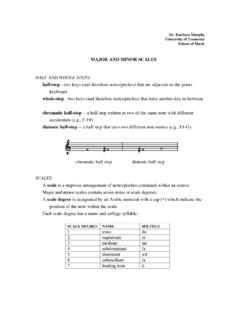
1 The proportion chosen for a particularmap is its scale . Selecting the appropriatescale depends on the size of the sheet ofpaper and the accurate placement offeatures. Ground area, rivers, lakes,roads, distances between features, and soon must be shown proportionately smallerthan they really are. LLaarrggee IIss SSmmaallllSimply defined, scale is the relationshipbetween distance on the map and distanceon the ground. A map scale usually isgiven as a fraction or a ratio 1/10,000 or1:10, "representative fraction" scalesmean that 1 unit of measurement on themap 1 inch or 1 centimeter represents10,000 of the same units on the the scale were 1:63,360, for instance,then 1 inch on the map would represent63,360 inches, or 1 mile, on the ground(63,360 inches divided by 12 inchesequals 5,280 feet, or 1 mile).
2 The firstnumber (map distance) is always 1. Thesecond number (ground distance) isdifferent for each scale ; the larger thesecond number is, the smaller the scale ofthe map. "The larger the number, thesmaller the scale " sounds confusing, butit is easy to understand. A map of an area100 miles long by 100 miles wide drawnat a scale of 1:63,360 would be more than8 feet square. To make the map a moreconvenient size, either the scale used orthe area covered must be the scale is reduced to 1:316,800, then 1 inch on the map represents 5 miles onthe ground, and an area 100 miles squarecan be mapped on a sheet less than 2 feetsquare (100 miles at 5 miles to the inchequals 20 inches, or feet).
3 On theother hand, if the original 1:63,360 scaleis used but the mapped area is reduced to20 miles square, the resulting map willalso be less than 2 feet maps would be easier to would they be more useful? In thesmall- scale map (1:316,800), there is lessroom; therefore, everything must bedrawn smaller, and some small streams,roads, and landmarks must be left outaltogether. On the other hand, the largerscale map (1:63,360) permits more detailbut covers much less areas have been mapped atdifferent Scales . The most important consideration in choosing a map is itsintended use.
4 A town engineer, forinstance, may need a very detailed map tolocate precise sewers, power and waterlines, and streets. A commonly usedscale for this purpose is 1:600 (1 inch onthe map represents 50 feet on theground). This scale is so large that manyfeatures such as buildings, roads, andrailroad tracks can be drawn to scaleinstead of being represented by GGeeoollooggiiccaall SSuurrvveeyy SSccaalleess The Geological Survey (USGS)publishes maps at various Scales . Thescale used for most topographicmapping is 1:24,000.
5 USGS maps at thisscale cover an area measuring of latitude and minutes oflongitude and are commonly called quadrangle maps. Map coveragefor most of the United States has beencompleted at this scale , except for PuertoRico, which is mapped at 1:20,000 and1:30,000, and for a few States that havebeen mapped at 1:25,000. Most ofAlaska has been mapped at 1:63,360,with some populated areas also mappedat 1:24,000 and 1:25, at 1:24,000 scale are fairly largeand provide detailed information aboutthe features of an area, including thelocations of important buildings and Department of the Geological SurveyMMaapp SSccaalleessUSGS Fact Sheet 015-02 February 20021:500,000- scale map1:63,360- scale map1:20,000- scale mapcampgrounds, ski lifts, and water , drawbridges, fence lines,and private roads are also shown at thisscale.
6 Usually these features are omittedfrom maps in the 1:50,000- to 1:100,000- scale range; these maps cover more areawhile retaining a reasonable level ofdetail. Maps at these Scales are most oftenproduced using the 30- by 60-minutequadrangle maps (1:250,000 and smaller)show large areas on single map sheets, but details are limited to major features,such as boundaries, parks, airports, majorroads, railroads, and table below shows information aboutmaps available from the USGS. Forinformation on other USGS products andservices, call 1-888-ASK-USGS, use fax service, which isavailable 24 hours a day at 703-648-4888,or visit the general interest publicationsWeb site on mapping, geography, andrelated topics at additional information, visit Web site or the USGS homepage at :24,000- scale map1:100,000- scale map1:250,000- scale mapPuerto Rico minute1:20,0001,667 feet 200 by minute1:24,0002,000 feet (exact)240 by minute49 to minute1.
7 25,0002,083 feet 250 by minute49 to 70 by 15 minute1:25,0002,083 feet 250 by 15 minute98 to 140 USGS-DMA 15 minute1:50,0004,166 feet500 meters15 by 15 minute197 to 28215 minute*1:62,5001 mile 625 meters15 by 15 minute197 to 282 Alaska Maps 1:63,3601 mile (exact) meters 15 by 20 to 36 minute207 to 281 County Maps 1:50,0004,166 feet 500 metersCounty areaVariesCounty Maps1:100, miles 1 kilometerCounty areaVaries30 by 60 minute1:100, miles 1 kilometer30 by 60 minute1,568 to 2,24030 minute*1:125,0002 kilometers30 by 30 minute786 to 1,1241 degree by 2 degrees or 3 degrees 1:250,0004 miles kilometers1 by 2 or 3 4,580 to 8,669 State Maps 1:500,0008 miles 5 kilometersState areaVariesState Maps 1:1,000,00016 miles 10 kilometersState Sectional Maps1:2,000,00032 miles 20 kilometersState groupsVariesAntarctica Maps 1:250,0004 miles kilometers1 by 3 to 15 4,089 to 8,336 Antarctica Maps 1.
8 500,0008 miles 5 kilometers2 by 28,174 to 30,462* Abandoned map series, but still available for ordering as black-and-white photographic MMaappssSSttaannddaarrddQQuuaaddrraanngg llee11 iinncchh rreepprreesseennttss11 cceennttiimmeetteerrqquuaaddrraannggllee ssiizzeeaarreeaaSSeerriieessSSccaalleeaa pppprrooxxiimmaatteellyyrreepprreesseenn ttss((llaattiittuuddee bbyy lloonnggiittuuddee))((ssqquuaarree mmiilleess))