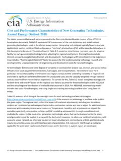
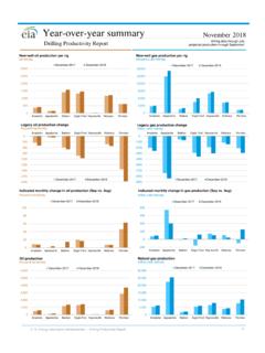
Transcription of Marcellus Shale Play - Energy Information Administration
1 Marcellus Shale Play Geology review 2017. Independent Statistics & Analysis Department of Energy Washington, DC 20585. This report was prepared by the Energy Information Administration (EIA), the statistical and analytical agency within the Department of Energy . By law, EIA's data, analyses, and forecasts are independent of approval by any other officer or employee of the United States Government. The views in this report therefore should not be construed as representing those of the Department of Energy or other federal agencies. EIA author contact: Dr. Olga Popova Email: Energy Information Administration | Updates to the Marcellus Shale Play Maps i January 2017. Introduction The Energy Information Administration (EIA) is adding and updating geologic Information and maps of the major tight oil and Shale gas plays for the continental United States.
2 This document outlines updated Information and maps for the Marcellus play of the Appalachian basin. The geologic features characterized and updated since the 2011 Marcellus Shale play map include contoured elevation of the top of formation (structure), contoured thickness (isopach), paleogeography elements, and tectonic structures (regional faults and folds etc.), as well as play boundaries, well location, and initial wellhead yields (oil-to gas-ratios) of wells producing from January 2000 through December 2016. These geologic elements are documented and integrated into a series of maps. The Marcellus play map consists of layers of geologic and production Information that users can view either as separate thematic maps (such as Figure 1) or as interactive layers of the Energy Mapping System.
3 Data sources include DrillingInfo Inc. (DI, a commercial oil and gas well database), the United States Geological Survey (USGS), New York State Geological Survey, Ohio State Geological Survey, Pennsylvania Bureau of Topographic &. Geologic Survey, West Virginia Geological & Economic Survey, EIA reports, peer-reviewed research papers, and academic theses. Currently, EIA's access to well-level data is limited, and EIA is working to expand its well-level data to include well-log representation. Additional map layers will be added as additional geologic data (such as petrophysical and thermodynamic formation properties) become available. The Marcellus formation extent in the Appalachian basin and Play boundaries The Marcellus Middle Devonian-age organic-rich formation, also known as Marcellus Shale , extends in the subsurface from New York State in the north to northeastern Kentucky and Tennessee in the south and is the most prolific natural gas-producing formation in the Appalachian basin.
4 The formation footprint covers about 95,000 square miles with a prospective area about 72,000 square miles. The Marcellus formation includes the Upper Marcellus and Lower Marcellus intervals. The Lower Marcellus has a significantly higher organic matter concentration compared with the Upper Marcellus . Recorded high spectral gamma-ray log values of the Lower Marcellus are indicative of the abundant Total Organic Carbon (TOC). Overall Marcellus structure and thickness are influenced by the basement tectonics patterns. EIA. estimates proven reserves in the Marcellus Play of trillion cubic feet (Tcf) at year end 2015 which makes it one of the largest natural gas plays in the The Marcellus has oil reserves of 143 million barrels (MMbbls).
5 The Marcellus play footprint extends across five states: New York, Pennsylvania, Ohio, West Virginia, and Kentucky. Like with other continuous plays, key geologic and technical criteria that control play boundaries include thermal maturity, total organic carbon (TOC), formation thickness, porosity, depth, pressure, and the ability to be fractured. The boundaries of the Marcellus formation (Figure 1) are outlined to the north, south, and east by the outcrop belt of the formation and to the west by the pinching out of the Marcellus by the Middle Devonian Unconformity buried in the subsurface. The northwest boundary of the Marcellus Play is Energy Information Administration | Updates to the Marcellus Shale Play Maps 1.
6 January 2017. roughly defined by the end of the oil window and the beginning of the immature area, and the southeast boundary is defined by the end of the gas window ends and the beginning of the over-mature area, according to a study that used thermal maturity modeling calibrated to published vitrinite reflectance (%Ro) data (East et al., 2012). The limits of the oil window correlate to the subsea depth range of 1,000- 5,000 feet, and the limits of the gas window correlate to the subsea depth range of 3,000- 6,500 feet. The change in depth in relation to maturity reflects the amount of differential subsidence within the Appalachian basin and subsequent uplifeet and erosion with certain basement blocks.
7 Structure map of the Marcellus formation Contoured elevation maps or subsea depth to the top of a geologic formation (also called structure maps) are constructed from two types of data: (1) point-measurement depth data referenced to sea level (well observations) for areas where a formation is located in subsurface, (2) and elevation data of formation outcrops that provide the third dimension for characterizing depth or elevation of a reservoir on an otherwise two-dimensional map. Figure 1. Structure map of the Marcellus formation Source: Energy Information Administration based on DrillingInfo Inc., New York State Geological Survey, Ohio State Geological Survey, Pennsylvania Bureau of Topographic & Geologic Survey, West Virginia Geological & Economic Survey, Geological Survey.
8 Energy Information Administration | Updates to the Marcellus Shale Play Maps 2. January 2017. To generate the structure map (Figure 1), EIA used stratigraphic correlations provided by state geological survey agencies based on well log interpretation from 2,416 wells. The top of the Marcellus formation ranges in elevation from 1,000 feet to -8,000 feet subsea depth (measured depth from 100 to 9,900 feet) and primarily produces gas in northeast Pennsylvania, but becomes more liquids-rich in less thermally mature areas of southwestern Pennsylvania, West Virginia, and southeastern Ohio. As the structure map shows, the Appalachian basin is an asymmetric depression. The depth of the Marcellus formation increases gradually from northwest to southeast, with an abrupt uplift along the Appalachian Mountains structural front where it forms an outcrop belt.
9 The deepest portion of the Marcellus Shale is related to the synclines adjacent to the structural front. Most of the producing wells are located in areas where the subsea depth of the formation is in the -2,000 to -6,000 foot interval. The Marcellus currently produces in four states: Pennsylvania, West Virginia, Ohio, and New York. Because of the recent ban on hydraulic fracturing in New York, natural gas production in New York State is from wells drilled prior to the ban in 2010. Thickness (isopach) map of the Marcellus formation Thickness maps (isopachs) show spatial distribution of formation thickness across the formation Figure 2. Isopach map of the Marcellus formation Source: Energy Information Administration based on DrillingInfo Inc.
10 , New York State Geological Survey, Ohio State Geological Survey, Pennsylvania Bureau of Topographic & Geologic Survey, West Virginia Geological & Economic Survey, Geological Survey. Energy Information Administration | Updates to the Marcellus Shale Play Maps 3. January 2017. footprint. Thickness values are used, in combination with reservoir petrophysical properties such as porosity and thermodynamic parameters (reservoir temperature and pressure), to calculate resource volumes, such as oil-in place and gas-in-place estimates. The isopach map for the Marcellus formation (Figure 2) is constructed from subsurface point measurements from individual wells that include both depth to the top and to the base of the Marcellus formation.