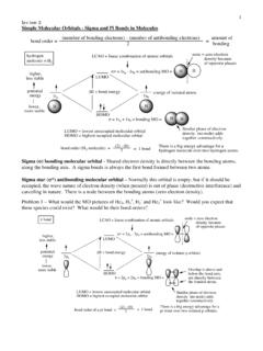
Transcription of MONUMENTS AND ACCESSORIES - cpp.edu
1 MONUMENTS AND ACCESSORIES INTRODUCTION The basic purpose of land surveys is marking corners in their proper locations with materials that will withstand the ravages of time and the elements. Each marker must be placed in accordance with the method of instructions and procedures outlined in the Manual of Instructions in use at the time of the survey. The manual has been reprinted several times and many changes have been made through the years. The modern surveyor recognizes these variations and makes appropriate notations in his records of survey. MONUMENTS The Bureau of Land Management has standardized the marking of corners used in present-day surveys.
2 All types of corner MONUMENTS are systematically marked to furnish identification of the monument . However, it is possible you may encounter MONUMENTS placed many years ago, which do not conform to current practice. POST AND TREE MONUMENTS Figure 1 Commonly Used Markings The usual wrought iron post monument carries a brass cap. Identifying letters and numbers are stamped on this cap with a stamping set. Similar letters and numbers are marked on tree MONUMENTS , on the trunk just above the root crown, using a timber scribe. If the tree is smooth-barked, the markings are cut directly into the bark; if it is rough-barked, a long blaze is made on the trunk to receive the markings.
3 Figure 1 is a list of the commonly used markings that apply to all classes of corners. The marking on the brass cap is made to read from the south side. Figure 2 Corner Markings Figure 2 shows how these marks are used in a number of typical situations. Older corner MONUMENTS are shown in figure 3. Figure 3 Older Corner Markings STONE MONUMENTS Where stone MONUMENTS are used, the letters, numbers, and other markings are chiseled into one or more of the vertical faces of the stone rather than upon its top. Stone MONUMENTS are set with either their faces or their edges in the cardinal directions, depending upon the location of the corner in the survey.
4 Stone township corners bear the letters and numbers indicating the townships and ranges to which the monument is common. If the monument is on a base line or standard parallel, it must also show the letters SC or CC to distinguish between standard and closing township corners. Section corners are likewise distinguished as standard or closing corners. In addition, they bear a number of grooves on the faces or a number of notches on the edges of the monument . These grooves or notches indicate, for exterior section corners, the number of miles from the monument to the adjoining township corners.
5 Figure 4 Stone Markings For subdivision corners, they show the number of miles from the monument to the east and south township boundary lines (Figure 4), furnishing a means of identifying the sections, which meet at the monument . MEANDER CORNERS All navigable bodies of water and other important rivers and lakes are segregated from the public lands at mean high-water level. Where section lines, quarter-section lines, or sixteenth lines meet the bank of a meanderable stream or lake, a marker is placed. These locations are termed "meander corners," "special meander corners," or "auxiliary meander corners.
6 " The distance from the nearest section or quarter section monument on the survey line is measured and recorded. The monument is marked on the side facing the water. The other markings that refer to township, sections, and date of establishment are also stamped or chiseled. Such a monument is referenced by bearings to trees or other convenient witnesses. Where the width of the watercourse permits, the survey line is carried across to a meander corner on the far shore. Figure 5 Meander Corners In Figure 5, corners a and b are meander corners; c and d are special meander corners; and e, at a given distance and direction from the section corner, is an auxiliary meander corner.
7 Standard terms used in land surveys commonly are abbreviated by the use of their initials: AMC: Auxiliary Meander Corner BO: Bearing Object BT: Bearing Tree CC: Closing Corner SC: Standard Corner WC: Witness Corner MC: Meander Corner SMC: Special Meander Corner RESPONSIBILITY FOR PERPETUATION OF CORNERS OF THE PUBLIC LAND SYSTEM OF SURVEYS The following paragraphs taken from a directive published by the Bureau of Land Management should be of interest to all surveyors: The law provides that the original corners established during the process of survey shall forever remain fixed in position.
8 The courts attach major importance to evidence relating to the original position of the monument . In order to protect the MONUMENTS established by the government in surveying the public lands, Congress on March 4, 1909, enacted legislation providing for a penalty for the unauthorized alteration or removal of such MONUMENTS . This act, although its provisions are seldom invoked, nevertheless serves as a warning to the public and makes the public realize the importance of land boundaries. The Act provides: "Whoever shall willfully destroy, deface, change, or remove to another place any section corner, quarter-section corner, or meander post, on any Government line of survey, or shall willfully cut down any witness tree or tree blazed to mark the line of a Government survey, or shall willfully deface, change, or remove any monument or bench mark of any Government survey, shall be fined not more than $250, or imprisoned not more than six months, or both.
9 " The administration of this law is not a function of the Bureau of Land Management; it being a part of the United States Criminal Code is administered by the Justice Department. Therefore, any complaints coming within the purview of this Act should be filed with the United States Attorney in whose district the offense was committed. The power of making surveys or resurveys of the public land is vested in the Department of the Interior. A licensed surveyor of the State of California has the authority to determine the boundaries of privately owned lands, but his determination of the boundaries between privately owned lands and public lands cannot be accepted when it is evident from the conditions on the ground that the surveyor did not use the proper method or that he disregarded evidence of the original survey.
10 The Bureau of Land Management does not disturb local existing conditions if it is possible to accept corners established by private surveyors. However, since the only right, title, or interest acquired by a patentee to lands of the United States is defined by the corners of the original government survey upon which the description is based, a private surveyor cannot disregard evidence of the original survey or disregard the legal method of subdividing a section and expect to have his survey accepted by all interested parties. Under the California Code, the duties of the Surveyor are clearly established in the perpetuation of government survey markings.