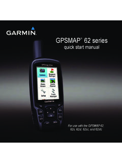
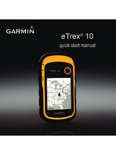
Transcription of owner’s manual - Garmin International
1 etrex owner s manualfor use with models 10, 20, 30 2011 Garmin Ltd. or its subsidiariesAll rights reserved. Under the copyright laws, this manual may not be copied, in whole or in part, without the written consent of Garmin . Garmin reserves the right to change or improve its products and to make changes in the content of this manual without obligation to notify any person or organization of such changes or improvements. Go to for current updates and supplemental information concerning the use of this , the Garmin logo, etrex , BlueChart , and City Navigator are trademarks of Garmin Ltd. or its subsidiaries, registered in the USA and other countries.
2 ANT , ANT+ , BaseCamp , chirp , HomePort , and Thumb Stick are trademarks of Garmin Ltd. or its subsidiaries. These trademarks may not be used without the express permission of is a registered trademark of Microsoft Corporation in the United States and/or other countries. Mac is a registered trademarks of Apple Computer, Inc. microSD is a trademark of SD-3C, LLC. Other trademarks and trade names are those of their respective owner s manual 3 Table of ContentsTable of ContentsGetting Started ..5 Device the etrex Keys ..6 Battery Information ..7 Turning the Device On or Off ..8 Satellite Signals ..8 Registering Your Device.
3 8 Waypoints, Routes, and Tracks ..9 Waypoints ..9 Using Sight N Go ..10 Where To? Menu ..11 Routes ..12 Tracks ..14 Navigation ..16 Navigating to a ..17 Elevation Computer ..20 Geocaches ..21 Downloading the Geocache List ..21 Navigating to a Geocache ..22 Logging the ..23 Applications ..24 Sharing a Proximity Alarm ..24 Calculating the Size of an Area ..25 Using the Calculator ..25 Viewing the Calendar and Almanacs ..25 Setting an Alarm ..26 Opening the Stopwatch ..26 Satellite Page ..26 Customizing Your Device ..28 Customizing the Main Menu ..28 Customizing Specific Pages .. Settings ..304 etrex owner s ManualTable of ContentsSetting the Device Tones.
4 31 Map Settings ..32 Changing the Units of Measure ..33 Time Settings ..33 Position Format Settings ..33 Heading Settings ..34 Altimeter Settings ..34 Geocaching Settings ..35 Routing Settings ..36 Marine Map ..38 Resetting Data ..38 Changing the Page Information ..40 Adjusting the Screen ..40 Updating the Software ..40 Viewing Device Information ..40 Specifications ..41 About the Batteries ..41 Caring for the Device ..42 Data Management ..43 Appendix ..46 Optional Accessories ..46 Data Field Options ..47 Troubleshooting ..52 Index ..54eTrex owner s manual 5 Getting StartedGetting Started WARNINGSee the Important Safety and Product Information guide in the product box for product warnings and other important using your device the first time, you should complete these tasks to set up the device and get to know the basic Install the batteries (page 7).
5 2. Turn on the device (page 8). 3. Acquire satellites (page 8).4. Register the device (page 8).5. Mark a waypoint (page 9).6. Create a route (page 12).7. Record a track (page 14).8. Navigate to a destination (page 16).9. Calibrate the compass (page 17).Device Overview Zoom keys Back key Thumb Stick Menu key /Backlight key6 etrex owner s ManualGetting Started Mini-USB port (under weather cap) Battery cover Battery cover locking ring Mounting spineUsing the etrex Keys Move the Thumb Stick up, down, left, and right to highlight menu selections or to move around the map. Press the center of the Thumb Stick to select the highlighted item.
6 Press back to move back one step in the menu structure. Press menu to display a list of commonly-used functions for the current page. Press menu twice to access the main menu from any page. Press and to zoom in and out on the owner s manual 7 Getting StartedBattery Information WARNINGThe temperature rating for the device (-4 F to 158 F, or -20 to 70 C) may exceed the usable range of some batteries. Alkaline batteries can rupture at high Alkaline batteries lose a significant amount of their capacity as temperature decreases. Therefore, use lithium batteries when operating the device in below-freezing AA BatteriesThe device operates on two AA batteries.
7 You can use alkaline, NiMH, or lithium batteries. Use NiMH or lithium batteries for best Turn the D-ring counter-clockwise, and pull up to remove the Insert the batteries, observing Replace the battery cover, and turn the D-ring Hold .5. Select Setup > System > Battery Select Alkaline, Lithium, or Rechargeable etrex owner s ManualGetting StartedTurning the Device On or OffHold .Satellite SignalsAfter the device is turned on, it begins acquiring satellite signals. The device may need a clear view of the sky to acquire satellite signals. When the GPS bars on the backlight page (page 40) are solid green, your device has acquired satellite signals.
8 The time and date are set automatically based on the GPS more information about GPS, go to Your Device Go to Keep the original sales receipt, or a photocopy, in a safe owner s manual 9 Waypoints, Routes, and TracksWaypoints, Routes, and TracksWaypointsWaypoints are locations you record and store in the a WaypointYou can save your current location as a Select Mark Select an option: To save the waypoint without changes, select Done. To make changes to the waypoint, select an item to edit, and select a Waypoint1. Select Where To? > Select a a WaypointBefore you can edit a waypoint, you must create a Select Waypoint Select a Select an item to Enter the new Select a Waypoint1.
9 Select Waypoint Select a waypoint. 3. Select menu > Delete > etrex owner s ManualWaypoints, Routes, and TracksIncreasing the Accuracy of a Waypoint LocationWaypoint averaging allows you to increase the accuracy of a waypoint location by collecting multiple samples of the waypoint location. 1. Select Waypoint Select a waypoint. 3. Move to the location. 4. Select Start. 5. When the Sample Confidence status bar reaches 100%, select Save. For best results, collect four to eight samples for the waypoint, waiting at least 90 minutes between Sight N GoSight N Go is available on the etrex 30. You can point the device at an object in the distance, lock in the direction, and then navigate to the Select Sight N Point the device at an object or in the direction of a Select Lock Direction > Project Waypoint.
10 4. Select a unit of measure. 5. Enter the distance to the object, and select Done > Save. etrex owner s manual 11 Waypoints, Routes, and TracksWhere To? MenuYou can use the Where To? menu to find a destination to navigate to. Not all Where To? categories are available in all areas and maps. Additional MapsYou can use additional maps on the etrex 20 and etrex 30, such as BirdsEye satellite imagery, BlueChart g2, TOPO, and City Navigator detailed maps. Detailed maps may contain additional points of interest, such as restaurants or marine services. For more information, go to or contact your Garmin dealer.