Transcription of Permian Basin - Energy Information Administration
1 Permian Basin Wolfcamp Shale Play Geology review October 2018 Independent Statistics & Analysis Department of Energy Washington, DC 20585 Energy Information Administration | Permian Basin i This report was prepared by the Energy Information Administration (EIA), the statistical and analytical agency within the Department of Energy . By law, EIA s data, analyses, and forecasts are independent of approval by any other officer or employee of the United States Government. The views in this report therefore should not be construed as representing those of the Department of Energy or other federal 2018 Energy Information Administration | Permian Basin 1 Contents Introduction.
2 2 Permian Basin .. 2 Regional tectonic setting and geologic framework .. 2 Regional Stratigraphy .. 4 Paleogeography and depositional environment .. 6 The Wolfcamp formation extent in the Permian Basin .. 8 Structure map of the Wolfcamp formation .. 8 Thickness map of the Wolfcamp formation .. 9 Regional stratigraphy and lithology of the Wolfcamp 10 Total organic carbon content of the Wolfcamp formation .. 10 Wolfcamp formation benches .. 11 Upper Wolfcamp (A and B benches) in the Delaware Basin and play boundaries .. 11 Structure map of Wolfcamp A in the Delaware Basin .. 11 Thickness map of Wolfcamp A in the Delaware Basin .. 12 October 2018 Energy Information Administration | Permian Basin 2 Introduction The Energy Information Administration (EIA) is adding and updating geologic Information and maps of the major tight oil and shale gas plays for the continental United States.
3 This document outlines updated Information and maps for the Wolfcamp play of the Permian Basin . The geologic features characterized include contoured elevation of the top of formation (structure), contoured thickness (isopach), paleogeography elements, and tectonic structures (such as regional faults and folds), as well as play boundaries, well location, and initial wellhead production of wells producing from January 2005 through September 2018. These geologic elements are documented and integrated into a series of maps. The Permian Basin maps consist of layers of geologic and production Information that users can view either as separate thematic maps (such as Figure 1) or as interactive layers of the Energy Mapping System.
4 Data sources include DrillingInfo Inc. (DI), a commercial oil and natural gas well database, the United States Geological Survey (USGS), Texas Bureau of Economic Geology, EIA reports, peer-reviewed research papers, and academic theses. Currently, EIA has access to well-level data, including more than 20,000 well logs from the Permian Basin , which are used for map construction. This report contains the Wolfcamp play section, including subsections on the Wolfcamp A maps in the Delaware Basin . EIA will add spatial layers for structure, thickness, and production maps as well as corresponding report sections describing major plays of the Permian Basin in the future as additional maps are created.
5 Permian Basin The Permian Basin of West Texas and Southeast New Mexico has generated hydrocarbons for about 100 years and supplied more than billion barrels of oil and about 118 trillion cubic feet of natural gas as of September 2018. Implementing hydraulic fracturing, horizontal drilling , and completion technology advancements during the past decade has reversed the production drop in the Permian , and the Basin has exceeded its previous peak in the early 1970s. In 2017, it accounted for 20% of the total crude oil production and about 9% of the total dry natural gas production. For 2016, EIA estimates remaining proven reserves in the Permian Basin to exceed 5 billion barrels of oil and trillion cubic feet (Tcf) of natural gas, making it one of the largest hydrocarbon-producing basins in the United States and the world (EIA, 2017).
6 Regional tectonic setting and geologic framework The Permian Basin is a complex sedimentary system located in the foreland of the Marathon Ouachita orogenic belt. It covers an area of more than 75,000 square miles and extends across 52 counties in West Texas and Southeast New Mexico. The Permian Basin was developed in the open marine area known as the Tobosa Basin in the middle Carboniferous period approximately 325 million 320 million years ago (Galley, 1958). The ancestral Tobosa Basin was formed by an asymmetric structural flexure in the Precambrian basement at the southern margin of the North American plate in late Proterozoic time (Beamont, 1981; Jordan 1981). During consequent phases of Basin development, sediments eroded October 2018 Energy Information Administration | Permian Basin 3 from the surrounding highlands and were deposited in the Basin (Brown et al.)
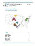
7 , 1973; Dorobek et al., 1991). The Permian Basin is now an asymmetrical, northwest to southeast-trending sedimentary system bounded by the Marathon-Ouachita orogenic belt to the south, the Northwest shelf and Matador Arch to the north, the Diablo platform to the west, and the Eastern shelf to the east (Gardiner, 1990; Ewing, 1991; Hills, 1985). The Basin is comprised of several sub-basins and platforms: three main sub-divisions include the Delaware Basin , Central Basin Platform, and the Midland Basin (Figure 1). Figure 1. Major structural and tectonic features in the region of the Permian Basin Source: Energy Information Administration based on DrillingInfo Inc., Geological Survey.
8 The tectonic history of the Midland and Delaware Basins is mostly affected by uplift of the Central Basin Platform and, to a less degree, by the thrusting of the Marathon-Ouachita orogenic belt. The main phase of the Basin differentiation occurred during Pennsylvanian and Wolfcampian time because of the rapid subsidence in the Delaware and Midland Basins and the uplift of the Central Basin Platform, as shown by sudden changes in thickness and lithology of Pennsylvanian to Permian strata. In the fault zone surrounding the Central Basin Platform, Strawn carbonates unconformably overlie lower to middle Paleozoic strata. This alignment is a stratigraphic indicator that the fault zone along the Central Basin Platform perimeter was tectonically active during late Pennsylvanian time.
9 Because of deferential movements of basement blocks, uplift of the Central Basin Platform created differential subsidence and variable Basin geometry in the adjacent Delaware and Midland Basins. This stage of tectonic activity lasted until the end of the Wolfcampian time, when the fast deformation and subsidence in the sub-October 2018 Energy Information Administration | Permian Basin 4 basins stopped. However, Basin subsidence continued until the end of the Permian (Oriel et al., 1967; Robinson, K., 1988; Yang and Dorobek, 1995). The Delaware Basin is bounded to the north by the Northwestern shelf, to the south by the Marathon - Ouachita fold belt, to the west by the Diablo Platform, and to the east by uplifted areas of the Central Basin Platform separating the Delaware and Midland Basins.
10 An echelon pattern of high angle faults with a large vertical displacement are detected along the boundaries of the Central Basin Platform, which itself is an uplifted, fault-bounded structural high that is primarily carbonate in composition and is highly faulted. The Midland Basin is bounded to the east by the Eastern shelf through a series of north-south trending fault segments and to the north by the Northwest shelf. Southward, Midland Basin formations thin out into the Ozona Arch, an extension of Central Basin Platform, which separates the Delaware and Midland Basins (Figure 1). Regional Stratigraphy The age of sedimentary rocks underling the Permian system in West Texas to Southeast New Mexico ranges from Precambrian to Pennsylvanian.