Transcription of Tropical Cyclone Report - National Hurricane Center
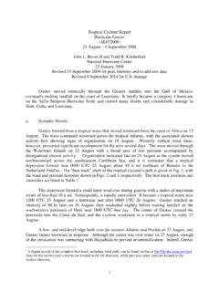
1 Tropical Cyclone Report Hurricane dean (AL042007) 13-23 August 2007 James L. Franklin National Hurricane Center 31 January 2008 Revised 19 February 2008 (for damage statistics in Martinique and Guadeloupe and to add acknowledgments) Revised 7 April 2008 (corrected wind speeds in Table 1 between 16/1200 UTC and 17/0600 UTC) dean was a classic Cape Verde Cyclone that moved through the Caribbean as a major Hurricane , passing very close to jamaica and later making landfall on the east coast of the Yucatan Peninsula as a category 5 Hurricane . dean , the first Atlantic Hurricane since Andrew of 1992 to reach land at category 5 strength, was responsible for 32 deaths. a. Synoptic history dean originated from a well-defined Tropical wave that crossed the west coast of Africa on 11 August. The wave was associated with a closed surface low even before entering the Atlantic, but strong easterly shear kept the system s convection displaced from an elongated circulation Center for a couple of days.
2 By about 0600 UTC 13 August, however, the circulation became better defined and sufficiently connected to the deep convection to consider the low a Tropical depression about 350 n mi west-southwest of Praia in the Cape Verde Islands. The best track chart of the Tropical Cyclone s path is given in Fig. 1, with the wind and pressure histories shown in Figs. 2 and 3, respectively. The best track positions and intensities are listed in Table 1. Embedded in a strong easterly current, the depression initially moved westward at about 20 kt. The environment was still characterized by easterly shear, and the depression took 30 h to reach storm strength; this occurred at 1200 UTC 14 August, when the system was centered about 1250 n mi east of Barbados. Although the Cyclone s satellite presentation remained ragged, dean strengthened early the next day as it turned to the west-northwest, still moving briskly.
3 dean would continue on this heading, to the south of a deep-layer ridge of high pressure, for the next seven days. The easterly shear gradually abated, and by late on 15 August well-defined convective banding had developed around the Center and microwave data showed the formation of a partial eyewall. Shortly thereafter, infrared satellite imagery began to show an eye, and dean became a Hurricane early on 16 August about 480 n mi east of Barbados. As upper-level outflow became 1more pronounced, dean reached an intensity of 80 kt by 1200 UTC that day, but the eyewall then disappeared and the strengthening trend temporarily halted. dean entered the Caribbean Sea on 17 August, its Center passing between Martinique and St. Lucia around 0930 UTC (Fig. 4). The northern eyewall, accompanied by sustained winds of about 85 kt, passed directly over Martinique.
4 With upper-level outflow increasing in all quadrants, dean then began to strengthen rapidly in the eastern Caribbean Sea, its winds increasing from 80 to 145 kt (category 1 to category 5 on the Saffir-Simpson Hurricane Scale) in the 24 h ending at 0600 UTC 18 August. At 1200 UTC that day, dean s minimum central pressure was 923 mb. During this period of rapid deepening dean s forward motion slowed to about 15 kt; its heading, however, remained remarkably constant throughout the Caribbean as high pressure was maintained to the north of the Hurricane , while a mid- to upper-level low over south Florida on 18 August retreated westward in tandem with the Tropical Cyclone . The Center of dean passed about 180 n mi south of Puerto Rico early on 18 August, and continued west-northwestward in the direction of jamaica . By 1200 UTC that day, microwave imagery showed a concentric eyewall structure (Fig.)
5 5). As the inner eyewall eroded over the next 12 h, dean s maximum sustained winds decreased from 145 kt to 120 kt (Category 4). Interestingly, the central pressure fell slightly during this time, dropping below 920 mb for a short period early on 19 August (Fig 3). dean remained a Category 4 Hurricane as its Center passed within about 80 n mi of the south coast of Haiti during the morning of 19 August, and within about 20 n mi of the south coast of jamaica that evening. dean s intensity as it passed jamaica is estimated to be 125 kt, although reconnaissance data suggest that dean s strongest winds remained just offshore. On 20 August dean moved away from jamaica over the deep warm waters of the northwestern Caribbean. The convective structure that day was dominated by a single eyewall, and under light shear dean began to strengthen as it approached the Yucatan Peninsula.
6 As the eyewall contracted, dean regained Category 5 status near 0000 UTC 21 August, and was still deepening when the Center made landfall near the town of Majahual in the Costa Maya tourist region of the Yucatan near 0830 UTC that day. At the time of landfall, dean is estimated to have had a minimum central pressure of 905 mb and maximum sustained winds of 150 kt, making it the first land-falling Category 5 Hurricane in the Atlantic basin since Andrew of 1992. dean weakened as it moved across the Yucatan Peninsula, emerging into the Bay of Campeche around 1900 UTC. Although dean maintained Hurricane strength throughout its 10-h passage over land, its inner core convective structure was largely disrupted. Aircraft reconnaissance data in the Bay of Campeche showed that the Cyclone s radius of maximum wind had expanded to roughly 55 n mi, and dean was only able to recapture a small fraction of its former strength.
7 Deep-layer high pressure along the northern coast of the Gulf of Mexico kept dean on its west-northwestward track until 1200 UTC 22 August, when the Cyclone turned to the west. dean made landfall at 1630 UTC that day near the town of Tecolutla, Mexico, about 90 n mi northeast of Veracruz, as a Category 2 Hurricane with winds of 85 kt. 2 dean weakened rapidly after landfall, becoming a depression by 0000 UTC 23 August, and dissipating over the mountains of central Mexico shortly thereafter. b. Meteorological Statistics Observations in dean (Figs. 2 and 3) include satellite-based Dvorak technique intensity estimates from the Tropical Analysis and Forecast Branch (TAFB) and the Satellite Analysis Branch (SAB), as well as flight-level, Stepped Frequency Microwave Radiometer (SFMR) and dropwindsonde observations from flights of the 53rd Weather Reconnaissance Squadron of the U.
8 S. Air Force Reserve Command (AFRC). Microwave satellite imagery from NOAA polar-orbiting satellites, the NASA Tropical Rainfall Measuring Mission (TRMM), the NASA QuikSCAT, and Defense Meteorological Satellite Program (DMSP) satellites, among others, were also useful in tracking dean and analyzing its structure. AFRC reconnaissance aircraft conducted 17 missions into dean over a period of seven days. Unfortunately, communications issues with the aircraft prevented receipt of a substantial quantity of reconnaissance data operationally. In addition, the very strong radial gradients of wind speed across the eyewall of dean incorrectly triggered SFMR data-blanking algorithms, causing the loss of additional data. A substantial effort was made to reconstruct/reprocess these data to assist in the preparation of this Report .
9 Raw SFMR data were reprocessed after the event by of ProSensing, Inc., using their latest retrieval algorithm with improved quality-control thresholds. Only 10-s means from the reprocessed SFMR profiles were considered in the post-storm analysis; this is the same spatial averaging that is applied to AFRC flight-level observations. Complete flight-level data records were obtained for selected missions, as well as raw dropsonde observations from the eyewall of dean , which were then reprocessed by the author. There were a number of notable reconnaissance observations obtained during dean , including an SFMR surface wind estimate of 150 kt at 0504 UTC 18 August (Fig. 2). Examination of the SFMR wind profile across the eyewall reveals that this was a broad maximum that is difficult to dismiss as unrepresentative, although the peak flight-level (700 mb) wind observed around this time was 154 kt, which would correspond only to 139 kt at the surface using the standard 90% adjustment factor for this flight level.
10 There were two dropsondes early on 18 August that reported instantaneous surface winds of 144 and 149 kt, but in both cases the profile shapes strongly suggest that these particular estimates were unrepresentative of a sustained wind. The best track intensity for 0600 UTC 18 August is set at 145 kt, and represents a compromise between the SFMR and flight-level estimates. It is worth noting that dean s minimum sea-level pressure at this time was only 929 mb, and that the pressure fell another 10 mb or so over the next 18-24 h. During the time of this pressure fall, however, important structural changes were occurring: dean s inner eyewall eroded, resulting in a re-distribution of the pressure gradient. There were 30-40 kt reductions in both peak SFMR and dropsonde winds observed during this period, and the peak flight-level winds concurrently fell by over 20 kt.