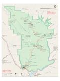
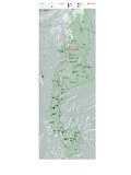
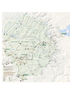
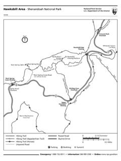
Transcription of Wawona Area Hiking Map Yosemite National Park National …
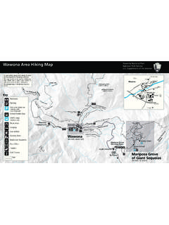
1 Wawona area Hiking Map Yosemite National Park National Park Service Department of the Interior For your safety, always carry plenty of water To Chilnualna Falls Trailhead and be prepared for changing conditions. Trail to and The Redwoods in Yosemite Alder Creek This map should not be used for Wilderness Alder Creek Trailhead trips. Please visit a park visitor center or Campground wilderness center for more information. Wawona Reservation Alder Fall Office All overnight stays in Wilderness require a ree k Chilnualna Falls d Stable rC oa Pioneer Yosemite permit. Alde 6,200 ft / 1,890 m aF. al ls R. History Center aln nu ge L. oop C hil Brid ging win To S. Wawona Dome Covered Bridge For est D rive To Yosem 6,899 ft / 2,103 m V. i te iv er Wawona Visitor Center all dR at Hill's Studio Key South Fork Merce Trail to ey Mariposa Store Big Trees Lodge Grove Gift Shop (6 miles).
2 To Yo sem Post Office Restroom ite Va lley Mo Golf Shop s qu Wa won to A. a Road (Hwy. 41). ito Parking Cre ek To South Entrance & Mariposa Grove ld e Swing i m ng Brid rC. ek ge L. Parking for vehicles dis- re re km r oop rC oun Meadow Loop Trail ek playing a valid l de d dt ri p to A oa disabled placard l sR. The Redwoods in Yosemite Fal lna (cabin rentals). Grove Shuttle Stop ilnua i ve Ald Dr er st Ch e Cr F or ee YARTS Stop k Trai ay l ne w 6 km o (Summer only) .6 km one wa rove 6 mi / 9. i/9. y osa G. 6m Marip Picnic area Wawona Wawona Visitor Campground Pioneer Yosemite Center at Hills Studio Road History Center a Lodging Wawon Wawona Meadow 4,012 ft / 1,223 m Gas Station l na W awona M eadow io Wawona Grocery Store Lo o t st a 6 km round 3.
3 5 mi/5. p re a N. trip Fo ierr Books and Souvenirs See inset, above right Grizzly Giant S. Mariposa Grove Post Office Welcome Plaza No rth Grove Arrival Stables area South Entrance Golf Course 41. To Fresno Mariposa Grove Trail of Giant Sequoias See inset, on reverse Wawona area Hiking Map Yosemite National Park National Park Service Department of the Interior Easy Strenuous Wawona Meadow Loop Begin at the Big Trees Lodge Chilnualna Falls Begin at Chilnualna Falls Trailhead parking area located two miles up Chilnualna Falls Road miles ( km) round Walk on the paved road across the Wawona Golf Course. Once across miles (13 km) round trip The trail leads from the parking area across the road and along Chilnualna Creek for 1/2 mile (.)
4 8 km). A series of trip the golf course, take a left at the sign-posted trailhead. The trail is an 5 to 6 hours (2,400 ft / switchbacks lead away from the creek into the open forest. The falls are comprised of five large cascades sliding to 2 hours unpaved fire road which loops around the meadow and returns to 732 m elevation gain) through and over rock formations above the Wawona Basin water here is fullest in spring and early summer. the Wawona Road. A relaxing and scenic stroll, this trail offers views Carry lots of drinking water in the summer, when temperatures can be extreme. across Wawona Basin and opportunities to see wildlife and wildflow- ers. Horses, bikes, and leashed pets are allowed on the trail. Mariposa Grove Trail to Begin at Mariposa Grove Arrival area Wawona Point This wide and relatively smooth trail follows a route that people have used to access the grove for generations.
5 Big Trees Loop (easy) Begin at Mariposa Grove Arrival area miles ( km) round trip See famous sequoias such as the Bachelor and Three Graces, the Faithful Couple, and the Clothespin Tree along mile ( km) round trip Winding through a forest with many giant sequoias, this trail features 3 to 5 hours this somewhat strenuous route to the upper reaches of the grove. Continue to historic Wawona Point, an over- 30 to 45 minutes the Fallen Monarch and interpretive panels on the life and ecology of 1,200 feet (366 m) elevation gain look with panoramic views. wheelchair accessible giant sequoias. This loop is relatively flat and is wheelchair accessible. Guardians Loop Trail Begin at Mariposa Grove Arrival area Grizzly Giant Loop Trail Begin at Mariposa Grove Arrival area .
6 Miles ( km) From the tranquil upper portion of the grove, a ( km) loop takes hikers past many unique features miles ( km) round Hike past notable trees such as the Bachelor and Three Graces, the 4-6 hours such as the fallen Wawona Tunnel Tree, the Telescope Tree, and the Mariposa Grove Cabin. trip Grizzly Giant, and the California Tunnel Tree. Visitors with a valid dis- 1,000 feet (300 m). to 2 hours aboled placard can drive as far as the Grizzly Giant parking and enjoy 500 feet (150 m) elevation the grove via a section of trail that is wheelchair accessible. Wawona POINT. Mariposa Grove area ELEV. 6,800 ft. (2,073 m). gain Map not to scale mi M ariposa Grove Trail ( km ). Moderate il ). m ra k .17. rT. i (1. 5m ete 3m i ( km). Grove Shuttle Stop rim Key Pe Swinging Bridge Loop Begin at Wawona Store / Pioneer Yosemite History Center parking Mariposa Grove mi ( km).
7 Tra il m km). i (0. mi ( .72. i (0 )..16. km) .4 km 5m miles ( km) round area / or at the end of Forest Drive mi (0. Restrooms k m ). Mariposa m 6 km). i ( Tree km ). mi trip The paved road, Forest Drive, leads 2 miles ( km) upstream from ( km). mi ( TO SIERRA. mi ( km). Accessible Trail Columbia Tree Mariposa Grove Cabin National . ELEV. 6,400 ft. (1,951 m). Picnic area FOREST. 2 to 3 hours the Pioneer Yosemite History Center to the Seventh Day Adventist TO Wawona . 5 mi (8 km). mi ( km). mi ian 1 mile round trip from end Camp. At the camp, bear to the left onto the dirt road and continue Secondary Trail s Lo (0. 59. m op ). k mi Parking ( 0. 6k m Trail mi (0. mi 5m ) 36. ail 74. 1/2 mile to the Swinging Bridge. Cross the bridge and bear left onto 0.)
8 3. (0. i (0.. km .8 k r Tr 6m km m). of Forest Drive ) i (0. )..58 k m Horses Allowed e te ). il Pe r i m Tra Per ter ( km). 30 minutes the trail which becomes a dirt road and then Chilnualna Falls Road. Parking for vehicles m) Perim e im 2k mi ( 7. ete mi Telescope Clothespin This road will return to the Pioneer Yosemite History Center at the displaying a valid Tree r Tra Tree il Wawona Stable. Cross the covered bridge to return to the parking disability placard mi ( k Faithful m). Couple area . Most of this trail is along roads. ALTERNATIVE: Drive the TO Wawona , GLACIER POINT ). mi ( k m). two miles to the end of Forest Drive and hike 1/2 mile one-way to k m AND Yosemite VALLEY LIMITED ACCESS: Road open ONLY to private vehicles which are 48.
9 (0. displaying a valid disabled placard when the shuttle is running. mi M. Mariposa Grove Road ipo ar Swinging Bridge. sa Gr mi ( 6k ove Washburn Trail m). Tra * i l mi (1. 2. 2m km i (3 ).. Gr i zzly Giant L. 2k o m). MARIPOSA GROVE. op SOUTH. Strenuous WELCOME PLAZA a il Tr m). ENTRANCE..32 k ELEV. 5,100 ft. (1,554 m). California mi (0. STATION mi Peri0m ( km). Bachelor Tunnel Tree .28 m & Three i (0. 4 km). ESSIBLE PARKING. eter46 km). ACC Graces i (0. m) TO..03 k Alder Creek Begin at Alder Creek Trailhead parking area ; located .4 miles up AD Trail 25 m i (1. RO . 8 km) i (0. 4m m 0. 0..6. 41. 8 miles ( km) round Chilnualna Falls Road GROVE. ARRIVAL. opTrai .21. km ). Grizzly Giant Lo ELEV. 5,900 ft. (1,798 m). l trip to Alder Creek.
10 6 hours i (0. The trail leads from the parking area across the road and heads uphill area m s k m). ree Trailhead i (0. 4. LIMITED ACCESS: Road open ONLY to private Fallen m TO SIERRA. ig T. (2,500 ft / 762 m elevation ) National . north through an open pine forest with abundant manzanita growing vehicles which are displaying a valid disabled ELEV. 5,600 ft. 24. km Monarch i (0. B. (1,707 m) FOREST. placard when the shuttle is running. m gain) on drier slopes. The trail provides access to Alder Fall, a little-visited, PICNIC area . Parking is allowed only when shuttle service is not available 100-foot cascade. Carry lots of drinking water in summer, when Wash bu rn Trail*. temperatures can be extreme. ALTERNATE ROUTE: Begin at Mosquito TO FISH CAMP.)
