Transcription of White Pocket Brochure - BLM
1 White Pocket Vermilion Cliffs National Monument NATIONA L CONSERVATION LANDS Backcountry Warning Visitors entering Vermilion Cliffs National Monument do so at their own risk. There are no marked trails, no drinking water sources, and only occasional contact with other visi tors and BLM employees. Rescue may take hours or even days. You are responsible for your own safety. Check weather, hiking, and road conditions before you set out. Be sure to carry extra water, food, and a first aid kit in case of an emergency. Bring a map and compass or GPS, and know how to use them. Tell a responsible person where you are going, when you plan to be back, and who to call if you are overdue.
2 Cell phone service in the Monument is unreliable. It is always worth attempting 911 in an emergency, but there is no guarantee. Minimize Impacts The remarkable formations of White Pocket are made of fragile sandstone. Use care when moving around the delicate formations. Leave it as you found it. Pack out all trash, including food scraps and toilet paper. Avoid stepping in or touching any pools to protect rare desert plants and animals. leave no traceCE N TER FOil OUTDOOR tf HICS Backcountry Camping The popularity of campsi tes adjacent to White Pocket is causing impacts in the form of exposed human waste and toilet paper, excessive campfire rings, and vegetation damage.
3 Please do your part to keep these areas clean and natural. Use existing campsites, and keep campsites small. Avoid places where impacts are just beginning. Bury human waste 6" deep, and well away from the campsite. Pack out all your trash, including food scraps and toilet paper. To minimize impact, do not damage trees or collect firewood. Important Phone Numbers Emergency Number 911 (to report a medical emergency or wildfire) For non-emergency situations please contact: Coconino County Sheriff Flagstaff, AZ (800) 338-7888 Kane County Sheriff Kanab, UT (877) 644-2349 Glen canyon NPS Dispatch Page, AZ or (800) 582-4351 (928) 608-6300 BLM GSENM Visitor Center Kanab, UT (435) 644-1300 BLM AZ Strip Field Office St.
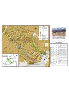
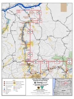
4 George, UT (435) 688-3200 BLM Kanab Field Office Kanab, UT (435) 644-1200 5 10 20 Miles Kilometers 0 5 10 20 s Grand Staircase - Escalante National Monument ,__108~9 f== Big Water, UT Contact .._ Glen canyon Station N RA House Rock Valley Road (BLM 1065) I J Vermilion Cliffs Kaibab ~r National Monument National Forast 89 !Jacob Lake, AZ Navajo Reservation White Pocket is a colorful sandstone feature located on the rugged Paria Plateau, deep within the remote Vermilion Cliffs National Monument. Please find detailed driving instructions and a map of suggested routes on the opposite page. Gett ing to White Pocket White Pocket is accessed from the House Rock Valley Road (BLM 1065).
5 To get to House Rock Valley Road from Kanab, UT, take Hi ghway 89 east for 38 miles. From Page, AZ, take Highway 89 west for 36 miles. The south end of House Rock Valley Road intersects Highway 89A miles east of Jacob Lake, AZ . The BLM 1017 turn-off to White Pocket is located just opposite an old livestock corral, miles south of Hwy 89 or miles north of Hwy 89A on BLM 1065. Take BLM 1017 east mi les to the Pine Tree Pocket Ranch, then proceed north on 1087 and 1086 to the White Pocket parking area. Leave all gates as you find them. Road Conditi ons: CAUTION A high-clearance four-wheel-drive vehicle is required to reach White Pocket . All four -wheel-drive routes, even those suggested by BLM, are used at your own risk.
6 Four-wheel-drive routes marked as "Most Difficult" are substantially rougher or have long stretches of very deep sand. If you are unsure of your vehicle's capabilities or simply don't want to assume the risk, BLM recommends hiring an authorized guide. Information on permitted guides may be found at BLM visitors centers or on our website. TRAVEL ADVISORY Deep sand on BLM 1079 increases travel risks. Westbound travel is slightly easier, and is the advised direction when using this route. ,, ,, CAUTION Most roads are deep sand, slick clay, or uneven rock. Roads are subject to flooding and conditions change often. Please inquire at BLM offices for the most current information.
7 I Co,:0te _Buttes South'\_ (~enn1t Requ1r~ ~ Deep Sand Travel Not Recommended see travel advisory mi/es , Paw Hole Access Point ( km) , Poverty f Flat Ranch " I !', I , ,-------------------JI I I ~ ' f ~ "" , ~ ~-' I ~ Co I I <v ":> I ll ~ I "I Paria Plateau I I I ' I I \ .. , , , I en (1) ,_,_ .. , .. 0 LL rn C 0 rn z .0 rn .0 Q) II) ::, 0 :r , 1017 ', Corrale, 1 -, 1080 _, , , \ ,-" , I .. ~--,_.,, , I I \ I ' I roro, ~ ,-.'-S , -~'<, \\ I~'?~ b,. "+(:-I 1<t:> I ' I ,I I Corra l 3. 1 miles ( ) , ~--~ -; - 7o7,> ~ 7 '----'~,9-?)~ +, 0 ,s, ~ , I ~---l1~07~9--,,,,,.,,,,_,~ , '\, ~ -\ \ ', \ ' ' '-\ " \ '"a ' <9$ ', ' \I I I I I ,, I , I Pine Tree ', Pocket ', Ranch , """--I I I Cottonwood Cove White Pocket g t.
8 :r I , Acfess Point 00 1 o, (4x4 ONLY) I \ ,, .. 0 0 ~ Corral I I ,, "' .. I \ ;.,,, ' ' \ Corral ,_ I - , _ !_324 " , .. ,~ ' ~, .. , _, tS',, ., "-, 1 N I \ I., 2 8 miles I \ ~I ~ ( krn) , I I ~ , /0 ~ I \ --''\- ,~ Route to White Pocket Maintained Dirt/Gravel Road ..,..~ ~ . Unma intained 4x4 O NLY Road Other Routes* U nm aintained Sand/Cla y Road 4x4 O N LY Routes Most Difficu lt 4x4 Route s Land Ownership SLM -SLM Wilderness State U S Forest Service ' Minor r outes and routes not relat ed t o White Pocket may not be depicted
