Example: marketing
www.uky.edu
National Mapping Program Topographic Map Symbols National Large Scale Series (First Map series and quadrangles Each map in a U. S. Geological Survey series conforms to
Tags:
Information
Domain:
Source:
Link to this page:
Documents from same domain

Post-Graduate Nursing Certificate Sample Plan of …
www.uky.eduPost-Graduate Nursing Certificate Sample Plan of Study Pediatric Nurse Practitioner – Primary Care Pre/ Co-requisites Course Credit Hours Didactic/ Clinical
Introduction and Theoretical Framework
www.uky.edu1 THE ELEMENTS OF A PROPOSAL Frank Pajares Emory University I. Introduction and Theoretical Framework A. “The introduction is the part of the paper that provides readers with the background
Knowledge Management and Organizational …
www.uky.eduKnowledge Management and Organizational Learning 7 Memory Sharing Utilization Transfer Refinement − Explication − Encoding − Culling − Cleaning
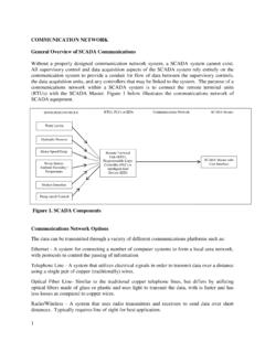
COMMUNICATION NETWORK General Overview …
www.uky.eduCOMMUNICATION NETWORK General Overview of SCADA ... construction of hardwire communication networks are not ... may necessitate the use of wireless communications ...

Teacher Efficacy: Its Meaning and Measure
www.uky.edu2 Teacher Efficacy: Its Meaning and Measure Megan Tschannen-Moran, Anita Woolfolk Hoy, and Wayne K. Hoy The theoretical and empirical underpinnings of teacher efficacy are examined to bring coherence
FOREST SERVICE HANDBOOK WASHINGTON FSH …
www.uky.edutimber cruising handbook 6 united states department of agriculture forest service timber cruising handbook contents zero code chapter 10 principles of measuring trees

Information Technology as an Enabler of …
www.uky.eduInformation Technology as an Enabler of Knowledge Management 113 73 74 75 76 77 78 79 80 81 82 83 84 85 86 87 88 89 90 91 92 93 …
Health Promotion by Social Cognitive Means
www.uky.edu10.1177/1090198104263660Health Education & BehaviorBandura / Health PromotionARTICLE(April 2004)312April Health Promotion by Social Cognitive Means Albert Bandura, PhD This article examines health promotionand disease preventionfromthe perspective of social cognitive the-
Training Manual for Right-of-Way Vegetation …
www.uky.edu3 alternative management methods, such as cropping and grazing, as well as chemical weed and brush control. Good planning and execution can result in:
HOW TO WRITE A RESEARCH ABSTRACT - …
www.uky.eduHOW TO WRITE A RESEARCH ABSTRACT Research abstracts are used throughout the research community to provide a concise description about a research project.
Related documents
WAC 332-130-112 (Proposed) Topographic map …
www.lsaw.orgPREPROPOSAL STATEMENT OF INQUIRY CR-101 (June 2004) (Implements RCW 34.05.310) Do NOT use for expedited rule making Agency: Department of Natural Resources Subject of possible rule making: Topographic Map Requirements Statutes authorizing the agency to adopt rules on this subject: RCW 58.24.040(1) Reasons why rules on this subject may be needed and what they might accomplish: Topographic ...
Reading Topographic Maps - Indiana University …
www.indiana.eduReading Topographic Maps Adapted from Guide by Boris Vasilev, Paradise Valley Community College, Phoenix, Arizona Quadrangle Name..... 1!
ws delin 2009 - WVCA - Home
www.wvca.usIntroduction This presentation explains and illustrates how to identify and draw watershed boundaries on a topographic map. The process is explained step by step in the next 16 pages.

Topographic Position and Landforms Analysis The Nature ...
www.jennessent.com0 5 10 15 20 kms Topographic Position and Landforms Analysis Andrew D. Weiss, The Nature Conservancy Study Area Basic Algorithm Slope Position Landforms Watershed Metrics

Sipsey Wilderness Trails
www.sipseywilderness.org202 2 1 1 2 9 9 9 1 9 6 9 4 4 4 6 87°29'4"w 87°28'35"w 87°28'6"w 87°27'37"w 87°27'8"w 87°26'40"w 87°26'11"w 87°25'42"w 34°17'2"n 34°17'31"n 34°18'0"n