Transcription of Zone 5 Onward Travel Information - National Rail …
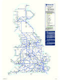
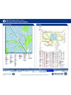
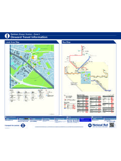
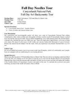
1 Onward Travel InformationiSidcup Station Zone 5 Halfway StreetOld Farm Road WestHalfway StreetHollies AvenueWillersley AvenueAnnandale RoadWillersley AvenueOaklands AvenueWillersley AvenueMarlborough Park AvenueBlackfen The OvalWellington Avenue Blackfen RoadWellingPlumstead CommonWoolwich Town Centrefor Woolwich ArsenalHalfway StreetCorbylands RoadHalfway StreetDays LaneHalfway StreetRestons CrescentAvery HillUniversity ofGreenwichMain RoadChristchurchRoadMain RoadSydney RoadMain RoadNorthcoteRoadFootscray RoadThaxted RoadFootscray RoadCounty GateMain RoadMarechalNiel ParadeLonglands RoadSidcupQueen Mary s Hospital(Main Entrance)Queen Mary s HospitalB BlockQueen Mary sHospitalA & EPerry StreetLeas GreenPerry StreetBeaverwood RoadPerry StreetAshfield LaneChislehurstWar MemorialChislehurstfor Chislehurst CavesChislehurstHigh StreetChislehurstGordon ArmsEdgeburyPrimary SchoolNew ElthamFivewaysNew ElthamFootscray RoadGreen LaneElthamSouthend CrescentElthamChurchBickleyBickley Park Road/Southborough RoadWidmore GreenBromley NorthElthamElthamGreenLee GreenLewishamMiddle Park AvenueNewmarket GreenWesthorne AvenueSidcup RoadSt Mildred s RoadCatfordLewisham Town HallCatford andCatford BridgeEltham Well HallRochester WayBlackheath Sun-in-the-Sands RoundaboutWestcombe ParkEast Greenwich LibraryGreenwich Cutty Sarkfor National Maritime MuseumSidcup HillKnoll RoadSidcup HillMiddleton AvenueCray Road Mayfield VillasCrittall s CornerFoots Cray Te s c oFive ArchesBusiness EstateMaidstoneRoadPalm
2 AvenueRuxleyCornerNorth Cray RoadBarton RoadNorth Cray RoadEllenborough RoadNorth CrayChurchSt Paul s CrayMidfield WayChipperfield RoadSt Mary CrayCray Avenue Nugent Retail ParkOrpington Carlton ParadeOrpington War MemorialOrpington Hospital GroundsGreen Street Green High StreetOrpingtonMaidstone RoadGlebe CottagesBirchwoodCornerSwanleyNorthviewS wanleyBeechenleaLaneHurst RoadHurstmere SchoolFaraday AvenueBirchwood AvenueFaraday AvenueMelville RoadFoots Cray LaneCanterbury AvenueLongmead DriveOnslow DriveFoots Cray LaneHurst RoadHurst RoadEynsfordCrescentPenhill RoadBlendonDanson UnderpassDanson ParkSt John sRoadTheDriveBexley LaneCleeve Park SchoolKimberley DriveMaylandsDriveRoyalRoadAlbany ParkLongmead DriveHurst RoadCrofton AvenueHurst RoadCarisbrooke AvenueHurst RoadHurst SpringsBexleyBexley LibraryGravel HillBexleyheath Bus GarageBexleyheath Shopping CentreThamesmead Town CentreThamesmead CrosswayThamesmead Boiler HouseAbbey WoodBelvedereErith Town CentreBridgenThe AnchorTownley RoadCrayford Town HallChastilian RoadBluewater Shopping CentreShepherd s LaneDartfordHorns CrossCrook LogLeisure CentreFaraday AvenueWren RoadSevenoaks WayKemnal Technology CollegeBlackheath Royal StandardNorth Cray RoadVicarage RoadNorth Cray RoadMount Mascal FarmCrayfordBexleyWar MemorialSwanleyHigh StreetSandhurst RoadVerdant LaneEast Greenwich Vanbrugh HillMaze HillGreen LaneWilliam Barefoot DriveSt Mary CrayStation ApproachBromley Town CentreElthamHigh StreetSevenoaks WayBroomwood RoadOrpington High Street/Walnuts CentreNew Cross GateLansdownRoadGreenhitheNew Cross GateSainsbury sCray RoadFoots Cray High StreetFoots CrayHigh StreetRectory LaneMaidstone RoadRuxley NurseryBarnehurstNorthumberland HeathHail & RidesectionHail & RidesectionHail & Ride sectionHail &
3 Ridesection51R11286229269233160286R1151B 14233229492269B14 CATFORDGREENWICHELTHAMCHISLEHURSTBROMLEY WELLINGWOOLWICHORPINGTONSWANLEYBEXLEYTHA MESMEADERITHBLACKFENALBANYPARKFOOTSCRAYN EWELTHAMThe yellow tinted area includes everybus stop up to one-and-a-half milesfrom Sidcup. Main stops are shownin the white area ROADOLD FARM ROADMANOR ROADMAIN ROADGRANVILLE ROADHADLOW H S TR E ETELM ROADCHURCHGRASSINGTON ROADROADSTATION ROADLANSDOWN ROADCHRISTCHURCH ROADST JOHN S AVENUEJUBILEE WAYTHE GREENH&R3 EFBALHNMTPRSVUYZH&R2H&R1H&R4 WGCKJDXS idcup321321 Route finderDay buses including 24-hour servicesDestinationBus routesBus stopsDestinationBus routesBus stopsDestinationBus routesBus stopsDestinationBus routesBus stops51160229233269286321492B14R11 Destination finderuConnections with London OvergroundRConnections with National rail Connections with Docklands Light Railway Connections with river boatsWMondays to Saturdays, also Sunday shopping hoursKeySIDCUP DR (BEX) (F) Transport for LondonInformation correct from February 2015 Red discs show the bus stop you need for your chosen busservice.
4 The disc Aappears on the top of the bus stop in thestreet (see map of town centre in centre of diagram).Routes 233 and B14 operate as hail and ride on thesections of roads marked on the map. Buses stop at any safe point along the indicate clearly to the driver when you wish toboard or alight. 123456 AOrpington G M T YWoolwich A L N V ZCatford F H M S WSidcup C G M S WQueen Mary s HospitalThamesmead B L N R XEltham L N V Z Swanley G M T Y Bexleyheath J L N R XBromley H K M S WGreenwich A L N R XSidcup G M S WQueen Mary s HospitalFoots Cray P T YNew Cross Gate U ZBluewater F H M T YBexleyheath W T X Orpington W S U W Green Street Green T X YSidcup S U W ZQueen Mary s Hospital Bus routeTowardsBus stopsAAbbey Wood R229 B L N R XAlbany Park R Longmead DriveB14 W T X Avery Hill University of Greenwich286 A L N R XBBarnehurst R229 B L N R XBelvedere R229 B L N R XBexley R229 B L N R XBexley Library229 B L N R X492 F H M T YBexley War Memorial269 J L N R XBexleyheath Bus Garage229 B L N R XBexleyheath Shopping Centre229 B L N R X269 J L N R X492 F H M T YB14 W T X Bexley Lane
5 Cleeve Park SchoolB14 W T X BickleyR269 H K M S WBirchwood Corner233 G M T Y Blackfen51 A L N V ZBlackheath Royal Standard286 A L N R Xand Sun-in-the-Sands RoundaboutBlendon Danson UnderpassB14 W T X Bluewater Shopping Centre492 F H M T YBridgen The Anchor269 J L N R XBromley Town Centre and269 H K M S WBromley NorthR PPenhill RoadB14 W T X Perry Street Ashfield Lane,160 D H M S WBeaverwood Road and Leas Green269 H K M S WPlumstead Common51 A L N V ZQQueen Mary s HospitalB14 W S U W A & E and B BlockQueen Mary s Hospital 160 F H M S W(Main Entrance)229 C G M S W269 H K M S W286 G M S WB14 W S U W R11 S T W ZRRochester Way286 A L N R XRoyal RoadB14 W T X Ruxley Corner233 G M T Y 492 F H M T YSSt John s RoadB14 W T X St Mary CrayRB14 W S U W R11 T X YSt Mary Cray StationApproach51 G M T YSt Mildred s Road160 F H M S WSt Paul s Cray Midfield WayB14 W S U W R11 T X YSandhurst Road Verdant Lane160 F H M S WSevenoaks Way 51 G M T YKemnal Technology CentreB14 W S U W R11 T X YSevenoaks Way Broomwood Road51 G M T YSidcup Hill51 G M T Y233 G M T Y 321 P T Y492 F H M T YR11 T X YSwanley233 G M T Y TThamesmead229 B L N R XTownley Road269 J L N R XWWellingR51 A L N V ZWellington AvenueBlackfen Road51 A L N V ZWestcombe ParkR286 A L N R XWesthorne Avenue Sidcup Road160 F H M S WWidmore Green269 H K M S WWillersley Avenue51 A L N V
6 ZWoolwich Town Centre51 A L N V Zfor Woolwich Arsenal R CCatford Lewisham Town Hall160 F H M S WCatfordRandCatford BridgeR160 F H M S WChastilian Road492 F H M T YChipperfield RoadB14 W S U W R11 X YChislehurst R269 H K M S WChislehurst 160 F H M S WGordon Arms and High StreetChislehurst War Memorial160 F H M S W269 H K M S WCrayford Rand Town Hall492 F H M T YCray AvenueNugent Retail Park51 G M T YB14 W S U W R11 T X YCray Road51 G M T Y321 P T YR11 T X YCrittall s Corner51 G M T Y321 P T YR11 T X YCrook Log Leisure Centre B14 W T X DDanson ParkB14 W T X DartfordR492 F H M T YDrive, TheB14 W T X EEast Greenwich 286 A L N R XEdgebury Primary School160 F H M S WElthamR233 L N V Z 286 A L N R XEltham Church and High Street160 F H M S W233 L N V Z 286 A L N R X321 U ZEltham Southend Crescent160 F H M S W233 L N V Z 321 U ZEltham Well Hall286 A L N R XEltham Green160 F H M S W321 U ZErith Town Centre229 B L N R XFFaraday Avenue 269 J L N R XFive Arches Business Estate233 G M T Y 492 F H M T YFoots Cray High Street51 G M T Y233 G M T Y 321 P T Y492 F H M T YR11 T X YFoots Cray Tesco321 P T YR11 T X YFoots Cray Lane 269 J L N R XCanterbury Avenue and Hurst RoadB14 W T X Footscray Road 233 L N V Z County Gate and Thaxted Road321 U Z Footscray Road Green Lane160 F H M S W233 L N V Z 321 U ZGGravel Hill229 B L N R X492 F H M T YGreenhithe492 F H M T YGreen Lane William
7 Barefoot Drive160 F H M S WGreen Street GreenR11 T X YGreenwich Cutty Sark 286 A L N R XHHalfway Street Corbylands Road,286 A L N R XDays Lane and Restons CrescentHalfway Street Hollies Avenue51 A L N V Zand Old Farm Road West286 A L N R XHorns Cross492 F H M T YHurst Road Carisbrooke Avenue,229 B L N R XCrofton Avenue, Eynsford Crescent269 J L N R Xand Hurst SpringsHurst Road Hurstmere School229 B L N R XKKimberley DriveB14 W T X LLansdown RoadB14 W T X Lee Green321 U ZLewishamR 321 U ZLonglands Road233 L N V Z Longmead Drive B14 W T X MMaidstone Road Glebe Cottages233 G M T Y Maidstone Road Palm Avenue233 G M T Y 492 F H M T YMain Road Christchurch Road,321 U ZNorthcote Road and Sydney RoadMain Road Marechal Niel Parade233 L N V Z 321 U ZMaylands DriveB14 W T X Maze HillR286 A L N R XMiddle Park Avenue160 F H M S WNNew Cross Sainsbury s321 U ZNew Cross Gateu R321 U ZNew ElthamR160 F H M S W233 L N V Z 321 U ZNew Eltham Fiveways 160 F H M S WNorth Cray Church492 F H M T YNorth Cray Road 492 F H M T YNorthumberland Heath229 B L N R XOOrpingtonR51 G M T YB14 W S U W Orpington Carlton Parade, 51 G M T YHigh Street/Walnuts Centre B14 W S U W and War MemorialR11 T X YOrpington Hospital GroundsR11 T X Y AA2 Alder RoadB2 Alma RoadA2 Appledore CrescentC2 Ash CloseB2 Aston CloseA2 Austral CloseBB3 Back RoadB2 Becks RoadB3 Belton RoadC1 Birchwood AvenueB2 Birkbeck RoadB3 Black Horse RoadB1 Burnt Oak LaneA1 Bursdon CloseCB3 Carlton RoadC3 Charles CloseB1 Chestnut CloseC2 Chevenings.
8 TheA2 Christchurch RoadC3 Church AvenueB3 Church RoadA2 Chyngton CloseB2 Clarence CrescentB2 Clarence RoadC1 Cleeve Park GardensC3 Close, TheA3 Cloudesley CloseC3 Craybrooke RoadB2 Crescent RoadA3 Crescent, TheC3 Cross RoadDC2 Damon CloseC2 Denberry DriveC2 Drive, TheEB3 Elm RoadC2 Embassy CourtFC1 Faraday AvenueC2 Farwell RoadGA1 Gloucester AvenueC3 Glyn DriveB2 Grange CloseB3 Granville MewsB2 Granville RoadB3 Grassington RoadB3 Green, TheB1 Greenwood CloseB2 Gresswell CloseHB3 Hadlow RoadA1 Halfway StreetA2 Ham Shades CloseB3 Hamilton RoadA1 Harland AvenueB1 Hatherley CrescentB2 Hatherley RoadC1 Hemmings CloseB3 High StreetC2 Highview RoadA1 Hollies AvenueB1 Hurst RoadJB3 Jenner CloseB1 Jubilee WayKB1 Kingsmead CloseC3 Knoll RoadLA1 Lamorbey CloseB2 Langford PlaceC2 Lansdown RoadA2 Larkfield RoadB2 Laurel CloseC3 Lawns, TheA1 Lingey CloseA1 Longlands RoadA2 Lyminge CloseMA3 Main RoadB2 Manor RoadNB3 Nelson RoadA3 Neville CloseB3 Nisbett WalkOA1 Old Farm AvenueA1 Old Farm Road EastA1 Old Farm Road WestC3 Old Forge WayPB3 Park, TheC1 ParksideA2 Priestlands Park RoadRA2 Rangeworth PlaceC3 Rectory CloseC3 Rectory LaneC2 Rosewood CloseSC2St.
9 John s RoadB2 Sandhurst RoadC3 Sedcombe CloseC3 Selborne RoadB3 Sharman CourtB2 Shelbury CloseC3 Sidcup HillB3 Stanhope RoadB2 Stanley RoadB1 Station RoadA3 Stirling CloseA2 Studland CloseA3 Sydney RoadTC2 Tarling CloseA2 Taylors CloseUA3 Updale RoadVB2 Victoria RoadWC2 Walton RoadC3 Wren RoadYA1 York AvenueC1 Abbeyhill ParkA1 Abbotsleigh MewsC2 Adult Education College BexleyB2 Benedict House Preparatory SchoolB2 Bird CollegeB2 Bird College of DanceB2 Birkbeck Primary SchoolA3 Carlton CentreC1 Chislehurst & Sidcup Grammar SchoolA3 Christ ChurchB3 Emmanuel ChurchB1 Fold, TheB1 Glade, TheB1 Holy Trinity HallB1 Holy Trinity LamorbeyB1 Holy Trinity Lamorbey C of E Primary SchoolA1 King George s FieldC3 Kingswood HouseA3 Lawrences Community CentreA2 Longlands Recreation GroundB3 Manor House Register OfficeB1 Marlowe HouseC3 Merton Court Preparatory SchoolC1 Montrose Park ClubB3 MorrisonsB2 New Community ChurchB2 New Generation CentreA1 Old Farm ParkB3St.
10 John s SidcupA3St. Lawrence of CanterburyCatholic ChurchB3 Shah Jalal Education & Cultural CentreA3 Sidcup & Foots Cray UnitedServices ClubA3 Sidcup Baptist ChurchA3 Sidcup Fire StationB3 Sidcup GreenB3 Sidcup HouseB1 Sidcup Leisure CentreB3 Sidcup LibraryB3 Sidcup Nursing & ResidentialCentre, TheA3 Sidcup Sports ClubA2 Sidcup Working Men s Social Club& InstituteA1 Stuart HouseB3 TravelodgeC2 Waring ParkB2 West Lodge SchoolStreet finderLandmark finderKeyOyster Ticket Stop, where you can top upyour Oyster pay as you go credit andpurchase Travelcards and Bus & Tram PassesNational rail stationStation exitBus stopCar parkPublic toilet1747721101156199851201481274139167 3152011251610301643132564611086791638231 1855722421617492111233211522511810111918 1401297639126291612212420341231111941061 7366312712323141111111815182550391151892 3235443466111049146352411657242360372647 1212541144163151551186411624716147121127 1481015921991111726102636146211553411534 6482628189321157198752117211301112742634 8345044191192811338236512514112301481455 7061111130172199129 SEDCOMBE CLOSEGLYN DRIV