Example: dental hygienist
Chapter 8 County Subdivisions - Census.gov
information on similar geographic entities in Puerto Rico and the Outly-ing Areas, see Chapter 7. Background The decennial population censuses always have sought to identify county subdivisions as a primary geographic entity. The first census ( 1790) reported population counts for MCDs (towns, townships, and other
Tags:
Information
Domain:
Source:
Link to this page:
Documents from same domain
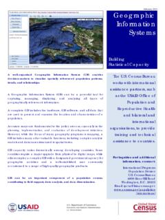
Geographic Information Systems - census.gov
www2.census.govGeographic Information Systems . Building . Statistical Capacity . The U.S. Census Bureau works with international assistance partners, such as the USAID Office of
Michigan Department of Treasury 3965 (Rev. 4/05) …
www2.census.govLocal Unit Identification FORM F-65(MI) (4-14-2005) Michigan Department of Treasury F-65(MI) 3965 (Rev. 4/05) ANNUAL LOCAL UNIT FISCAL REPORT FOR FISCAL YEARS ENDING BETWEEN
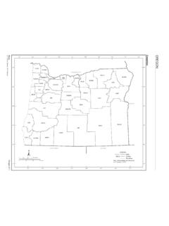
Maps - Census
www2.census.govMaps Oregon E-3 U.S. Census Bureau, 2010 Census COUNTY MAP SEC Baker 3 Benton 1 Clackamas 1 Clatsop 1 Columbia 1 Coos 6 Crook 2 …
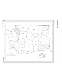
Maps - Census
www2.census.govThe county subdivision name is shown only if different than the name of the place. Section Locator. Maps Washington E-3 U.S. Census Bureau, 2010 Census COUNTY MAP SEC Adams 5 Asotin 5 Benton 5 Chelan 3 Clallam 1 Clark 6 Columbia 5 Cowlitz 6 Douglas 3 Ferry 4 Franklin 5 Garfield 5 Grant 3 Grays Harbor 1 Island 2 Jefferson 1 …
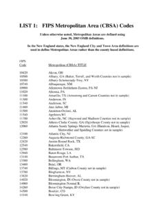
LIST 1: FIPS Metropolitan Area (CBSA) Codes
www2.census.govLIST 1: FIPS Metropolitan Area (CBSA) Codes ... the New England City and Town Area definitions are ... 11500 Anniston-Oxford, AL
Population by Region and Country: 1950-2050
www2.census.govRegion and country or area 1950 1960 1970 1980 1990 2002 2010 2025 2050 .Vietnam 25,348 31,656 42,577 53,661 66,637 80,577 89,223 104,436 116,813 LATIN AMERICA AND THE

Fun Facts: Father’s Day–June 17 - census.gov
www2.census.govFun Facts: Father’s Day ... Sources: Data on this page come from the U.S. Census Bureau’s 2014 Survey of Income and Program Participation, 2017 Current Population Survey, and 2016 County Business Patterns. Fathers by the Numbers 72 million* The estimated number of fathers across the nation.

Fun Facts: 2017 Holiday Season - Census
www2.census.govCENSUS.GOV/SCHOOLS Fun Facts: The 2017 Holiday Season Holiday Celebrations This festive season, or simply the holidays, is a time for gathering and celebrating with family
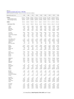
2010 Census - Census Tract Reference Map
www2.census.govCanoe Creek State Park Blue Knob State Park State Gamelands No 41 Warriors Path State Park State Gamelands No 41 F ra n k s t o w n Hollidaysburg° B r a
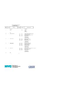
New York City Housing and Vacancy Survey 2017 Record ...
www2.census.govNew York City Housing and Vacancy Survey 2017 Record Layout Household Record -- Occupied Units 1 Record Type 1=OCCUPIED 2
Related documents

Cloud services due diligence checklist
download.microsoft.comData location List the geographic locations that data may be processed and stored, and if the cloud service customer can specify location requests. Data examination Describe how the cloud service provider examines cloud service customer data. Data Management Page Microsoft Cloud Services Due Diligence Checklist Page 3 of 4

Introduction to GIS - MIT OpenCourseWare
ocw.mit.edugeographic objects with a variety of shapes and layer those shapes on top of one another to create maps and perform analysis. •Polygons . 5. With GIS software, you can digitally represent geographic objects with a ... have a known location on the earth.

NATIONAL GEOGRAPHIC TRAVEL MEDIA INFORMATION KIT …
www.nationalgeographic.comNational Geographic Traveler attracts the most readers— 9.7 million*—driven to explore ... makes it the premiere location to inspire millions with the means and the mindset to travel.
SUPREME COURT OF THE UNITED STATES
www.supremecourt.govJun 19, 2018 · record known as cell-site location information (CSLI). The precision of this information depends on the size of the geographic area covered by the cell site. The greater the concentration of cell sites, the smaller the coverage area. As data usage from cell phones has increased, wireless carriers have installed more cell sites to handle the ...

Section 1: Asset Mapping - University of California, Los ...
healthpolicy.ucla.edumap. In this case it is fine to approximate the location. • Remember that the map should not only be visually appealing but also highlight something. For example, show gaps in services, areas where services are needed, or where there exists a cluster of services in only one geographic area. UCLA Center for Health Policy Research

iCloud Private Relay Overview
www.apple.comgeographic area best represents the user’s original IP address. It then sends this information back to the user’s device in the form of a geohash (truncated to four characters, representing roughly an 800 km 2 area). If the user has selected “Maintain general location,” the user’s device will …

Increasing Returns and Economic Geography Paul Krugman
pr.princeton.eduin the region with larger demand, but the location of demand itself depends on the distribution of manufacturing. Emergence of a core-periphery pattern depends on transportation costs, economies of scale, and the share of manufacturing in national income. The study of economic geography-of the location of factors of pro- ...
Geographic Adjustment of Medicare Payments to …
www.cms.govand the physician geographic adjustment factor. Metropolitan statistical areas and statewide non-metropolitan statistical areas should serve as the basis for defining these labor markets. 2-2 : The data used to construct the hospital wage index and the physician geographic adjustment factor should come from all healthcare employers. 4-1

Band A and Band B countries and regions
london.ac.ukCountries and Regions Countries and Regions in Band A •Afghanistan •Albania •Algeria •American Samoa •Angola •Argentina •Armenia •Azerbaijan