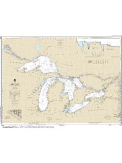
Transcription of West End of Lake Erie
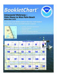
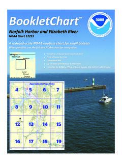
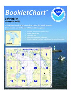
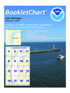
1 BookletChart west End of lake Erie NOAA Chart 14830 A reduced-scale NOAA nautical chart for small boaters When possible, use the full-size NOAA chart for navigation. Included Area 2 Published by the National Oceanic and Atmospheric Administration National Ocean Service Office of Coast Survey 888-990-NOAA What are Nautical Charts? Nautical charts are a fundamental tool of marine navigation. They show water depths, obstructions, buoys, other aids to navigation, and much more. The information is shown in a way that promotes safe and efficient navigation. Chart carriage is mandatory on the commercial ships that carry America s commerce.
2 They are also used on every Navy and Coast Guard ship, fishing and passenger vessels, and are widely carried by recreational boaters. What is a BookletChart ? This BookletChart is made to help recreational boaters locate themselves on the water. It has been reduced in scale for convenience, but otherwise contains all the information of the full-scale nautical chart. The bar scales have also been reduced, and are accurate when used to measure distances in this BookletChart. See the Note at the bottom of page 5 for the reduction in scale applied to this chart. Whenever possible, use the official, full scale NOAA nautical chart for navigation.
3 Nautical chart sales agents are listed on the Internet at This BookletChart does NOT fulfill chart carriage requirements for regulated commercial vessels under Titles 33 and 44 of the Code of Federal Regulations. Notice to Mariners Correction Status This BookletChart has been updated for chart corrections published in the Coast Guard Local Notice to Mariners, the National Geospatial Intelligence Agency Weekly Notice to Mariners, and, where applicable, the Canadian Coast Guard Notice to Mariners. Additional chart corrections have been made by NOAA in advance of their publication in a Notice to Mariners.
4 The last Notices to Mariners applied to this chart are listed in the Note at the bottom of page 7. Coast Pilot excerpts are not being corrected. For latest Coast Pilot excerpt visit the Office of Coast Survey website at (Selected Excerpts from Coast Pilot) Vermilion, about 34 miles W of Cleveland, has a harbor used mainly by fishing and recreational craft. The harbor comprises the lower 3,000 feet of the Vermilion River, and an approach channel from the lake . About mile SE of the river entrance, a lighted tank with the name VERMILION on the side is prominent. Huron Harbor is about 44 miles W of Cleveland inside the mouth of the Huron River at the city of Huron, Ohio.
5 Huron Harbor Light (41 'N., 82 'W.), 80 feet above the water, is shown from a white square pyramidal tower on the W pierhead. A fog signal is at the light. From Huron, the wooded shoreline trends NW for miles to Cedar Point (41 'N., 82 'W.), the SE entrance point to Sandusky Bay. In this stretch, deep water is about to miles off except at Cedar Point where the shallow depths widen to miles. Sandusky Harbor, serving the city of Sandusky, Ohio, is in the SE part of Sandusky Bay about 50 miles W of Cleveland. The harbor is a major shipping point for coal. Sand, gypsum, and fish are also handled.
6 The harbor is an excellent natural harbor of refuge for small craft. Sandusky Bay extends W from its entrance between Cedar Point and Bay Point for about 15 miles to Muddy Creek Bay. Sandusky River flows into the S side of Muddy Creek Bay. Small craft can navigate through Sandusky Bay, Muddy Creek Bay, and upstream in the Sandusky River for about 15 miles to the Norfolk Southern Railway Bridge at the town of Fremont, Ohio. Depths of about 5 feet can be carried through Sandusky Bay, thence 2 to 4 feet through Muddy Creek Bay, and 2 to 19 feet in the river. The channels through the bays are indefinite and not marked.
7 The entrances to Muddy Creek Bay and the Sandusky River are marked by uncharted buoys that are frequently moved to mark the best water. Marblehead Coast Guard Station is close W of Marblehead Stone Docks. A small sheltered basin at the station has depths of 8 feet decreasing to 6 feet at the edges. Between Catawba Island and Locust Point (41 'N., 83 'W.), a rounding projection 12 miles W, a broad open bight has depths less than 24 feet. The Portage River empties into the S side of the bight. A large shallow bank with depths less than 14 feet extends about miles N and NE off Locust Point.
8 A least depth of 2 feet, marked on the E side by a buoy, is about miles NE of the point, and there are scattered patches of 3 to 10 feet elsewhere. Niagara Reef, a detached shoal with a least depth of 3 feet, is miles NE of the point and is marked on the N side by a lighted buoy. Huron Harbor Dangers. An extensive area of fish net stakes is off the entrance to Huron Harbor. Huron is within the Sandusky customs port of entry. Quarantine is enforced in accordance with the regulations of the Public Health Service. (See Public Health Service, chapter 1.) Harbor Regulations.
9 A speed limit of 6 mph ( knots) is enforced in the harbor except in the outer harbor where the speed limit is 10 mph ( knots). (See 33 CFR and , chapter 2, for regulations.) Sandusky Harbor Dangers. In 1977, it was reported that the jetty extending NE from Cedar Point is partially submerged during periodic high water conditions. Caution. A submarine cable crosses the inner end of Moseley Channel; vessels are cautioned not to drag anchor in this area. Sandusky is a customs port of entry. Toledo is a customs port of entry. Quarantine is enforced in accordance with the regulations of the Public Health Service.
10 (See Public Health Service, chapter 1.) Harbor regulations. Speed in harbor. In Maumee Bay, lakeward of Maumee River Lighted Buoy 49, no vessel greater than 100 feet long shall exceed 12 mph ( knots). No person shall operate any vessel over 40 feet long in the harbor at a speed greater than 6 mph ( knots). Vessels greater than 100 feet long shall not overtake another vessel in the harbor. (See 33 CFR , chapter 2, for speed limits and regulations.) Coast Guard Rescue Coordination Center 24 hour Regional Contact for Emergencies RCC Cleveland Commander 9th CG District (216) 902-6117 Cleveland, OH G Lateral System As Seen Entering From Seaward on navigable waters except Western Rivers PORT SIDE ODD NUMBERED AIDS GREEN LIGHT ONLY FLASHING (2)