Transcription of APPENDIX A: Culvert Sizing procedures for the 100 …
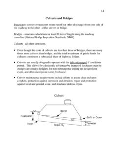
1 APPENDIX A: Culvert Sizing procedures for the 100-Year Peak FlowA. INTRODUCTION Several methods have been developed for estimating the peak flood discharge that can be expected from small ungaged, wildland watersheds. These procedures are useful for determining the size (diameter) of Culvert that should be installed in a stream crossing that is to be constructed or upgraded. Determining the proper size (diameter) Culvert requires: 1) estimating the peak dis-charge of streamflow which would occur at each stream crossing during the 100-year flood, and then 2) determining the size of Culvert which would handle that flow using the Federal Highway Administration (FHWA) Culvert capacity nomograph (FHWA, 1965).
2 A summary of selected methods, with example calculations for flood flow estimating is avail-able from the California Department of Forestry and Fire Protection (CAL FIRE) in an in-house document called Designing Watercourse Crossings for Passage of 100-year Flood Flows, Wood, and Sediment (Cafferata et al., 2004). The document covers such techniques as the Rational Method, the USGS Magnitude and Frequency Method, and the Flow Transfer-ence Method. Each method has its strengths and weaknesses, and relies on field or map measurements, published climatic data, and subjective evaluations of watershed conditions. Several of the methods require precipitation intensity data which are typically available from the National Oceanic and Atmospheric Administration (NOAA) website: , or your state s water resource or forestry departments.
3 Rainfall depth-duration frequency data are also avail-able in published map atlases online, or in good public and college libraries. Ask for assistance from the state forest professional with jurisdic-tion for your area, as foresters are routinely required to perform these calculations. A description of methodology and an example are provided for the three techniques to estimate the 100-year flood flow (Rational Method, USGS Magnitude and Frequency Method, and Flow Transference Method). It is recommended that two or three different methods be used in an area to compare and verify the results. Field experience can also be used as a check. Just remember, most of us have not been around for a 100-year flood and we naturally tend to underestimate the amount of water that is carried by streams during these extreme events.
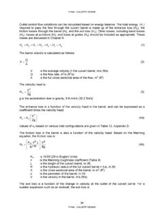
4 B. Culvert Sizing METHODS (EXAMPLES)Method 1. the RAtIoNAL Method oF eStIMAtING 100-YeAR FLood dISChARGeThe most commonly used technique for estimating 100-year flood discharges from small ungaged forested water-sheds is the Rational method is based on the equation: Q100 = CIA343 HANDBOOK FOR FOREST, RANCH AND RURAL ROADSCULVERT Sizing procedures FOR THE 100-YEAR PEAK FLOWW here: Q100 = predicted peak runoff from a 100-year runoff event (in cubic feet second) C = runoff coefficient (percent of rainfall that becomes runoff) I = uniform rate of rainfall intensity (inches/hour) A = drainage area (in acres) Assumptions:1.
5 The 100-year design storm covers the entire basin with uniform constant rainfall intensity until the design dis-charge at the crossing is achieved. 2. The design watershed charac-teristics are Overland flow. This method is less accurate or predictable as the percent impervious surface area in the watershed The runoff coefficient (C) is constant across the The 100-year storm event produces the 100-year flood : 1. Frequently used and flexible enough to take into account local conditions. 2. Easy to use if local rainfall data is available. Disadvantages: 1. Flexibility may lead to misuse, or misinterpretation of local conditions. 2. Precipitation factor I may be dif-ficult to obtain in remote areas.
6 3. Less accurate for watersheds greater than 200 acresInformation needed: A = area of watershed (acres) C = runoff coefficient from table A-1 H = elevation difference between highest point in watershed and the crossing point (feet) L = length of channel from the head of the watershed to the crossing point (miles) I = uniform rate of rainfall intensity. Obtained from precipitation fre-quency-duration data for local rain gages as shown in table A-2. TABLE A-1. Values for Rational Method runoff coefficient (C) valuesSoilsLand use or typeC valueSandy and gravelly and similar soils without impeded clay soil or those with a shallow impeding horizon; shallow over A Steps: 1. Select runoff coefficient (C) values: Several different publications give a range of C values for the rational formula, however, the values given in table A-1 by Rantz (1971) appear to be the most appropriate for the woodlands and forests around Eureka, California.
7 2. Select a rainfall intensity (I) value: In selecting an I value, two factors are considered: a) the travel time or time of concentration (Tc) for the runoff to reach the crossing, and b) the precipitation conditions for the particular watershed in question. a. Time of concentration (Tc) can be calculated using the formula: Tc = [ ] : Tc = time of concentration (in hours) L = length of channel in miles from the head of the watershed to the crossing point H = elevation difference between highest point in the watershed and the crossing point (in feet) (where the Culvert is going to be installed). (Note: if the value of Tc is calcu-lated as less than 10 minutes, studies suggest you should use a default value of 10 minutes)b.
8 Uniform rate of rainfall intensity. Once the time of concentration has been determined, then that value is used to determine which rainfall duration to use ( , if Tc = 1 hour, then use 100-year, 1 hour precipita-tion duration; if Tc = 4 hours, then use 100-year, 4-hour duration). Rainfall depth duration tables similar to table A-2 are available for precipitation stations throughout each state. For example, rainfall depth duration fre-quency data can be obtained from the California Department of Water Resources on-line at Contact your state s water resources department (or its equivalent) to obtain rainfall depth duration frequency data for your A-2. example of Rainfall depth duration Frequency data for eureka, California National Weather Service Station (NWS)Design storm (Return Period)Maximum precipitation for indicated rainfall duration5 Min10 Min15 Min30 Min1 hr2 hr3 hr6 hr12 hr24 hrC-YrRP FOR FOREST, RANCH AND RURAL ROADSCULVERT Sizing procedures FOR THE 100-YEAR PEAK FLOW example: Rational Method used to calculate 100-year design storm 1.
9 Area of example stream crossing watershed (A) = 100 Runoff coefficient (C) = (loam woodland soil, from table A-1)3. Calculate the time of concentration (Tc) Tc = [ ] , L = mi., H = 200 ft. Tc = [ ( )3200] inchesAccording to table A-2, a value of inches corresponds to the 15-minute intensity of a 100-year return period storm event. 4. Calculate the rainfall intensity (I) I =( in15 min) (x in60 min) = in/hr5. Calculate Q100Q100 = CIA Q100 = ( ) ( ) (100) = cubic feet per second (cfs) Method 2. the USGS MAGNItUde ANd FReQUeNCY Method FoR eStIMAtING 100-YeAR FLood dISChARGe The USGS Magnitude and Frequency Method is based on a set empirical equations derived for six regions in the state of California for the 2-, 5-, 10-, 25-, 50-, and 100-year design flood flows.
10 These equations were developed from the precipitation and runoff data collected from more than 700 stream gaging stations in California (USGS, 2012). For the purposes of this handbook, only the set of equations for the 100-year design flood flow are shown below: North Coast Q100 = Q100 = Region Q100 = 1, Coast Q100 = Coast Q100 = Q100 = : Q100 = predicted peak runoff from a 100-year storm (cubic feet second) A = drainage area (square miles) H = Mean basin elevation (feet) P = mean annual precipi-tation (inches/year) Assumptions:1. The 100-year design storm uniformly covers large geographic areas. 2. The design watershed charac-teristics are The 100-year storm event produces the 100-year flood : 1.