Transcription of Clifty Wilderness
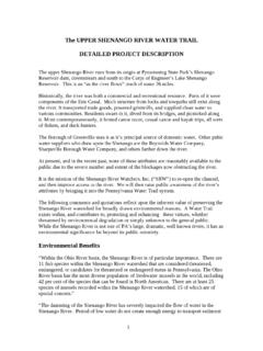
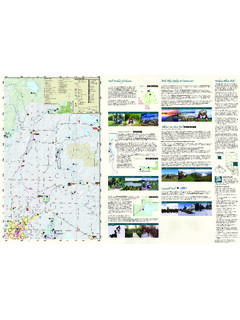
1 Clifty WildernessClosed to all motorized vehiclesand mountain RIVERG ladieCultural-EnvironmentalLearning CenterChimneyTop RockNadaTunnelTarrRidgePicnicAreaRavensR ockHaystackRockCourthouseRockGray'sArchD . BoonHutHemlockLodgeNatural BridgeState ResortParkMiddle (Exit33)ToStantonNadaDoubleArchPrincessA rchCliftyWildernessGate77777777777777 Footbridge1111151515113939164 RockBridgeSwift CampCreek TrailWildcatTrailAngelWindowsSheltoweeTr aceBisonWayTrailTower RockTrailSkyBridgeWhistlingArchRough TrailSwiftCampCreekTrailKoomerRidgeTrail WhittletonBranch TrailSheltoweeTraceSheltoweeTraceRoughTr ailRoughTrailRushRidgeTrailRoughTrailPin ch -EmTight &SheltoweeTraceRough Trail &SheltoweeTraceRoughTrailSheltoweeTraceB uckTrailSheltoweeTraceAuxierRidgeTrailCo urthouseRock BranchOsborneBendOsborneBendPrimitiveCam pingCliffTrailTunnelRidgeRoad10102042323 39# Double Arch Courthouse Rock Trail Auxier Branch Auxier Ridge Gray's Arch Cliff Rock Bridge Hidden
2 Arch Daniel Boone Hut Trail Bison Way Sky Bridge Koomer Ridge Whittleton Branch Trail Whittleton Arch Angel Swift Creek Camp Trail Koomer Ridge Rough Pinch-em Tight Silvermine Arch Buck Rush Ridge Wildcat Tower Rock Princess Arch Whistling Arch Chimney Top Lost Branch Osborne Bend : This map is not intended foruse as a trail map. If you plan onhiking any of the longer trails, and ifyou are not familiar with the area,we suggest using trail maps showingtopography. Maps can be obtainedfrom the locations listed on the backof this Sheltowee Trace NationalRecreation Trail (Trail #100) traversesthe entire length of the Daniel BooneNational Forest.
3 Part of the SheltoweeTrace passes through the Red RiverGorge. The trail is marked by adiamond-shaped blaze or a pass is required for parkingovernight in the Gorge andIndian Creek Area (betweenthe hours of and 6 ).Passes areavailable in localstores and at theDistrict Office Bridge State ResortPark, adjacent to Red RiverGorge Geological Area, isadministered by Kentucky Parks. It offers lodge rooms,cabins, dining facilities, and twodeveloped campgrounds. Formore information, call the parkat (606) 663-2214, or (800)255-PARK (7275)6131972022032012012212092052052212 2122722310 022310 022110 0226220220208220206225216217207207219219 2282192212212342142402332352292402392107 15715715715715100100100100100100 Help protect archaeological sites and habitat forthreatened and endangered T CAMP OR BUILD FIRESIN ROCKSHELTERS OR ALONG THE clifflines ofthe Red RiverGorge arebeautiful, butthey are GateGravel RoadState ParkwayRiver7152322139 Parking AreaPicnic TablesDev.
4 CampingRestroomScenic ViewPoint of InterestCanoe In/OutDisabled BywayClifty WildernessNational ForestState ParkTunnel RidgeRoad (#39) goesOVER and doesnot intersect withKY 77 and NadaTunnel. KY 77goes THROUGHNada ve these simple rules to help us protectthe forest and ensure a safe and pleasurabletrip for you and other forest is NOT permitted: Within 300 feet of any road. Within 300 feet of any developed trail. In any picnic or parking States Department of AgricultureRed RiverGorgeStanton Ranger DistrictDaniel BooneINFORMATIONYou may request information about trailconditions, trail maps, and recreationopportunity guides from:Stanton Ranger District705 W. College AvenueStanton, KY 40380606-663-2852 Gladie Cultural-Environmental Learning Center3451 State Route 715 Frenchburg, KY 40322606-663-8100 Supervisor s Office1700 Bypass RoadWinchester, KY 40391859-745-3100 Visit our website at: Ridge Campground is a FeeArea with trailer/tent spaces, vault toilets, firegrills, lantern posts, drinking water, picnictables, and an amphitheater.
5 Sites are availableon a first-come, first-ser ved basis. Tent sitesremain open year round, although no water isavailable during the off season. Koomer Ridgeis in full operation from mid-April through theend of Red River. Kentucky s first National Wildand Scenic River, the Red River, offers thecanoeist a memorable Archaeological studies areproviding insight into the lives of prehistoricpeople who lived in the Gorge. These NativeAmericans left no written records, butarchaeological sites scattered throughout theGorge provide many clues about how they later times, histor y records that the areawas occupied by the Shawnee and other tribes,and adventurers such as Christopher Gist, Walker, and Daniel Boone precededsettlement by colonial Europeans moving , old buildings, and historicfarmsteads still tell their fragile archaeological resources areunmistakable evidence of earlier lives - acommon inheritance from past generationswith whom we have shared this land.
6 Oncedestroyed they are gone forever. To preser vethese sites: Do not disturb rock shelters. Do not collect or dig for artifacts. Do not disturb the soil, dig, or move rocks. Obey all signs and encourage others to do the artifacts and culturalresources are protectedby state and federallaw. Report looting orvandalism to the StantonDistrict 240 Revised July 2004 USDA is an equal opportunity provider and : From Interstate 64, take exit 98to the Bert T. Combs Mountain Parkway. Fromthe parkway, take exit 33 (Slade) and turn leftonto KY 11. To access Gladie through NadaTunnel, turn left onto KY 15, travel mileswest and turn right onto KY 77. Then follow77 to KY 715 and turn right.
7 Stay on 715 andfollow the signs to : Visitors are required to purchase a passfor parking overnight in the Gorge and IndianCreek area (between 10 and 6 ).Passes are available from local stores and atthe District Office in to the Red River GorgeGeological Area, a unique and scenic naturalarea designated and managed by the USDAF orest Ser vice. A National Natural Landmark,the Gorge is a part of the Daniel Boone NationalForest. It is managed for year-round public useand enjoyment and to protect its watershed,wildlife, spectacular geological features, primitivecharacter, and public : Visitors are required to purchase a passfor parking overnight in the Gorge and IndianCreek area (between 10 and 6 ).
8 Passes are available from local stores and atthe District Office in Stone Arches. The number, size,and variety of natural stone arches in the Gorgecontribute to its uniqueness. Sculpted by 70million years of wind and water, the Gorge offersspectacular views of heavily forested slopes,ridges, and cliffs that provide a stunningbackdrop for more than 100 natural Wilderness . Within the Gorge is CliftyWilderness, a rugged and undeveloped areadesignated as Wilderness by Congress in 12,646-acre area features arches, rockshelters, and towering cliffs encircling steep,forested slopes and narrow stream Trails. Many arches in the Gorge canbe found or viewed from the 60 miles of hikingtrails. One of the best known and mostaccessible arches is Sky Bridge, 75 feet longand 23 feet within the Red River Gorge have beendesignated National Recreation Trails.
9 Thesetrails are open to hiking only. Mountain bikesand all motorized vehicles are prohibited ontrails in the Red River Gorge. Horses arepermitted on designated Tunnel. An interesting way to enter theRed River Gorge is through the 900-foot NadaTunnel, located along KY 77. This tunnel, opento one-lane traffic only, was built for use by alogging railroad during the early 1900 and Animals. The Gorge supportsan unusual array of plant and animal location, topography, and glacialhistor y contribute to the diversity of the number of endangered, threatened, sensitive,and rare species of plants and animals makethe Gorge their home. The Forest Ser vice andother agencies are working to protect thesespecies and their Historic Site.
10 The Gladie Cabin, areconstructed log house, is the only structurein the Gorge that dates back to the late 1800' Cultural-Environmental LearningCenter. Learn about the cultural heritage,unique resources and spectacular geology ofthe area. The Center provides trail, campingand other information. Maps, passes, booksand souvenirs are available for purchase. TheCenter is open seven days a week during springthrough fall from 9:00 to 5:30 Avoid camping near the edge of cliffs. Youmay be closer to the edge than you realize. Plan to arrive at your destination before dark. Alcohol and cliffs don t mix! If you drink,avoid getting close to cliffs. Foot travel after dark is not safe. If you musttravel after dark, stay in familiar areas anduse a flashlight.