Transcription of Maps Inside!! The Official Guide:The Official Guide: …
1 The galloping goose regional TrailWelcome to the GallopingGoose regional trail . The goose is your trail . De-pending where you are, you cancycle, walk, run, jog, in-line skate,wheelchair, push a stroller, walk thedog, ride a horse, commute to work,spend a quiet Sunday afternoon,push yourself through the entiretrail, or take a 15 minute break onthis multi-use, 55 kilometre formerrailway line, now a regional trail . Ifit isn t a motorized vehicle, you cando it on the goose also knows every land-scape on southern Vancouver can travel past the finest: a quietcove, a hidden lake, rocky outcrops,marshland, canyon land, skunkcabbage swampland, tall Douglas firforest, Garry oak and arbutus forest,rural farmland, urban back streets,and waterways.
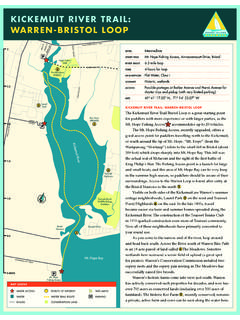
2 This is the CapitalRegional District at its start to finish, from east towest, here s a rundown on Trestle to Switch BridgeThe galloping goose regional Trailstarts at the east end of the JohnsonStreet bridge trailside kilometremarkers are measured from crossing the bridge, the trailcontinues as Harbour Road until itpicks up the paved trail near thePoint Ellice Bridge and skirts theUpper Harbour to the Selkirk Trestlenow less than a kilometre Selkirk Trestle a 300-metrelong, fir and hemlock trestle spansthe Selkirk Waters, a bulge in thenarrow saltwater inlet curvingnorth-west from Victoria s InnerHarbour to the Gorge and PortageBy Jim MulchinockThe Official Guide: The Official Guide: The galloping GooseRegional TrailThe galloping GooseRegional TrailMapsInside!
3 !(page 2)inlets. Though signs of a changingdowntown Victoria dominate thesouthern view, the immediate envi-rons are mostly tranquil, with lushpoplars, willows and maples pushingto the shoreline and softening theurban trestle itself is five metres wide ample room for the hundreds ofstrollers and cyclists on a Sundayafternoon outing. There s even roomfor the occasional fisher casting overthe railing for the trestle is wide, thesurface can get slippery afterwet weather. If you re onwheels, check your speed and watchout for other trail users. You canaccess the bridge at either end: fromthe south, take Tyee Road to ArthurCurrie Lane; from the north, dropdown from Gorge Road East, a blockwest of Jutland the bridge, in rapid succession,the trail scurries under the GorgeRoad East bridge and the BurnsideRoad East bridge.
4 A huge muralbrightens up one of the massive, castconcrete bridges. The goose emergesinto the warehouse and light indus-try district just west of DouglasStreet. It s stop-and-go here. Thetrail crosses six urban roads in arow. At many of them, you mustyield to road traffic, so stay alert. Upahead: the Switch Switch Bridge, a 100 metre spanacross the Trans-Canada Highway,marks another important milestonein the life of the goose . Until theSwitch Bridge, the busy highwayblocked flow along the goose . Whenthe bridge opened in 1996, the Goosegained easy, uninterrupted access Bridge to Quadra Street The Lochside regional TrailAt the north end of the SwitchBridge, the trail forks.
5 The right forkbends north-east and becomes thefirst section of the new LochsideRegional trail extending 35 kilome-tres to the Ferry Terminal at SwartzBay. Again, it quickly ducks undertwo major bridges: this time atBlanshard Street and Vernon re now in the heart of Saanich,the CRD s largest municipality with apopulation of 105,000. The LochsideTrail skirts around the southernperimeter of Swan Lake ChristmasHill Nature Sanctuary a greatopportunity for a side trip (sorry, nobicycles) if you re on foot. The ver-dant willows and hints of marshSpanning the WaterWhen the Selkirk Trestle openedin 1996, an important milestonewas achieved in the history of theGalloping goose regional trail : acontinuous multi-use trail nowlinked the communities of Victo-ria West and Saanich.
6 Severelydamaged in a fire in 1995, thetrestle was rebuilt, including ahand-winched, counter-weightdriven draw bridge to allow boatswith tall masts to navigate theinner waters.(page 3)wildlife beckon the asphalt travelerto explore Swan Lake to the north, theLochside crosses over the Brett Av-enue Trestle and 500 metres beyond,the Swan Lake Trestle, both rem-nants of the former Canadian North-ern Pacific Railway (and later theCNR) line that ran through Saanichfrom 1917 to Bridge to Atkins AvenueBack at the Switch Bridge, the leftfork heads west towards the WesternCommunities and points completion of the InterurbanRoad bridge, the Wilkinson Roadbridge, and the Helmcken underpasshas made life easier for anyone com-muting to work and cycling to andfrom the Western is straight and Trans-Canada Highway is aconstant companion to the south forthe next five kilometres.
7 To thenorth, Scotch broom and thebackyards of suburban Saanich com-plete the vistas and hurry the com-muting cyclist to View Royal you ll catch aglimpse of Portage Inlet to the south,glass-like on a quiet day, the termi-nus of a saltwater inlet that beganway back in Victoria Harbour. Thissection of the trail dips and winds itsway into View last, the Atkins Avenue parkinglot. Shortly beyond here, say goodbyeto the paved, asphalt goose ; hello tothe compacted, former rail-bed andwith it a subtle change in the goose scharacter. The trail sheds its urbanbackyard-and-sidestreet clothes andgoes rural and rough.
8 Well, roughenough for most of us. It s still a nicefamily journey. You just have to payattention to bumps in the track, theodd overhanging branch, and theoccasional mud lake for all seasonsThe Swan Lake Christmas HillNature Sanctuary is worth a tripon its own. The 58 hectare sanc-tuary protects the marshy low-lands around Swan Lake and thehigh, rocky Garry oak outcrops ofnearby Christmas Hill. You canspend an easy half day herestrolling along trails (including afloating boardwalk) and watchingelusive birds, muskrat, river otterand mink. The Nature House fillsout the trip with exhibits and areading room.
9 The Sanctuary alsooffers guided events for (250) 479-0211 for Avenue to MetchosinJust west of the Atkins Avenue park-ing lot, the goose crosses Six MileRoad. For those with more time toexplore, visit nearby Thetis LakeRegional Park, a popular 635 hectarepark with a variety of activities fromswimming at a beach to nature studyin a Douglas fir forest. Take the sidepath down to Six Mile Road, turnright (north) and follow Six Mile forabout a kilometre to the main gate. Ifyou re cycling, some of the ThetisLake trails are accessible to moun-tain bikes. Bicycle racks are the next seven kilometresthe goose rides over top ofthe Colwood Delta an im-mense pile of gravel, up to 100 me-tres thick, underlying much ofLangford and Colwood.
10 It was builtnearly 13,000 years ago by streamsflowing to the sea from glacial icewest of Langford Lake. You can t seethe delta as such (it s under foot)but you can see some of the left overmeltwater channels and crossings interrupt the flow ofthe goose all the way to the Luxton(page 4)Cont'd onpage 9 Rocky Point RoadKangaroo RoadLindholm RoadSooke RoadHappy Valley RoadTaylor LombardWilliam Head RoadMetchosin RoadMetchosin RoadParry BayPedder BayDEVONIANREGIONALPARKGlenLakeJacklin Road29302827242321201918PP22 METCHOSINL angfordLakeLuxtonFairgroundsMetchosinSch oolALBERTHEADREGIONAL PARKWITTY'S LAGOONREGIONAL PARK251726 Cont'd onnext pageVICTORIAMETCHOSINSOOKESAANICH page 4page 5 regional trail (EasFairgrounds.)