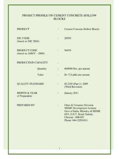
Transcription of CONTENTS
1 CONTENTS . S. No. Topic Page No. 1. General Characteristics of the District 3. Location & Geographical Area 3. Topography 4. Availability of Minerals. 4. forest 4. Administrative set up 5. 2. District at a glance 5-6. Existing Status of Industrial Area in the District Bhopal 7. 3. Industrial Scenario Of Bhopal 8. Industry at a Glance 8. Year Wise Trend Of Units Registered 9. Details Of Existing Micro & Small Enterprises & Artisan Units 10. In The District Large Scale Industries / Public Sector undertakings 11. Major Exportable Item 11. Growth Trend 11. Vendorisation / Ancillarisation of the Industry 11. Medium Scale Enterprises 11.
2 List of the units in Bhopal & nearby Area 11. Major Exportable Item 12. Service Enterprises 12. Potentials areas for service industry 12. Potential for new MSMEs 12. 4. Existing Clusters of Micro & Small Enterprise 12. Details of major cluster 13. Manufacturing Sector 13. Service sector 13. Details of Identified Cluster 13. Name of the cluster 13. 5. General issues raised by industry association during the course of 13. meeting 6 Steps to set up MSMEs 14. 2. Brief Industrial Profile of Bhopal District 1. General Characteristics of the District Bhopal is located in the central part of India, and is just north of the upper limit of the Vindhya mountain ranges.
3 Located on t he Malwa plateau, it is higher than the north Indian plains and the land rises towards the Vindhya Range to the south. The city has uneven elevation and has small hills within its boundaries. The major hills in Bhopal comprise of Idgah hills and Shyamala hills in the northern region and Arera hills in the central region. Location & Geographical Area. Bhopal District is bounded by the districts of Guna to the north, Vidisha to the northeast, Raisen to the east and southeast, Sehore to the southwest and west, and Rajgarh to the northwest. The city of Bhopal lies in the southern part of the district, and the majority of the population resides within Bhopal municipality.
4 The town of Berasia lies in the northern part of the district. 3. TOPOGRAPHY. Bhopal city nestles in a hilly terrain, which slopes towards north and southeast. Hillocks of different altitudes are situated along the southwest and northwest portion of the city, these hillocks from a continuousbelt from Singarcholi up to Vindhyachal range. The height of Singarcholi nearLalghati is 625 M ., which is maximum in this area. The general ground level ishowever, nearly 460 M . along the southeastern and northeastern portion ofthe city. The remarkable topography of thecity provides enchanting and panoramic views of the city and of natural scenic beauty.
5 There are immense possibilities for landscaping and water front Development for recreation Source: Internet forest Total Geogoraphical Area of Bhopal district is 2772 Sq. Km of which Dense forest is 41 Sq. Km, Open forest 192 Sq. Km. Total forest Area is 233 Sq. Km Extending over % of the total geographical area. Source : Internet Availability of Minerals: PRODUCTION OF MINERAL 2010-11. NAME OF MINERAL PRODUCTION Cubic Meter 2010-2011. MAJOR. MINERAL. 1. Nil ---- MINOR. 1. Stone Dhoka 45146. 2. Stone 90285. 3. Clay 18599. 4. Murum 801161. 5. Sand 94036. Source:- Dept. Of Mines & Geology., 4. Administrative Set Up. 2. District at a Glance Particular Year Unit Statistics 1 Geographical features (A) Geographical Data i) Latitude & ii) Longitude & iii) Geographical Area Hectares 277200.
6 (B) Administrative Units i) Tehsils 2011 Nos 02. iii) Sub-Tehsil 2011 Nos ----- iv) Janpad Panchayat 2011 Nos 02. v) Zila Pachayat 2011 Nos 01. vi)Nagar nigam 2011 Nos 01. Nagar palika 02. vii) Gram Shaba 2011 Nos 195. viii) Gram Panchayats 2011 Nos 492. xi) Revenue villages 2011 Nos 517. x) Assembly Area 2011 Nos 07. 2. Population (A) Sex-wise i) Male 2011 Nos 1239378. ii) Female 2011 Nos 1128767. (B) Rural Population 2011 Nos 453806. 3. Agriculture A. Land utilization i) Total Area 2010-11 Hectare 277200. ii) forest cover 2010-11 42309. iii) Non Agriculture Land 2010-11 35695 hact. v) cultivable Barren land 2010-11 88434.
7 4. forest (i) forest 2010-11 Sq. KM. 233. 5. Livestock & Poultry A. Cattle i) Cows 2007 Nos. 134753. ii) Buffaloes 2007 Nos. 86500. B. Other livestock i) Goats 2007 Nos. 61053. ii) Pigs 2007 Nos. 4238. 5. iii) Dogs & Bitches 2007 Nos. --- iv) Railways i) Length of rail line 2010-11 Kms 70. V) Roads (a) National Highway 2010-11 Kms 20. (b) State Highway 2010-11 Kms 231. (c) Main District Highway 2010-11 Kms 1079. (d) Other district & Rural Roads 2010-11 Kms (e) Rural road/ Agriculture 2010-11 Kms 927. Marketing Board Roads (f) Kachacha Road 2010-11 Kms 1030. (VI) Communication (a) Telephone connection 2010-11 115597. (b) Post offices 2010-11 Nos.
8 140. (c) Telephone center 2010-11 Nos. 17. (d )Density of Telephone 2010-11 --- person (e) Density of Telephone 2010-11 No. per KM. --- (f) PCO Rural / Urban 2010-11 No. 650. (h) Mobile 2010-11 No. (VII) Public Health (a) Allopathic Hospital 2010-11 No. 41. (b) Beds in Allopathic No. 568. hospitals (c) Ayurvedic Hospital No. 10. (d) Beds in Ayurvedic No. hospitals (e) Unani hospitals No. 3. (f) Community health No. centers 9. (g) Primary health centers No. (h) Dispensaries 205. (i) Sub Health Centers No. 63. (j) Private hospitals No. 96. (VIII) Banking commercial (a) Commercial Bank 2010 Nos. 60. (b) rural Bank Products 2010 Nos.
9 03. (c) Co-Operative bank 2010 Nos. 04. products 2010. (d) PLDB Branches 2010 Nos. 58. 6. (IX) Education 2010. (a) Primary school 2010 Nos. 1108. (b) Middle schools 2010 Nos. 1295. (c) Secondary & senior 2010 Nos. 575. secondary schools 2010. (d) Colleges 2010 Nos. 106. (e) Technical University 2010 Nos. 2. Source : DTIC, Bhopal Existing Status of Industrial Areas in the District Bhopal S. Name of Ind. Land Land Prevaili No of No of No of No. of No. Area acquired develop ng Rate Plots allotte Vacant Units (In ed Per d Plots in hectare) (In Sqm Plots Produ hectare) (In Rs.) ction 1 Indl Area --- --- 1143 1143 --- 1143. Govindpura, 2 Kaliparad --- --- 34 34 --- 34.
10 3 Press --- --- 10 10 --- 10. Complex 4 Bandikhedi --- --- 160 --- --- 148. LOI. issued Total --- --- 1347 1187 --- 148. LOI. issued Source : DTIC, Bhopal 7. 3. Industrial Scenario of Bhopal Industry at a Glance Sr Head Unit Particulars No 1. Registered Industrial Unit No. 10989. 2. Total Industrial Unit No. 12400 (Approx). 3. Registered Medium & Large Unit No. 19. 4. Estimated Avg. No. Of Daily Worker No. 34599. Employed In Small Scale Industries 5. Employment In Large And Medium No. 11927. Industries 6. No. Of Industrial Area No. 04. 7. Turnover Of Small Scale Ind. In Lacs 460000. 8. Turnover Of Medium & Large Scale In Lacs 625000.