Example: tourism industry
Cyclone Global Navigation Satellite System - NASA
Cyclone Global Navigation Satellite System (CYGNSS) will measure surface winds in and near the inner core of hurricanes, including regions beneath the eyewall and intense inner rain-bands that could not previously be measured from space. These measurements
Tags:
Information
Domain:
Source:
Link to this page:
Documents from same domain
Q: What do you do on the International Space …
www.nasa.govQ: What do you do on the International Space Station (ISS)? A: Astronauts and cosmonauts on the space station stay busy.There’s lots of work to operate the many science experiments on board.
NEPA RECORD OF ENVIRONMENTAL …
www.nasa.govDec 13, 2012 · JSC Form 1119 (Revised January 25, 2011)(MS Word October 2010) NEPA RECORD OF ENVIRONMENTAL CONSIDERATION (REC) Complete this form if you answered “yes” or “unknown” on any JF 1138 entries and if
Use of XSLT to transform the output of multiple …
www.nasa.govNASA IV&V International Workshop 2014 1 Use of XSLT to transform the output of multiple Static Code Analysis tools into a consistent analysis spreadsheet format
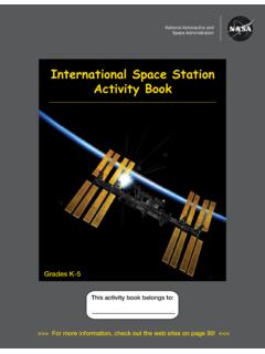
International Space Station Activity Book
www.nasa.govNational Aeronautics and Space Administration . Grades K-5 . This activity book belongs to: International Space Station Activity Book >>> For more information, check out the web sites on page 30!
Gravity, Who Needs It
www.nasa.govGravity, Who Needs It? ... six months on the space station versus three years on a Mars mission? No. ... human, being more isolated ...
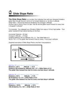
Glide Slope Ratio
www.nasa.govGlide Slope Ratio The Glide Slope Ratio is a number that indicates how well your designed shoebox glider flies through the air in terms of its forward distance vs. its drop in altitude. Glide Ratio = Horizontal Distance divided by the Change in Altitude.
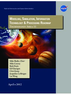
Modeling, SiMulation, inforMation technology & …
www.nasa.govTA11-1 exeCuTive Summary Figure 1 is an initial draft strategic roadmap for the Modeling, Simulation, Information Technol-ogy and Processing Technology Area.
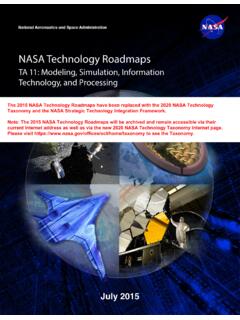
NASA Technology Roadmaps
www.nasa.gov2015 NASA Technology Roadmaps TA 11: Modeling, Simulation, Information Technology, and Processing TA 11- 2 July 2015 Foreword NASA is leading the way with a balanced program of space exploration, aeronautics, and science research.
A Journey to Inspire, Innovate, and Discover
www.nasa.govReport of the President’s Commission on 2 Implementation of United States Space Exploration Policy Transmittal Letter June 4, 2004 The Honorable George W. Bush
National Aeronautics and Space Administration Headquarters
www.nasa.govGEMS is a Category 3 project (less than $250M) in Phase B, and was requesting transition from Formulation to Implementation (Phase C) where the official Agency baseline is established and external commitments are made
Related documents
Current and Planned Global and Regional Navigation ...
www.unoosa.orgThe Global Navigation Satellite System 13 III. European Union The European Satellite Navigation System and the European Geostationary Navigation Overlay Service 19 IV. China The Compass/BeiDou Navigation Satellite System 35 V. Japan The Multi-functional Transport Satellite Satellite-based
Keysight Technologies Signal Studio for Global Navigation ...
literature.cdn.keysight.comSimplify Global Navigation Satellite System (GNSS) Signal Creation Signal Studio software is a flexible suite of signal-creation tools that will reduce the time you spend on signal simulation. For GNSS, including GPS, GLONASS, Galileo,
UTILIZATION OF MODERNIZED GLOBAL NAVIGATION …
web.stanford.eduAn increased number of Global Navigation Satellite System (GNSS) space vehicles, broadcasting at multiple civilian frequencies, are expected to become oper- ational over the next decade.

NAVSTAR, the Global Positioning System: A Sampling of Its ...
history.nasa.govGlobal positioning System (GpS), the irst satellite navigation system that enabled users to determine precisely their location in three dimensions and time within billionths of a second, grew from a concept into a fully
Global Navigation Satellite Systems: Genesis, State of the ...
gps.mae.cornell.eduGlobal Navigation Satellite Systems: Genesis, State of the Art, and Future ... (Global Navigation Satellite Systems) in order o denote both systems without givingt precedence to either. ... The Global Positioning System (GPS) is being used in a variety of important and unusual applications. One example is the Joint Precision Approach and ...
Global Navigation Satellite System (GNSS)
www.princeton.eduSatellite Systems (GNSS) such as Global Positioning System (GPS), cellular network infrastructure or on the integration of the two technologies for a wide spread of applications such as Automatic Vehicle Location (AVL), tracking systems, navigation, Pedestrian Navigation
GLOBAL NAVIGATION SATELLITE SYSTEM GLONASS
russianspacesystems.ruGLONASS – Global Navigation Satellite System ICD – Interface Control Document IS – Initial State L1OC – CDMA Open Service Navigation Signal in L1 frequency band L1OCd time – time scale determined by phase of L1OCd signal at the phase center of an SV antenna

Global Navigation Satellite Systems: Educational curriculum
www.unoosa.orgGlobal Navigation Satellite Systems (GNSS) include constellations of Earth-orbiting satellites that broadcast their locations in space and time, of networks of ground control stations, and of receivers that calculate ground positions by trilateration.
Global Navigation Satellite System Implementation Team ...
mddb.apec.orgPage 1 Final Report The 22st Meeting of the APEC GNSS Implementation Team (GIT/22) 25 – 28 April 2017, Taipei, Chinese Taipei 1. GENERAL The 22nd Meeting of the Asia Pacific Economic Cooperation (APEC) Global Navigation Satellite System (GNSS) Implementation Team (GIT/22) was hosted by Chinese Taipei from
GLOBAL NAVIGATION SATELLITE SYSTEM GLONASS
russianspacesystems.ru1.1 The Global Navigation Satellite System (GLONASS) is used to provide positioning, velocity and precise time for marine, air, terrestrial, and space users, as well as to …
Related search queries
Global, Navigation, Global Navigation Satellite System, Satellite navigation system, Navigation Satellite System, Satellite Satellite, Global Navigation, UTILIZATION OF MODERNIZED GLOBAL NAVIGATION, Global positioning System, Global Navigation Satellite Systems: Genesis, State, Global Navigation Satellite, System, Global Navigation Satellite System GNSS, Satellite, Global Navigation Satellite System Implementation Team, Global Navigation Satellite System GLONASS