Example: marketing
FIVE-DAY BIOCHEMICAL 7.0 OXYGEN DEMAND - USGS
for biochemical oxygen demand that is used in the National Water Information System (NWIS) of the U.S. Geological Survey. The citation for this section (7.0) of NFM 7 is as follows: Delzer, G.C., and McKenzie, S.W., November 2003, Five-day biochemical oxygen demand: U.S. Geological Surv ey Techniques of Water-Resources
Tags:
Information
Domain:
Source:
Link to this page:
Documents from same domain

U.S. Department of the Interior U.S. Geological Survey ...
pubs.usgs.govU.S. Department of the Interior U.S. Geological Survey Natural Gemstones Searching for gemstones in the United States is a popular recreational activity for collectors and hobbyists ... Gems, when present at all, tend to be scat tered sparsely throughout a large body of

U.S DEPARTMENT OF THE INTERIOR U. S. …
pubs.usgs.govu.s department of the interior u. s. geological survey magnetic susceptibility measurements and sample locations of granitic rocks from along a transect of the coast mountains near

GEOLOGICAL SURVEY - USGS
pubs.usgs.govunited states geological survey charles d. walcott, director oil and gas fields of the bias coal and of the upper cretaceous and tertiary of the

Groundwater-Level and Storage-Volume Changes in …
pubs.usgs.govGroundwater-Level and Storage-Volume Changes in the Equus Beds Aquifer near Wichita, Kansas, Predevelopment through January 2015 By Joshua A. Whisnant, Cristi V. Hansen, and Patrick J. Eslick

Status of Groundwater Levels and Storage Volume …
pubs.usgs.govvolume in the Equus Beds aquifer near Wichita, south-central Kansas, predevelopment to winter 2014 ...

Student Guide Tracking Change Over …
pubs.usgs.govWhat is remote sensing? Remote sensing means observing something from a distance. ... Student Guide Tracking Change Over Time—Understanding Remote Sensing

Weak-Field Magnetic Susceptibility Anisotropy and …
pubs.usgs.govWEAK-FIELD MAGNETIC SUSCEPTIBILITY ANISOTROPY AND ITS DYNAMIC MEASUREMENT By WILLIAM F. HANNA ABSTRACT The apparent magnetic susceptibility, KA, …

FEATURES SHOWN ON TOPOGRAPHIC MAPS - USGS
pubs.usgs.govFEATURES SHOWN ON TOPOGRAPHIC MAPS Contents Abstract ... Besides the colors used for the three main classes of features, green is used to show wood ...

Porosity and Bulk Density of Sedimentary Rocks
pubs.usgs.govPOROSITY AND BULK DENSITY OF SEDIMENTARY ROCKS ... the average and range of porosity, ... Total porosity is a measure of all the void space of porous material.

Gem Stones of the United States
pubs.usgs.govGems are named for their color, type locality, outstanding physical property, or persons. The most popular gem cuts are the cabochon, rose, brilliant, step, and mixed. The carat, one-fifth of a gram or 200 milligrams, is the unit of weight measure ... PRECIOUS GEMS. GEM STONES OF THE UNITED STATES. GEM STONES OF THE UNITED STATES. GEM STONES ...
Related documents
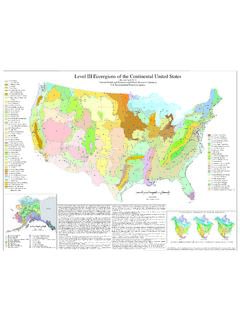
Level III Ecoregions of the Continental United States
gaftp.epa.govNational Health and Environmental Effects Research Laboratory U.S. Environmental Protection Agency 57. Huron/Erie Lake Plains 58. ... have been used to develop regional biological criteria and water quality standards, set management goals for nonpoint ... of North Dakota and South Dakota (map poster). U.S. Geological Survey, Reston, VA. Scale 1 ...

Methods of Data Collection, Sample Processing, and Data ...
pubs.usgs.govand the Sand County Foundation, the U.S. Geological Survey (USGS) Wisconsin Water Science Center (WWSC) installed, maintained, and operated equipment to collect water-quantity and water-quality data from 25 edge-of-field, 6 streamgaging, and 5 subsurface-tile stations at 7 Discovery Farms and Pioneer Farm. The farms are located
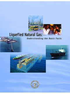
Liquefied Natural Gas - Energy
www.energy.govNational Energy Technology Laboratory, which is the Department’s lead center for the research and development of advanced fossil energy technologies. NARUC, a nonprofit organization composed of governmental agencies engaged in the regulation of telecommunications, energy, and water utilities and carriers in the 50 states, the
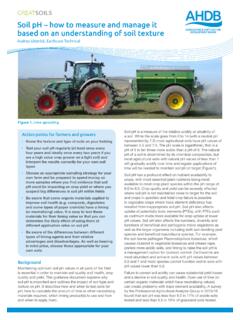
Soil pH – how to measure and manage it based on an ...
www.soilassociation.orgAug 02, 2017 · and a decline in soil quality and health. Over-use of lime (or certain organic materials which have neutralising values) can create problems with trace element availability. A survey by the Professional Agricultural Analysis Group in 2015/16 found that soil pH was less than 6.0 in 17% of arable soils

Buildings and their Impact on the Environment: A ... - US EPA
archive.epa.govApr 22, 2009 · same period, public demand for water more than tripled! Americans now use an average of 100 gallons of water each day—enough to fill 1,600 drinking glasses. 14 • Faucets account for more than 15 percent of indoor household water use—more than 1 trillion gallons of water across the United States each year. Showering
IS 2386-1 (1963): Methods of Test for Aggregates for ...
www.iitk.ac.inIS : 2386 ( Part I ) - 1963 Indian Standard METHODS OF TEST FOR AGGREGATES FOR CONCRETE PART I PARTICLE SIZE AND SHAPE 0. FOREWORD 0.1 This Indian Standard (&rt I) was adopted by the Indian Standards Institution …