Transcription of Hurricane Patricia - National Hurricane Center
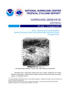
1 National Hurricane Center . TROPICAL CYCLONE REPORT. Hurricane Patricia . (EP202015). 20 24 October 2015. Todd B. Kimberlain, Eric S. Blake, and John P. Cangialosi National Hurricane Center 4 February 20161. METOP-B ENHANCED INFRARED SATELLITE IMAGE AT 0323 UTC 23 OCTOBER. IMAGE COURTESY CIRA. Patricia was a late-season major Hurricane that intensified at a rate rarely observed in a tropical cyclone. It became a category 5 Hurricane (on the Saffir-Simpson Hurricane Wind Scale) over anomalously warm waters to the south of mexico , and the strongest Hurricane on record in the eastern North Pacific and North Atlantic basins. The Hurricane turned north-northeastward and weakened substantially before making landfall along a sparsely populated part of the coast of southwestern mexico as a category 4 Hurricane . Patricia produced a narrow swath of severe damage and two direct deaths.
2 1 Original report date 1 February 2016. Updated 4 February to correct storm chaser report, peak 24-h pressure fall, Hurricane Linda's peak intensity in Fig. 6, and the date of Hurricane Lane. Hurricane Patricia 2. Hurricane Patricia 20 24 OCTOBER 2015. SYNOPTIC HISTORY. Patricia 's development into a tropical cyclone was slow and complicated, involving the interaction of multiple weather systems. A tropical disturbance crossed the southern part of Central America on 11 October, and entered the eastern Pacific the following day several hundred nautical miles south of El Salvador. While this system moved little, a tropical wave was moving westward over the caribbean Sea, and reached Central America on 15 October. The wave moved into the eastern Pacific the next day and merged with the first disturbance while a gulf of Tehuantepec gap wind event was occurring.
3 The gap wind event provided an injection of cyclonic vorticity to the merged disturbance (Levine 2012, Holbach and Bourassa 2014), and an elongated area of low pressure formed later that day, extending from the Yucatan Peninsula southward for several hundred miles into the eastern Pacific. Deep convection associated with the large cyclonic gyre increased substantially on 17 October, possibly due to more favorable large-scale conditions associated with the passage of the rising branch of a strong Madden-Julian Oscillation moving eastward across the eastern Pacific. The system's cloud pattern was gradually becoming better organized while it moved slowly northwestward to a position a few hundred nautical miles south of the gulf of Tehuantepec on 18. October, where it developed a smaller and better defined circulation. However, a second gap wind event, stronger than the first, began later that day.
4 Although this gap wind event initially had a disruptive effect on the formative tropical cyclone, the low reformed to the northeast later on 19. October on the cyclonic shear side of the strengthening gap wind event. Deep convection associated with the low increased and became well organized by early on 20 October. An ASCAT. pass around 0400 UTC 20 October suggested that a small, well-defined circulation had developed underneath the convection within a larger cyclonic envelope elongated from north to south, and it is estimated that a tropical depression finally formed around 0600 UTC that day centered about 180 n mi south-southeast of Salina Cruz, mexico . The best track chart of the tropical cyclone's path is given in Fig. 1, with the wind and pressure histories shown in Figs. 2 and 3, respectively. The best track positions and intensities are listed in Table 12.
5 The depression was located to the south of a mid-level ridge centered over the gulf of mexico , extending west-southwestward into the eastern Pacific. The steering provided by this feature and the gap wind event caused the depression to drift west-southwestward while the cyclone gradually strengthened, and the system became a tropical storm 18 h after genesis. By early on 21 October Patricia encountered relatively drier and more stable lower- to middle- tropospheric air, and sea surface temperatures that were at least 2 C lower than the surrounding 2 A digital record of the complete best track, including wind radii, can be found on line at Data for the current year's storms are located in the btk directory, while previous years' data are located in the archive directory. Hurricane Patricia 3. region, the result of strong gap winds over a large area extending well to the south of the Isthmus of Tehuantepec.
6 The less favorable thermodynamic environment slowed development, with deep convection temporarily diminishing and cloud-top temperatures warming late on 20 October and early on 21 October. Once Patricia moved outside of the affected region later that morning, however, a rapid increase in deep convection occurred over the low-level Center , and a small central dense overcast (CDO) began to form while the storm moved at a faster forward speed toward the west and then the west-northwest. A NOAA Hurricane Hunter aircraft reached Patricia that afternoon and discovered it to already be a 50-kt tropical storm, consistent with the rapid increase in organization of the cloud pattern seen in satellite imagery. A period of rapid intensification had already begun in an environment of very light vertical wind shear, high atmospheric moisture and greater instability over anomalously warm waters, untapped since Hurricane Carlos traversed the region in June.
7 Patricia strengthened into a Hurricane shortly after 0000 UTC 22 October while centered about 200 n mi south of Acapulco, mexico . Over the next 24 h, Patricia 's satellite presentation changed dramatically, as a large band with cloud-top temperatures of -80 to -90 C coiling cyclonically inward over the Center evolved into an almost perfectly symmetric CDO around a 10 n mi wide eye. A NOAA plane arrived at the end of this 24-h period around 1800 UTC 22 October, and indicated that Patricia had already reached major Hurricane strength, with estimated surface winds of 115 kt and a minimum pressure of 957 mb. The rapid intensification phase continued into the night while Patricia turned northwestward and its forward speed decreased, and satellite imagery indicated that a solid ring of cloud-top temperatures colder than -90 C surrounding a 7 n mi wide eye had formed by 0300.
8 UTC 23 October (cover figure). By the time an Air Force Hurricane Hunter aircraft reached the cyclone around 0600 UTC, Patricia had intensified into an extremely powerful Hurricane with maximum sustained winds of 180 kt and a minimum central pressure of around 879 mb. The satellite presentation continued to increase in organization over the next several hours after the plane left, and Patricia is estimated to have reached a peak intensity of 185 kt around 1200 UTC. that day while centered about 130 n mi southwest of Manzanillo, mexico . Patricia reached the western periphery of the mid-level ridge centered over the gulf of mexico around this time and turned north-northwestward and then northward while essentially maintaining its intensity. By the time the last reconnaissance mission reached Patricia around 1800 UTC 23 October, the Hurricane had turned north-northeastward with some increase in forward speed, in response to a shortwave trough moving across the Baja California peninsula and northwestern mexico .
9 Although the aircraft still found surface winds of near 180 kt on its first pass through the storm in the southeastern quadrant, a 2023 UTC Global Precipitation Mission (GPM) overpass indicated a distinct double eyewall structure (Fig. 4), suggestive of an imminent weakening trend. Upper-air analyses also indicated that southwesterly vertical wind shear was gradually increasing over the cyclone, and a final pass by the plane around 2030 UTC indicated that a rapid filling of the cyclone had begun; the peak flight-level winds had decreased nearly 50. kt in the same quadrant traversed earlier and the central pressure had risen 24 mb in the 3 h since the first fix. Patricia continued to rapidly weaken during the next couple of hours before landfall, and is estimated to have reached the southwestern coast of mexico in the state of Jalisco, near Playa Cuixmala, around 2300 UTC 23 October with an intensity of 130 kt and a minimum pressure of around 932 mb.
10 The Hurricane continued to weaken rapidly during the next several hours while Hurricane Patricia 4. it moved over the high terrain of the Sierra Madre mountains, and Patricia fell below Hurricane strength before passing well to the west of Guadalajara around 0300 UTC 24 October. When the mid-level Center raced northeastward and separated from the low-level Center overnight, Patricia weakened to a tropical depression. The cyclone dissipated later that morning over central mexico . METEOROLOGICAL STATISTICS. Observations in Patricia (Figs. 2 and 3) include subjective satellite-based Dvorak technique intensity estimates from the Tropical Analysis and Forecast Branch (TAFB) and the Satellite Analysis Branch (SAB), and objective Advanced Dvorak Technique (ADT) estimates from the Cooperative Institute for Meteorological Satellite Studies/University of Wisconsin-Madison.