Transcription of LESSON 3: AFRICA’S CLIMATE REGIONS
1 1 LESSON 3: africa S CLIMATE REGIONS Key Concepts You must know, or be able to do the following: Name, understand the characteristics and position of africa s major CLIMATE REGIONS Be able to link the African Continent circulation to Global Tri-cellular circulation with particular reference to areas of uplift (rain) and subsidence (dry) Identify the major ocean currents around africa and the influence on CLIMATE control over africa Fully understand the processes of El Nino and La Nina and their effects on African CLIMATE Be able to interpret synoptic charts of South africa with special reference to air movements, interpretation of station models and the dominant pattern of High Pressures that affect the CLIMATE .
2 Much of this is a recap from Grade 10. X-PLANATION Characteristics and Position of africa s Major CLIMATE REGIONS africa s position is relatively unique in the sense that it almost has a mirror image of CLIMATE zones to the north and South of the Equator with regard to latitude. The six main CLIMATE zones of africa are found to the north and south of the equator, namely, Equatorial, Humid Tropical, Tropical, Semi-desert (Sahalian), Mediterranean and Desert. A CLIMATE region is an area with similar temperature and rainfall. In Grade 10, you learnt about several factors that influence the CLIMATE of different places in the world.
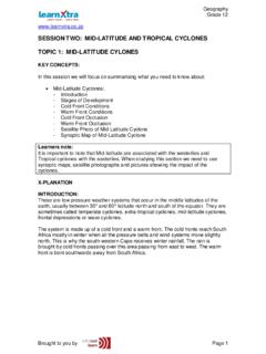
3 These are: Latitudinal position altitude Distance from the sea Prevalent pressure belts Ocean currents. Considering this, africa has a large variety of different climates. 2 Map of africa CLIMATE Zones Desert 18 - 36 N & S of the Equator Sub-tropical HP zone West coast and Continental effect Cold Canary Current and Cold Benguela Current Equatorial 10 N & S of the Equator ITCZ Continental mainly with west coast warm current Tropical (Savannah) 15 to 20 N & S of the Equator Sub-tropical HP over region in winter Summer rainfall region prone to droughts and tornadoes Large temperature ranges Mediterranean 30 - 40 N & S of the Equator Situated on the furthest north and south west margins of the African continent Winter rainfall brought on by temperate cyclones (cold fronts) Maritime Sahelian (semi-desert) 20 N of Equator Transition between Monsoon and desert zones ITCZ moves N -summer rainfall Mainly Continental effect Humid Tropical Transition between Equatorial and Tropical (Savannah)
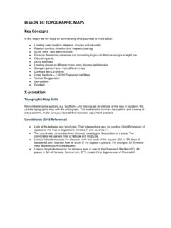
4 Rainfall throughout the year more in summer Small variations in temperature 20 - 25 C High temperatures due to tropical location Figure 1 Map of africa showing the various Climatic REGIONS Adapted 3 Subsidence and Convergence in africa africa straddles the Equator from 37 N to 34 S. africa has two Sub-tropical belts with the ITCZ somewhat equidistant from the two high pressure zones. The ITCZ (also known as the heat Equator) moves between the Tropics of Cancer and Capricorn depending on the season. This is the area of massive uplift over africa and very high rainfall figures are measured.
5 The sub-tropical High Pressure Belt also migrates with the seasonal movement of the overhead sun. Areas in africa have their rainfall season when the heat Equator moves into its respective hemisphere. Figure 2 is more simplified. It shows conditions for an Equinox with the overhead sun over the Equator. Figure 2 Subsidence and convergence (link to rainfall) in africa Adapted The Role of Oceans in Climatic Control in africa The ocean covers more than 70 % of the Earth s surface. The ocean plays a major role in regulating the weather and CLIMATE of the planet. Oceans in general have a great influence on rainfall on a continental basis and an influence on temperatures along coastal margins.
6 Figure 3 is an isotherm map that shows ocean temperatures around africa . If the ocean currents are superimposed on this map, there will be a striking correlation between the cold ocean currents and colder waters and warm ocean currents and warm waters. Figure 3 Adapted 4 Isotherm: Line joining places of the same temperatures Temperature The effect of the ocean with regard to temperature is Maritime in effect. Generally, when looking at temperature of oceans and currents around the coast of africa , there is a dominance of warm water around the continent. The exceptions are the North West and the South West coastlines, (Cold Canary and the Cold Benguela currents, respectively.)
7 Both Mediterranean areas are cooler than expected due to cloud cover in winter as cold fronts move through and lessen insolation. These areas are marked on Figures 3 & 4. Since South africa is surrounded by water masses, all coastline temperatures are moderated and have small temperature ranges. Figure 4 Ocean currents around africa Adapted Rainfall The map of average rainfall over africa annually shows a similarity to the maps that show climatic REGIONS . The effect of ocean temperatures and currents has a maritime and continental effect. This together with the migration of the heat Equator presents a rainfall pattern of considerably more rainfall over Sub-Saharan africa .
8 Figure 5 Average annual precipitation for africa 5 Processes of El Nino and La Nina and their effects on African CLIMATE The effects of La Nina and El Nino are part of what is called the Southern Oscillation. In africa , there are two main areas affected where dry areas receive more rainfall, while, the wet areas receive less rainfall. The two areas are shown on Figure 6 &7. The Southern Oscillation originates over the Pacific Ocean. This changes the normal pressure patterns over the entire Earth s surface. With changing pressure, winds are affected. Simply, this means that areas that would normally be moist are dry and visa-versa.
9 Figure 6 Adapted Figure 7 6 The effects of the Southern Oscillation are graphically represented in Figure 8 where distinct times of below average and above average rainfall are noticeable. Figure 8 Rainfall fluctuations in africa 1900 2000 Interpretation of synoptic charts of South africa with special reference to air movements and interpretation of station models Synoptic Charts Synoptic charts are drawn 4 times a day at Greenwich Mean Time. We are 2 hours ahead in South africa . Hence we create synoptic maps at 02:00, 08:00, 14:00 and 20:00. This allows for weather stations throughout the world to collect weather data at exactly the same time.
10 Climatologists are then able to create a global weather picture. CLIMATE data is collected by land based weather stations, islands (Marion and Gough) and ships. We are then able to plot the weather conditions to the west, south and east of South africa . The major information that can be used from a synoptic chart is: Isobars that determine wind direction and wind speeds, subsidence and uplift Station models that measure present weather conditions Lines of latitude and longitude to show the position of weather phenomena Observe approaching cold fronts (warm fronts seldom reach South africa ) Air Movements The TWO main surface circulation patterns of winds are those of High Pressures (Anticyclones) and Low Pressures (cyclones), shown by Figure9 These must be understood as to where winds come from and their nature.