Transcription of MLC/IHA Position Vacancy Announcement
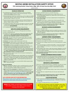
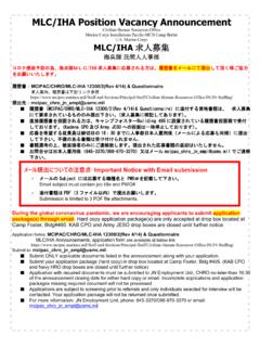
1 MLC/IHA Position Vacancy Announcement Civilian Human Resources Office Marine Corps Installations Pacific-MCB Camp Butler Marine Corps MLC/IHA /IHA MCIPAC/CHRO/MLC-IHA 12300/2(Rev 4/14) & Questionnaire MCIPAC/CHRO/MLC-IHA 12300/2(Rev 4/14)& Questionnaire ( ) Building 495 (Kadena CPO Army JESO ) 16 30 645-3370/098-970-3370 During the global coronavirus pandemic, we are encouraging applicants to submit application package(s) through email. Hard copy application package(s) are only accepted at drop box located at Camp Foster, Bldg#495.
2 KAB CPO and Army JESO drop box are closed until further notice. Application: MCIPAC/CHRO/MLC-IHA 12300/2(Rev 4/14) & Questionnaire MLC/IHA Announcements, application form are available at below link Submit to: Submit ONLY applicable documents listed in the Announcement along with your application. Submit your application package (hard copy) in drop box located at Camp Foster, Bldg #495. (KAB CPO and Navy HRO drop box are closed until further notice) Application with required documents must be submitted to JN Employment Unit, CHRO no-later-than 16:30 of the Announcement closing date for either hard copy or email. Incomplete applications and application packages missing required document will not be processed. Applications are subject to screening prior to referrals and only individual selected for interview will be contacted.
3 Your application package will not be returned once submitted. For more information: JN Employment unit, phone: 645-3370/098-970-3370 or email to: Important Notice with Email submission - Subject PWO Email subject must contain job title and PWO# - PDF 3 Submission is limited to 3 PDF files including resume and attachments. 4 Feb 22 Announcement No. 15-22 PWO #: 028 Position title: IT Specialist (Cust Spt/Data Mgmt), #549, BWT-1, Grade-6, LPL-3 MLC F/T Permanent Number of Position (s): 1 Location: Camp Foster Organization: G-F Div, Facilities Systems Management Br. Area of consideration : Japan Wide (MLC/IHAs employed in Okinawa) MLC/IHA Closing date: 15 Feb 22 Summary of duties: Performs data management duties as assigned by the IGI&S program manager.
4 Independently develops and carries out assignment using general directions and other supplementary instructions, applying knowledge and experience to resolve issues. Keeps colleagues informed, IGI&S manager and consult with IGI&S section of important development and periodically presents current status of all work for technical and administrative considerations. Works with Subject Matter Experts (SMEs) to obtain and validate accurate and up-to-date geospatial data. Creates and maintain geospatial data in support of data collection, geospatial analysis, or mapping projects to include geometry, attribution, and metadata using a wide range of methods. Reviews existing and incoming data for currency, accuracy, usefulness, quality, appropriate documentation, and compliance with Marine Corps (USMC) geospatial data standards and models. Identifies and documents metadata in accordance with established standards, including data source, scale, map projection, and attribute information.
5 Ensures enterprise geospatial data complies with Marine Corps Quality Assurance Plan(s). Develops geospatial editing templates, scripts, and workflows that increase performance and meet data quality metrics. Protects data by applying information security (IS) practices. Processes visualization service requests from USMC organizations, DoD entities, and other government agencies (federal, state, local) using established policies, procedures, and tools. Coordinates with Region or Installation organizations and tenant representatives to determine requirements for presentation of two-dimensional or three-dimensional digital or hardcopy cartographic products. Uses Esri ArcGIS Desktop or the Portal technologies to develop, display, or distribute cartographic products. Researches and compiles data required for cartographic representation, including vector, tabular, raster (orthophotography, satellite, digital elevation model, etc.)
6 , drawings, survey and field notes, records, reports, external databases, web-based maps and web-services, or original cartographic products. Determines cartographic product content and layout, as well as production specifications such as scale, size, projection, colors, and media to ensure that specifications are followed. Complies with established policies and standards. Presents and reviews cartographic products with functional Data Managers, IGI&S users, and other customers to answer questions and ensure correct map interpretation. Provides IGI&S to customer s requests internal and external to G-F and understands proper USMC etiquette with respect to high ranking officers and senior managers. Evaluates, researches, and implements abstract and complex technical projects. Acts as a lead for small projects, to include: develops specific requirements, plans detailed procedures, confers with subjects matter experts, organizes workflow, sets priorities, provides technical guidance and expertise with respect G-F FSMB matters.
7 Participates in cross functional geospatial working groups. Contributes on higher headquarters taskers through review and comment, research and analysis, data mining, etc. that will be included in the official Installation response. Remains aware of current state of technology and USMC strategic vision by participating in professional societies, technical papers/lectures, technical working groups, workshops, and symposia in area(s) of specialization. Maintains general awareness of the spatial data analysis and programming techniques using Esri software platform and corresponding modeling language. Provides recommendations to improve performance or IGI&S data management workflows. Performs specialized and complex geospatial queries and analysis using GIS analysis techniques, such as; 3D Analysis (view-shed, cost-surface), Network Analysis ( , allocation analysis, gravity models), Raster Analysis ( , classification), and Dynamic Tracking Analysis ( , emergency response routing).
8 Creates repeatable process, models, or analysis for distribution to functional Data Managers, SMEs, or IGI&S users. Researches and identifies required source data which may entail Marine Corps and non-Marine Corps information or sources. Filters out relevant from irrelevant data and apply it to conceptualize, examine and visualize the order hidden within the apparent disorder of geographically sorted data. Integrates and analyzes geospatial and non-geospatial data to determine data relationships and discover trends or patterns. Provide accurate trend analysis, modeling and predictions. Uses judgment to avoid spatial fallacies, biases or misunderstanding effects and causal relationships. Models or derives new information LANGUAGE PROFICIENCY LEVEL (LPL) LPL Please see the below for the English Language Proficiency Level (LPL) required of the Position .
9 LPL TOEIC ALCPT TOEFL (PBT) Paper Based Test TOEFL (CBT) Computer Based Test TOEFL (iBT) Internet Based Test CASEC EIKEN 4 Exceptional 860 ~ 990 NA 600 ~ 250 ~ 100 ~ NA 1st 3 Fluent 730 ~ 859 90 ~100 550 ~ 599 210 ~ 249 80 ~ 99 870 ~ Pre-1st 2 Average 550 ~ 729 75 ~ 89 460 ~ 549 140 ~ 209 50 ~ 79 560 ~ 869 2nd 1 Elementary 400 ~ 549 65 ~ 74 430 ~ 459 120 ~ 139 40 ~ 49 475 ~ 559 Pre-2nd Pre-1 Minimal 350 ~ 399 40 ~ 64 NA NA NA NA 3rd 0 No language proficiency 2016 2 8 MLC/IHA 2016 2 8 EPT (English Proficiency tests ) LPL For current MLC/IHA employees who have been continuously employed since before 8 February 2016 and possess EPT test (English Proficiency tests ) result dated prior to 8 February 2016, the attained level will be grandfathered and honored as the employee s current LPL.
10 From existing data sets, determine significance of results, and infer conclusions. Documents data sources and methods used to complete specialized or complex analysis. Applies visualization techniques to display complex information and aid decision making processes. Qualification Requirements 1. Preferred a degree in geography, engineering, or science, or experience in computer software applications that support facilities planning, utilities and/or environmental management. 2. Understanding and applied experience in geospatial theory/concepts. Expertly maintain spatial data and associated database using GIS software is preferred. 3. Read/write in Japanese technically is preferred. Work Schedule Mon-Fri 0730-1630 Required documents/ 1. MCIPAC/CHRO/MLC-IHA 12300/2(Rev 4/14) & Questionnaire: 2. Copy of English Proficiency Test.